Salzburg is an Austrian federal state. In German it is called a Bundesland, a German-to-English dictionary translates that to federal state and the European Commission calls it a province. In German, its official name is Land Salzburg, to distinguish it from its eponymous capital Salzburg. For centuries, it was an independent Prince-Bishopric of the Holy Roman Empire. It borders Germany & Italy.

The Inn is a river in Switzerland, Austria and Germany. The 518 km (322 mi) long river is a right tributary of the Danube, being the third largest tributary of the Danube by discharge. The highest point of its drainage basin is the summit of Piz Bernina at 4,049 m (13,284 ft). The Engadine, the valley of the En, is the only Swiss valley whose waters end up in the Black Sea.

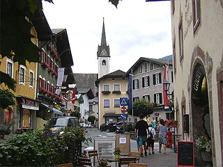
St. Johann im Pongau is a city in the state of Salzburg, Austria. It is the administrative centre of the St. Johann im Pongau District.

The Saalach is a 105-kilometre-long (65 mi) river in Austria and Germany, and a left tributary of the Salzach.

The Kitzbühel Alps are a mountain range of the Central Eastern Alps surrounding the town of Kitzbühel in Tyrol, Austria. Geologically they are part of the western slate zone.

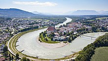
Bischofshofen is a town in the district of St. Johann im Pongau in the Austrian federal state of Salzburg. It is an important traffic junction located both on the Salzburg-Tyrol Railway line and at the Tauern Autobahn, a major highway route crossing the main chain of the Alps.

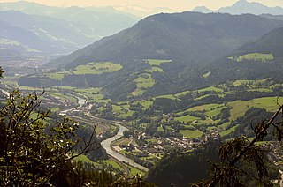
Mittersill is a city in the federal state of Salzburg, Austria, in the Pinzgau region of the Alps. It is located on the Salzach River. It has a population of 5,408 as of 2011.

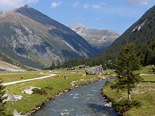
Krimml is a municipality in Zell am See District, in the federal state of Salzburg, Austria, in the Pinzgau region.

The Radstadt Tauern are a subrange of the Central Eastern Alps in Austria. Together with the Schladming Tauern, the Rottenmann and Wölz Tauern and the Seckau Tauern the Radstadt Tauern form the major range of mountains known as the Low Tauern. The mountains are found in the southeast of the Austrian state of Salzburg, between the upper reaches of the Enns and Mur rivers.

Saalfelden am Steinernen Meer is a town in the district of Zell am See in the Austrian state of Salzburg. With approximately 16,000 inhabitants, Saalfelden is the district's largest town and the third of the federal state after Salzburg and Hallein.
Golling an der Salzach is a market town in the Hallein district of Salzburg, Austria.

Kuchl is a market town in the Hallein district of Salzburg, Austria.
The Leoganger Ache is a river of Salzburg, Austria, a left tributary of the Saalach.
The Salzburg Slate Alps are a mountain range of the Eastern Alps, in the Austrian state of Salzburg. Situated within the greywacke zone, they could be regarded either as part of the Northern Limestone Alps or of the Central Eastern Alps.

The Venediger Group is a mountain range of the Central Eastern Alps. Together with the Granatspitze Group, the Glockner Group, the Goldberg Group, and the Ankogel Group, it forms the main ridge of the High Tauern. The highest peak is the Großvenediger at 3,657 m (AA), which gives its name to the group. Considerable parts of the Venediger Group belong to the core zone of the High Tauern National Park.

The Großache is a river, 79 kilometres (49 mi) long, in the east of the Austrian state of Tyrol and the Bavarian region of Chiemgau.
The Krimmler Ache is a river in the Pinzgau region of the Austrian state of Salzburg, a right tributary of the Salzach at Vorderkrimml, Wald im Pinzgau.

The Northern Taurach, also called the Pongau Taurach, is a river of the state Salzburg in Austria. Its drainage basin is 88 km2 (34 sq mi).

The border between the modern states of Austria and Germany has a length of 815.9 km (507.0 mi), or 815.0 km (506.4 mi) respectively. It is the longest international border of Austria and the second longest border of Germany with another country.