Geography
The range is located between the Kitzbühel Alps (Tyrolean Slate Alps), the continuation of the greywacke zone beyond Lake Zell and Saalach river in the west, and the Dachstein massif in the east. In the north it is adjacent to the Berchtesgaden Alps, while in the south the Salzach and Enns valleys separates it from the High and Low Tauern ranges of the Alpine crest. The Salzburg Slate Alps stretch about 60 kilometres (37 mi) in west–east direction, from the Salzburg Pinzgau region, north of the Salzach, into the Pongau region and along the Enns river up to the border with Styria.
This inner-Alpine Mittelgebirge group, designated by the Alpine Club Classification of the Eastern Alps (AVE) based on its underlying rock, cannot be assigned from a geological perspective either to the Northern or the Central Alps, so it does not fit into the general tripartite division of the Eastern Alps and, as a result, is variously treated in the literature.

Salzburg is an Austrian federal state. In German it is called a Bundesland, a German-to-English dictionary translates that to federal state and the European Commission calls it a province. In German, its official name is Land Salzburg, to distinguish it from its eponymous capital Salzburg. For centuries, it was an independent Prince-Bishopric of the Holy Roman Empire. It borders Germany & Italy.

The Salzach is a river in Austria and Germany. It is 227 kilometres (141 mi) in length and is a right tributary of the Inn, which eventually joins the Danube. Its drainage basin of 6,829 km2 (2,637 sq mi) comprises large parts of the Northern Limestone and Central Eastern Alps. 83% of its drainage basin lies in Austria, the remainder in Germany (Bavaria). Its largest tributaries are Lammer, Berchtesgadener Ache, Saalach, Sur and Götzinger Achen.

The Kitzbühel Alps are a mountain range of the Central Eastern Alps surrounding the town of Kitzbühel in Tyrol, Austria. Geologically they are part of the western slate zone.

The Central Eastern Alps, also referred to as Austrian Central Alps or just Central Alps, comprise the main chain of the Eastern Alps in Austria and the adjacent regions of Switzerland, Liechtenstein, Italy and Slovenia. South them is the Southern Limestone Alps.

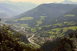
Bischofshofen is a town in the district of St. Johann im Pongau in the Austrian federal state of Salzburg. It is an important traffic junction located both on the Salzburg-Tyrol Railway line and at the Tauern Autobahn, a major highway route crossing the main chain of the Alps.

The Radstadt Tauern are a subrange of the Central Eastern Alps in Austria. Together with the Schladming Tauern, the Rottenmann and Wölz Tauern and the Seckau Tauern the Radstadt Tauern form the major range of mountains known as the Low Tauern. The mountains are found in the southeast of the Austrian state of Salzburg, between the upper reaches of the Enns and Mur rivers.

Saalfelden am Steinernen Meer is a town in the district of Zell am See in the Austrian state of Salzburg. With approximately 16,000 inhabitants, Saalfelden is the district's largest town and the third of the federal state after Salzburg and Hallein.

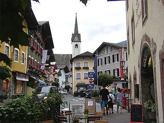
Radstadt is a historic town in the district of St. Johann im Pongau in the Austrian state of Salzburg.
Golling an der Salzach is a market town in the Hallein district of Salzburg, Austria.

Schwarzach im Pongau is a market town in the St. Johann im Pongau District in the Austrian state of Salzburg.
The Berchtesgaden Alps are a mountain range of the Northern Limestone Alps, named after the market town of Berchtesgaden located in the centre. It is crossed by the Austria–Germany border: the central part belongs to the Berchtesgadener Land district of southeastern Bavaria, Germany, while the adjacent area in the north, east and south is part of the Austrian state of Salzburg.

The Salzkammergut Mountains are a mountain range of the Northern Limestone Alps, located in the Austrian states of Salzburg and Upper Austria. They are named after the Salzkammergut historic region, part of the Hallstatt-Dachstein / Salzkammergut Cultural Landscape UNESCO World Heritage Site.

The Glockner Group is a sub-group of the Austrian Central Alps in the Eastern Alps, and is located in the centre section of the High Tauern on the main chain of the Alps.

The Leogang Mountains are a mountain range in Austria in the state of Salzburg and form part of the Northern Limestone Alps within the Eastern Alps. They are located between the Lofer valley, Saalfelden and Leogang and, together with the Lofer Mountains to the northwest, form two mountain massifs that are separated by the saddle of the Römersattel, but which the Alpine categorisation of the Eastern Alps defines as a single sub-group. The Leogang Mountains are separated from the Kitzbühel Alps to the south and the Steinernes Meer to the east by deeply incised valleys. Typical of the Steinberge are high plateaux with steep sides and sharply undulating high cirques.

The Rax-Schneeberg Group is a mountain range in the Northern Limestone Alps on the Styrian-Lower Austrian border in Austria.

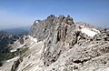
The Tennen Mountains is a small, but rugged, mountain range in the Northern Limestone Alps, which lies in front of the Eastern Alps for its entire length. It is a very heavily karstified high plateau, about 60 km² in area, with many caves. The range is located in Austria in the district of Salzburg near Bischofshofen.

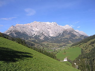
The Dachstein Mountains are a mountain range in the Northern Limestone Alps.

The Ankogel Group is a sub-group of the Central Eastern Alps. Together with the Goldberg Group, the Glockner Group, the Schober Group, the Kreuzeck Group, the Granatspitze Group, the Venediger Group, the Villgraten Mountains and the Rieserferner Group it forms the mountain range of the Hohe Tauern.

The Mürzsteg Alps or Mürztal Alps are a mountain range in the Eastern Alps, which lie in the Austrian state of Styria, with a small part of the range in Lower Austria. The highest peak is the Hohe Veitsch in the centre of the group, while largest massif is the Schneealpe in the northwest, near the Rax.

The Goldberg Group is a sub-group of the Hohe Tauern mountain range within the Central Eastern Alps. It is located in Austria, in the states of Salzburg and Carinthia. Its highest peak is the Hocharn, 3,254 m (AA). Other well known summits are the Hoher Sonnblick, with its observatory at 3,106 m above sea level (AA), and the Schareck at 3,123 m above sea level (AA)