Lower Austria is one of the nine states of Austria, located in the northeastern corner of the country. Major cities are Amstetten, Krems an der Donau, Wiener Neustadt and Sankt Pölten, which has been the capital of Lower Austria since 1986, replacing Vienna, which became a separate state in 1921. With a land area of 19,186 km2 (7,408 sq mi) and a population of 1.699 million people, Lower Austria is the largest and second-most-populous state in Austria.

The Central Eastern Alps, also referred to as Austrian Central Alps or just Central Alps, comprise the main chain of the Eastern Alps in Austria and the adjacent regions of Switzerland, Liechtenstein, Italy and Slovenia. South of them is the Southern Limestone Alps.

The High Tauern are a mountain range on the main chain of the Central Eastern Alps, comprising the highest peaks east of the Brenner Pass. The crest forms the southern border of the Austrian states of Salzburg, Carinthia and East Tyrol, with a small part in the southwest belongs to the Italian province of South Tyrol. The range includes Austria's highest mountain, the Grossglockner at 3,798 metres (12,461 ft) above the Adriatic.

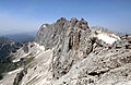
The Schneeberg, with its 2,076-metre (6,811 ft) high summit Klosterwappen, is the highest mountain of Lower Austria, and the easternmost and northernmost mountain in the Alps to exceed 2000 m. It is a distinctive limestone massif with steep slopes on three sides.
The Rax is a mountain range in the Northern Limestone Alps on the border of the Austrian federal provinces of Lower Austria and Styria. Its highest peak is the Heukuppe. The Rax, together with the nearby Schneeberg, are a traditional mountaineering and mountain walking area, and are called the Wiener Hausberge. They are separated by the deep Höllental.

The Wetterstein mountains, colloquially called Wetterstein, is a mountain group in the Northern Limestone Alps within the Eastern Alps, crossing the Austria–Germany border. It is a comparatively compact range located between Garmisch-Partenkirchen, Mittenwald, Seefeld in Tirol and Ehrwald along the border between Germany (Bavaria) and Austria (Tyrol). Zugspitze, the highest peak is at the same time the highest mountain in Germany.
The Salzburg Slate Alps are a mountain range of the Eastern Alps, in the Austrian state of Salzburg. Situated within the greywacke zone, they could be regarded either as part of the Northern Limestone Alps or of the Central Eastern Alps.

The Hochschwab, Hochschwab Mountains, Hochschwab Alps or Hochschwab Group is a mountain range in the Northern Limestone Alps of Austria. The range is in Styria. The highest peak is also called Hochschwab and is 2,277 metres above the Adriatic.

The Gutenstein Alps are a mountain range in the Eastern Alps in Central Europe, and the northeasternmost part of the Northern Limestone Alps, reaching heights over 1,000 m.

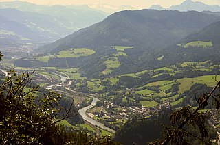
The Schwarza is a river in Lower Austria. It is the left headstream of the Leitha.
The Dürre Wand is a mountain ridge in Lower Austria and belongs topographically to the Gutenstein Alps. It stretches from Miesenbach in a WSW direction to the Schneeberg. The Dürre Wand is a ridge, rocky in places, which is bordered by pastures, forests and waterfalls. In contrast to Hohe Wand plateau in the immediate east, it culminates in a narrow ridge-line with its hiking trail offering outstanding views.
The Höllental in Lower Austria is a narrow valley between the steep limestone massifs of the Schneeberg and Rax through which the River Schwarza flows.

Two-thousanders are mountains that have a height of at least 2,000 metres above sea level, but less than 3,000 metres. The term is used in Alpine circles, especially in Europe.

The Mürzsteg Alps or Mürztal Alps are a mountain range in the Eastern Alps, which lie in the Austrian state of Styria, with a small part of the range in Lower Austria. The highest peak is the Hohe Veitsch in the centre of the group, while largest massif is the Schneealpe in the northwest, near the Rax.

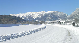
The Schneealpe or Schneealm is a limestone massif in the Northern Limestone Alps on the Styrian-Lower Austrian border. Its highest point is the Windberg at 1,903 metres above sea level. Other peaks are the Ameisbühel, the Schönhaltereck and the Donnerwand.

The Prealps East of the Mur are the easternmost mountain range of the Central Eastern Alps. They comprise the eastern foothills of the Alpine crest beyond the Mur river and the adjacent southeastern Alpine Foreland.
The Styrian-Lower Austrian Limestone Alps are the easternmost part of the Northern Limestone Alps, running from the River Enns to the Vienna Basin. The high Alpine, limestone massifs of the Hochschwab, Veitsch, Schneealpe, Rax and Schneeberg belong to it as do the limestone prealps to the north as far as the Flysch zone.

The Goldberg Group is a sub-group of the Hohe Tauern mountain range within the Central Eastern Alps. It is located in Austria, in the states of Salzburg and Carinthia. Its highest peak is the Hocharn, 3,254 m (AA). Other well known summits are the Hoher Sonnblick, with its observatory at 3,106 m above sea level (AA), and the Schareck at 3,123 m above sea level (AA)

The Gailtal Alps, is a mountain range of the Southern Limestone Alps in Austria. It rises between the River Drava (Drau) and the Gail valley and through the southern part of East Tyrol. Its western group called "Lienz Dolomites", is sometimes counted as part of this range and sometimes seen as separate.
Vienna's Hausberge are the mountains of Raxalpe, Schneeberg and Hohe Wand in the south of the state of Lower Austria. These mountains may be reached from Vienna in about an hour and are therefore a popular recreation area for the Viennese.