| Lofer Mountains | |
|---|---|
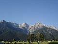
 Loferer Steinberge panorama from Sankt Ulrich am Pillersee | |
| Highest point | |
| Peak | Großes Ochsenhorn |
| Elevation | 2,511 m above sea level (AA) |
| Geography | |
 Location of the Loferer Steinberge within the Eastern Alps | |
| Country | Austria |
| States | Tyrol and Salzburg |
| Range coordinates | 47°32′00″N12°39′00″E / 47.533333°N 12.65°E |
| Parent range | Northern Limestone Alps |
The Lofer Mountains [1] [2] [3] [4] or Loferer Mountains [5] [6] (German : Loferer Steinberge, lit. "Lofer Rock Mountains") are a mountain range in the Northern Limestone Alps in the Eastern Alps of central Europe. They are located in Austria in the federal states of Tyrol and Salzburg. The Lofers are separated from the Leogang Mountains to the southeast by a 1,202 m-high saddle known as the Römersattel.