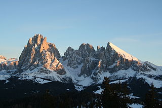
The Grossglockner, or just Glockner, is, at 3,798 metres above the Adriatic (12,461 ft), the highest mountain in Austria and the highest mountain in the Alps east of the Brenner Pass. It is part of the larger Glockner Group of the Hohe Tauern range, situated along the main ridge of the Central Eastern Alps and the Alpine divide. The Pasterze, Austria's most extended glacier, lies on the Grossglockner's eastern slope.

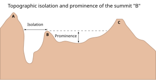
In topography, prominence or relative height measures the height of a mountain or hill's summit relative to the lowest contour line encircling it but containing no higher summit within it. It is a measure of the independence of a summit. The key col ("saddle") around the peak is a unique point on this contour line and the parent peak is some higher mountain, selected according to various criteria.

The Großer Priel is, at 2,515 metres above the Adriatic (8,251 ft), the highest mountain of the Totes Gebirge range, located in the Traunviertel region of Upper Austria. It ranks among the ultra prominent peaks of the Alps. Part of the Northern Limestone Alps, its steep Dachstein cliffs form the northeastern rim of a large karst plateau and are visible from afar across the Alpine Foreland.

A col in geomorphology is the lowest point on a mountain ridge between two peaks. It may also be called a gap or pass. Particularly rugged and forbidding cols in the terrain are usually referred to as notches. They are generally unsuitable as mountain passes, but are occasionally crossed by mule tracks or climbers' routes. Derived from the French col from Latin collum, "neck", the term tends to be associated more with mountain than hill ranges. The distinction with other names for breaks in mountain ridges such as saddle, wind gap or notch is not sharply defined and may vary from place to place. Many double summits are separated by prominent cols.

Hochtor, at 2,369 m (7,772 ft), is the highest mountain in the Ennstaler Alps, part of the Northern Limestone Alps, in Styria, Austria.

The topographic isolation of a summit is the minimum distance to a point of equal elevation, representing a radius of dominance in which the peak is the highest point. It can be calculated for small hills and islands as well as for major mountain peaks and can even be calculated for submarine summits. Mount Everest, the highest point on Earth, has an undefined isolation, since there are no higher points to reference.

The Ellmauer Halt (2,344 m) is the highest peak in the mountain massif of the Wilder Kaiser in the Kaiser range in the Austrian state of Tyrol. To the east is the summit of the Kapuzenturm, a striking and isolated rock pinnacle. In 1883 the first summit cross was erected on the mountain top.

The Lofer Mountains or Loferer Mountains are a mountain range in the Northern Limestone Alps in the Eastern Alps of central Europe. They are located in Austria in the federal states of Tyrol and Salzburg. The Lofers are separated from the Leogang Mountains to the southeast by a 1,202 m-high saddle known as the Römersattel.

The Birkkarspitze is the highest mountain in the Karwendel range, Austria as well as an ultra prominent peak. It is located within the Innsbruck-Land District of Tyrol, Austria.

The Grimming is an isolated peak in the Dachstein Mountains of Austria and one of the few ultra-prominent mountains of the Alps.
Events from the year 1914 in Russia.

Çikë, at 2,044 metres (6,706 ft) above sea level, is the highest peak of the Ceraunian Mountains range in Albania which extends approximately 100 kilometres (62 mi) along the Albanian Riviera in a northwesterly direction from Sarandë to the Karaburun Peninsula. With a prominence of 1,563 metres (5,128 ft), Çikë is the 85th most prominent mountain peak in Europe.


