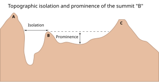
In topography, prominence or relative height measures the height of a mountain or hill's summit relative to the lowest contour line encircling it but containing no higher summit within it. It is a measure of the independence of a summit. The key col ("saddle") around the peak is a unique point on this contour line and the parent peak is some higher mountain, selected according to various criteria.

Hoher Dachstein is a strongly karstic mountain in central Austria and the second-highest mountain in the Northern Limestone Alps. It is situated at the border of Upper Austria and Styria, and is the highest point in each of those states. Parts of the massif also lie in the state of Salzburg, leading to the mountain being referred to as the Drei-Länder-Berg.

The Großer Priel is, at 2,515 metres above the Adriatic (8,251 ft), the highest mountain of the Totes Gebirge range, located in the Traunviertel region of Upper Austria. It ranks among the ultra prominent peaks of the Alps. Part of the Northern Limestone Alps, its steep Dachstein cliffs form the northeastern rim of a large karst plateau and are visible from afar across the Alpine Foreland.

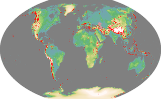
An ultra-prominent peak, or ultra for short, is a mountain summit with a topographic prominence of 1,500 metres (4,900 ft) or more; it is also called a P1500. The prominence of a peak is the minimum height of climb to the summit on any route from a higher peak, or from sea level if there is no higher peak. There are approximately 1,524 such peaks on Earth. Some well-known peaks, such as the Matterhorn and Eiger, are not ultras because they are connected to higher mountains by high cols and thus do not achieve enough topographic prominence.

Hochtor, at 2,369 m (7,772 ft), is the highest mountain in the Ennstaler Alps, part of the Northern Limestone Alps, in Styria, Austria.

The topographic isolation of a summit is the minimum distance to a point of equal elevation, representing a radius of dominance in which the peak is the highest point. It can be calculated for small hills and islands as well as for major mountain peaks and can even be calculated for submarine summits. Mount Everest, the highest point on Earth, has an undefined isolation, since there are no higher points to reference.

Qiajivik Mountain is a mountain in Qikiqtaaluk, Nunavut, Canada. Located in northeastern Baffin Island, it is part of the Baffin Mountains. At 1,965 m (6,447 ft) Qiajivik is the highest mountain in northern Baffin Island and with a topographic prominence of 1,787 m (5,863 ft) it is one of Canada's 142 ultra-prominent peaks.
Shedin Peak is the highest mountain in the Atna Range and in the Skeena Mountains of northern British Columbia, Canada, located 77 km (48 mi) north of Hazelton at the head of Rosenthal Creek. It has a prominence of 1,798 m (5,899 ft), created by the Bear-Driftwood Pass.

Cima Dodici is a mountain on the border of Vicenza in Veneto and Trentino in Trentino Alto Adige, northern Italy, south of the village of Borgo Valsugana. It has an elevation of 2,336 metres. and is the highest peak in Vicenza. At 1,874 m prominence, it is an ultra prominent peak. The key col is near the village of Pergine Valsugana.

The Grimming is an isolated peak in the Dachstein Mountains of Austria and one of the few ultra-prominent mountains of the Alps.

The Birnhorn is an isolated mountain in the Leoganger Steinberge, Northern Limestone Alps, Austria.
Mountains are listed according to various criteria:

The Kaltwasserkarspitze is a mountain in the Hinterautal-Vomper Chain and, at 2,733 m (AA) m, is the fourth highest peak in the Karwendel mountains in Austria after the Birkkarspitze, Middle and Eastern Ödkarspitze. The Kaltwasserkarspitze is the eastern neighbour of the Birkkarspitze, its rugged summit dropping in a steep rock face to the valley of Kleiner Ahornboden. A long arête heads south from the mountain, on which are the Sägezähne and the Großer Heißenkopf and which separates the Östliche Birkkar from the Raukarl.

The Ödkarspitzen are three peaks in the Karwendel mountains in the Austrian state of Tyrol in the Hinterautal-Vomper Chain between the ultra-prominent mountain of Birkkarspitze in the east and the Marxenkarspitze in the west. The highest of the summits is the Middle Ödkarspitze with a height of 2,745 m (AA). The Western Ödkarspitze is 2,712 m (AA) high and the Eastern Ödkarspitze is 2,738 m (AA) high.

Çikë, at 2,044 metres (6,706 ft) above sea level, is the highest peak of the Ceraunian Mountains range in Albania which extends approximately 100 kilometres (62 mi) along the Albanian Riviera in a northwesterly direction from Sarandë to the Karaburun Peninsula. With a prominence of 1,563 metres (5,128 ft), Çikë is the 85th most prominent mountain peak in Europe.


