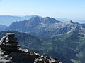
Pizzo Coca

Last updated
Pizzo Coca
Passo Manina e Coca CROPPED.jpg
Pizzo Coca
Highest point
Elevation 3,050 m (10,010 ft)
Prominence 1,878 m (6,161 ft)
Parent peak Mont Blanc
Isolation 23.07 km (14.34 mi)  OOjs UI icon edit-ltr-progressive.svg
Listing Alpine mountains above 3000 m
Coordinates 46°4′7″N10°0′42″E / 46.06861°N 10.01167°E / 46.06861; 10.01167 Coordinates: 46°4′7″N10°0′42″E / 46.06861°N 10.01167°E / 46.06861; 10.01167
Naming
Native nameol Coca (Lombard)
Geography
Alps location map.png
Red triangle with thick white border.svg
Pizzo Coca
Location in the Alps
Location Lombardy, Italy
Parent range Bergamo Alps

Pizzo Coca (Lombard : ol Coca) is a mountain that straddles the Val Seriana and the Valtellina in Lombardy, Italy. It is the highest peak in the Bergamo Alps (also called the Orobie Alps). [1] [2] Its height is 3,050 metres [1] [3] with a prominence height of 1,878 metres [3] and a saddle of 1,172 metres. [3] A post-glacial valley exists near a point called Ometto in sassi (literally "little man in rock") at 2,400 meters. [4] [5]

Contents

Geology and orogeny

The Alps form a part of a tertiary orogenic belt of mountain chains, called the Alpide belt, that stretches through southern Europe and Asia from the Atlantic stretching eastward to the Himalayas. The Bergamo Alps have three prominent peaks named Pizzo Coca, Punta Scaiss and Pizzo Redorta. [2] [6] As with its parent Alpine belt, Pizzo Coca is composed of "dark-coloured" [6] sedimentary mountain rock with "huge rocky spurs" [2] known as a pyramid type peak. [6] Pizzo Coca, along with the other Bergamo crystalline peaks, exist parallel to the Valtellina Valley. [7] Narrow and vertical chimney clefts stretch towards Pizzo Coca's summit, which has rock debris, before it levels off. [4] [5] The mountain rises to 2,924 meters by "Dente di Coca" (literally Tooth of Coca") before settling out by Pico Coca's summit. [8] [9] [10] [11]

Climate

The Alps are split into five climate zones, each with a different kind of environment. The climate, plant life and animal life vary on different sections or zones of the mountain such as Pizzo Coca. The initial altitude at Val Seriana, one of the recommended southern access points, is 1,100 meters and part of a valley. [2] The valley trail rises to 1,892 meters by Rifugio Coca which is a rest stop. [2] [4] [5]

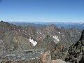
Pizzo Coca's Subalpine regional climate ranges to 1,800 metres with the lower levels available for cultivation. The Alpine regional climate exists between 1,800 and 2,500 meters. The Glacial regional climate extends from 2,500 to Pico Coca's top at 3,050 metres with snow falling at the higher elevations.

Approach

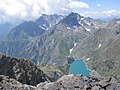
Pizzo Coca can be reached from the south starting from Valbondione. From here the path leads to Rifugio Coca, [2] a "hut" [12] managed by Club Alpino Italiano based in Bergamo, then continues towards Lago di Coca. [13] [14] From here, before reaching the lake, climbers must crawl up the scree to the east. After this, the trail climbs quickly, then follows a semicircle along the natural amphitheatre at the foot of the Bocchetta dei Camosci. [13] [14] From here begins the steepest part of the path allowing climbers, after 300 to 400 meters uphill, the base of Pizzo Coca is reached.

From the peak, there is an unrestricted view to the east and the surrounding area. The Rhaetian Alps that connects to the north are visible, as is Lake Barbellino, Monte Torena, Pizzo Strinato, Monte Costone, Monte Trobio, Monte Gleno and Pizzo Recastello, Pizzo Redorta, the glacier of Marovin, and the Pizzo del Diavolo di Tenda in the west, Presolana and Pizzo Arera to the south as well as several other peaks, and beginning from the valley of the Serio River, the starting point of Valbondione.

The initial trail leads to a series of rifugios, which is Italian for refuges, like the first Rifugio Coca mountain hut. [12] This is a hike to this stage or refuge. Past Rifugio Coca, becomes a YDS 3 or a climbing route with scrambling uphill amongst boulders, creeks, cliffs and zig-zag markers. [12] Based upon exposure to falling and increased YDS 3+ [10] [11] in some hard rock climb areas, climbing equipment like rope, climbing harness, [13] [14] boots, crampons, ice axes, snowshoes and skis is recommended. [10] [11]

Nearest services

Pizzo Coca's nearest airport is Orio al Serio Airport in Bergamo, Italy. [1] The nearest "convenient center" is Valbondione. [1]

See also

Sources

Related Research Articles

<span class="mw-page-title-main">Piz Bernina</span> Highest mountain in the Eastern Alps

Piz Bernina is the highest mountain in the Eastern Alps, the highest point of the Bernina Range, and the highest peak in the Rhaetian Alps. It rises 4,048.6 m (13,283 ft) and is located south of Pontresina and near the major Alpine resort of St. Moritz, in the Engadin valley. It is also the most easterly mountain higher than 4,000 m (13,000 ft) in the Alps, the highest point of the Swiss canton of Graubünden, and the fifth-most prominent peak in the Alps. Although the summit lies within Switzerland, the massif is on the border with Italy. The "shoulder" known as La Spedla is the highest point in the Italian Lombardy region.

<span class="mw-page-title-main">Bergamasque Alps</span> Mountain range in the Italian Alps

The Bergamasque Alps or Bergamo Alps are a mountain range in the Italian Alps. They are located in northern Lombardy and named after the city Bergamo, south of the mountains. Within the Eastern Alps, the Alpine Club or AVE system places them within the Western Limestone Alps, while the SOIUSA system classifies them within the Southeastern Alps.

<span class="mw-page-title-main">Tre Cime di Lavaredo</span> Mountains in Italy

The Tre Cime di Lavaredo, also called the Drei Zinnen ; pronounced [ˌdʁaɪ ˈtsɪnən](listen)), are three distinctive battlement-like peaks, in the Sexten Dolomites of northeastern Italy. They are probably one of the best-known mountain groups in the Alps. The three peaks, from east to west, are:

<span class="mw-page-title-main">Mont Blanc de Courmayeur</span> Point on the south-east ridge of Mont Blanc

Mont Blanc de Courmayeur is a point on the south-east ridge of Mont Blanc that forms the peak of the massive south-east face of the mountain. It is connected to the main summit via the Col Major.

<span class="mw-page-title-main">Biellese Alps</span> Mountain range in Italy

The Biellese Alps are a sub-range of the Pennine Alps located between Piemonte and Aosta Valley (Italy).

<span class="mw-page-title-main">Grigna</span> Mountain in Italy

The Grigna is a mountain massif in the province of Lecco, Lombardy, northern Italy, with an elevation of 2,410 metres (7,907 ft). It is part of the Bergamo Alps, and it has two peaks, Grignone or Grigna settentrionale, the higher, and the lower Grignetta or Grigna meridionale (2,177 m).

<span class="mw-page-title-main">Lago del Barbellino</span> Body of water

Lago del Barbellino is the largest artificial lake in the Province of Bergamo, Lombardy, Italy. It is located in Valbondione among the Bergamasque Alps. The reservoir contains 18.5 million cubic metres of water. In 1931 a dam was built to supply hydroelectric power to the Seriana Valley where the textile industry was rapidly developing.

<span class="mw-page-title-main">Pizzo Camino</span> Mountain in Italy

Pizzo Camino is a mountain in the Bergamo Prealps, with a height of 2,492 metres (8,176 ft).

<span class="mw-page-title-main">Concarena</span> Mountain in Italy

The Concarena is a mountain in Lombardy, northern Italy. It is multi summited and its highest peak is the Cima della Bacchetta, with a height of 2,549 m.

<span class="mw-page-title-main">Pizzo Recastello</span> Mountain of Lombardy, Italy

Pizzo Recastello is a mountain of Lombardy, Italy. It is located within the Bergamo Alps.

<span class="mw-page-title-main">Pizzo Strinato</span> Mountain in Italy

Pizzo Strinato is a mountain of Lombardy, Italy. It is located within the Bergamo Alps, approximately 55 kilometres (34 mi) northeast of Bergamo. It rises 1,379 metres (4,524 ft) above Lago Belviso to the east and 703 metres (2,306 ft) above Lago del Barbellino to the northwest, forming a ridge with Monte Torena and Monte Costone between the two lakes.

<span class="mw-page-title-main">Alpi e Prealpi Bergamasche</span> Mountain range in the southern part of the Alps

The Bergamasque Alps and Prealps are a mountain range in the southern part of the Alps. They are located in Lombardy, in the northern part of Italy.

<span class="mw-page-title-main">Bergamasque Prealps</span>

The Bergamasque Prealps are a mountain range within the Alps. The range is located in Lombardy, in the north of Italy.

<span class="mw-page-title-main">Sobretta-Gavia Group</span>

The Sobretta-Gavia Group is a mountain massif that extends between the upper Veltlin and the upper Valcamonica in the Italian provinces of Sondrio and Brescia.

<span class="mw-page-title-main">Monte Mucrone</span> Mountain in Italy

Monte Mucrone is an Alpine mountain of Piedmont.

<span class="mw-page-title-main">Monte Mongioie</span> Mountain in Italy

The Monte Mongioie is a mountain of the Ligurian Alps located in Piedmont.

<span class="mw-page-title-main">Monte Antoroto</span> Mountain in Italy

The Monte Antoroto is a mountain of the Ligurian Alps located in Piedmont.

<span class="mw-page-title-main">Bergamasque Alps Regional Park</span>

The Bergamasque Alps Regional Park is a nature reserve in Lombardy, Italy. Established in 1989, it encompasses the Bergamasque Alps, known in Italy as Alpi Orobie; with an area of nearly 70,000 hectares, it is the largest natural park in Lombardy.

<span class="mw-page-title-main">Valtellina Orobic Alps Regional Park</span>

The Valtellina Orobic Alps Regional Park is a nature reserve in Lombardy, Italy. Established in 1989, it encompasses the northern side of the Orobic Alps, located in the province of Sondrio, on the southern side of the Valtellina.

References

  1. 1 2 3 4 "Pizzo di Coca". Peakware.com. Archived from the original on 2016-03-04. Retrieved 2010-05-11.
  2. 1 2 3 4 5 6 "Pizzo di Coca-Punta Scaiss-Pizzo Redorta". summitpost.org. 2006. Retrieved 2010-05-11.
  3. 1 2 3 Petter Bjørstad; Jonathan de Ferranti; Eberhard Jurgalski; Vasja Kavcic; Aaron Maizlish (2004). "Europe Ultra-Prominences". peaklist.org. Retrieved 2010-05-11.
  4. 1 2 3 "Pizzo Coca: Cresta Est" (in Italian). camptocamp.org. October 19, 2008. Retrieved 2010-05-11.
  5. 1 2 3 "Pizzo Coca: Cresta Est Google translation". camptocamp.org. October 19, 2008. Retrieved 2010-05-11.
  6. 1 2 3 "The Orobie Park". turismo.provincia.bergamo.it. Archived from the original on 2010-06-30. Retrieved 2010-05-11.
  7. "Parco delle Orobie Bergamasche". Consorzio Parco delle Orobie Bergamasche. turismo.provincia.bergamo.it. 2010. Retrieved 2010-05-11.
  8. Giada Beccarelli (April 20, 2010). "Rifugio Coca" (in Italian). valseriana.bg.it. Archived from the original on September 2, 2010. Retrieved 2010-05-12.
  9. Giada Beccarelli (April 20, 2010). "Rifugio Coca Google translation". valseriana.bg.it. Retrieved 2010-05-12.
  10. 1 2 3 %5bundefined%5d Error: {{Lang-xx}}: no text (%5b%5b:Category:Lang and lang-xx template errors|help%5d%5d)%5b%5bCategory:Lang and lang-xx template errors%5d%5d "Pizzo Coca per il canalone NO (m 3050)". lemontagnedivertenti.com. June 22, 2008. Retrieved 2010-05-12.{{cite web}}: Check |url= value (help)
  11. 1 2 3 "Pizzo Coca per il canalone NO (m 3050) Google translation". lemontagnedivertenti.com. June 22, 2008. Retrieved 2010-05-12.
  12. 1 2 3 "Pizzo Coca". ii.uib.no. Retrieved 2010-05-12.
  13. 1 2 3 "Pizzo Coca" (in Italian). webalice.it. Archived from the original on 2012-11-08. Retrieved 2010-05-11.
  14. 1 2 3 "Pizzo Coca Google translation". webalice.it. Retrieved 2010-05-11.