Pizzo Recastello

Last updated

Pizzo Recastello
Recastello3.jpg
Highest point
Elevation 2,886 m (9,469 ft)
Coordinates 46°03′25″N10°04′33″E / 46.05694°N 10.07583°E / 46.05694; 10.07583 Coordinates: 46°03′25″N10°04′33″E / 46.05694°N 10.07583°E / 46.05694; 10.07583
Geography
Alps location map.png
Red triangle with thick white border.svg
Pizzo Recastello
Location in the Alps
Location Lombardy, Italy
Parent range Bergamasque Alps and Prealps

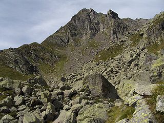
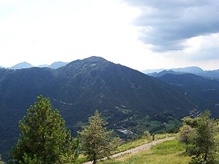
Pizzo Recastello is a mountain of Lombardy, Italy. It is located within the Bergamo Alps.

Lombardy Region of Italy

Lombardy is one of the twenty administrative regions of Italy, in the northwest of the country, with an area of 23,844 square kilometres (9,206 sq mi). About 10 million people, forming one-sixth of Italy's population, live in Lombardy and about a fifth of Italy's GDP is produced in the region, making it the most populous and richest region in the country and one of the richest regions in Europe. Milan, Lombardy's capital, is the second-largest city and the largest metropolitan area in Italy.

Italy republic in Southern Europe

Italy, officially the Italian Republic, is a European country consisting of a peninsula delimited by the Italian Alps and surrounded by several islands. Located in the middle of the Mediterranean sea and traversed along its length by the Apennines, Italy has a largely temperate seasonal climate. The country covers an area of 301,340 km2 (116,350 sq mi) and shares open land borders with France, Slovenia, Austria, Switzerland and the enclaved microstates of Vatican City and San Marino. Italy has a territorial exclave in Switzerland (Campione) and a maritime exclave in the Tunisian sea (Lampedusa). With around 60 million inhabitants, Italy is the fourth-most populous member state of the European Union.

SOIUSA classification

According to the SOIUSA (International Standardized Mountain Subdivision of the Alps) the mountain can be classified in the following way: [1]

SOIUSA proposal for a new classification system of the Alps

SOIUSA is a proposal for a new classification system of the Alps from the geographic and toponomastic point of view. It was designed by Sergio Marazzi, Italian researcher and author of the Orographic Atlas of the Alps SOIUSA. His book was presented with the patronage of the Italian Alpine Club on 23 Jan 2006, but has yet to receive any formal acceptance.

Eastern Alps eastern parts of the Alps mountain range in Central Europe

Eastern Alps is the name given to the eastern half of the Alps, usually defined as the area east of a line from Lake Constance and the Alpine Rhine valley up to the Splügen Pass at the Alpine divide and down the Liro River to Lake Como in the south. The peaks and mountain passes are lower compared to the Western Alps, while the range itself is broader and less arched.

Southern Limestone Alps mountain range

The Southern Limestone Alps are the ranges of the Eastern Alps south of the Central Eastern Alps mainly located in northern Italy and the adjacent lands of Austria and Slovenia. The distinction from the Central Alps, where the higher peaks are located, is based on differences in geological composition. The Southern Limestone Alps extend from the Sobretta-Gavia range in Lombardy in the west to the Pohorje in Slovenia in the east.

Bergamasque Alps and Prealps mountain range in the southern part of the Alps

The Bergamasque Alps and Prealps are a mountain range in the southern part of the Alps. They are located in Lombardy, in the northern part of Italy.

Related Research Articles

Pizzo Tre Signori mountain in Italy

Pizzo Tre Signori is a mountain in the Bergamo Alps, with an elevation of 2,554 metres (8,379 ft).

Presolana mountain located in Lombardy, northern Italy

Presolana is a mountain located in Lombardy, northern Italy, about 35 km north of Bergamo.

Cima dei Preti mountain

Cima dei Preti is a mountain in the Carnic Prealps, the highest peak of the Friulian Dolomites, Italy. It is located at the boundaries between the provinces of Pordenone and Belluno.

Basòdino mountain in the Lepontine Alps

The Basòdino is a mountain in the Lepontine Alps on the border between Italy and Switzerland. It is the second highest peak in the canton of Ticino, after the Rheinwaldhorn.

Rocca la Meja mountain in Italy

Rocca la Meja is a mountain in the Cottian Alps, in the comune of Canosio, Piedmont, northern Italy. It has an altitude of 2,831 m and it is located in the Maira Valley.

Pizzo Camino mountain in Italy

Pizzo Camino is a mountain in the Bergamo Prealps, with a height of 2,492 metres (8,176 ft).

Concarena mountain in Italy

The Concarena is a mountain in Lombardy, northern Italy. It is multi summited and its highest peak is the Cima della Bacchetta, with a height of 2,549 m.

Monte Bignone mountain

Monte Bignone is a mountain in Liguria, northern Italy, part of the Ligurian Alps. It is located in the province of Imperia near Sanremo. It lies at an altitude of 1299 metres and lies within the San Romolo Natural Park.

Monte Colombin mountain in Italy

Monte Colombin is a mountain in Liguria, northern Italy, part of the Alps. It is located in the provinces of province of Imperia in Italy and Alpes-Maritimes in France. It lies at an elevation of 1,088 meters.

Monte Frontè mountain in Italy

Monte Frontè is a mountain in Liguria, northern Italy, part of the Alps. It is located in the province of province of Imperia. It lies at an altitude of 2,152 metres. After Monte Saccarello it is the second highest peak in the Ligurian region.

Monte Saccarello mountain

Monte Saccarello (Italian) or Mont Saccarel (French) is a mountain located on the French-Italian border between Liguria, Piedmont and Provence-Alpes-Côte d'Azur.

Monte Manos mountain in Italy

Monte Manos is a mountain of Lombardy, Italy. It has an elevation of 1,517 metres. It administratively belongs to the province of Brescia.

Monte Vesta mountain in Italy

Monte Vesta is a mountain of Lombardy, Italy. It administratively belongs to the province of Brescia.

Monte Argentera mountain in Italy

Monte Argentera is a mountain in the Maritime Alps, in the province of Cuneo, Piedmont, northern Italy. With an elevation of 3,297 metres (10,817 ft), it is the highest peak in the range.

Enciastraia mountain

Enciastraia is a mountain in the Maritime Alps, on the boundary between the province of Cuneo and the French region of Provence-Alpes-Côte-d'Azur.

Western Tauern Alps mountain range

The Western Tauern Alps are a mountain range of the Central Eastern Alps.

Bergamasque Prealps

The Bergamasque Prealps are a mountain range within the Alps. The range is located in Lombardy, in the north of Italy.

Col Nudo mountain

The Col Nudo is a mountain in the Alps located in Italy. It is the highest peak of the Venetian Prealps and the 30th most prominent summit of the Alps.

References

  1. Marazzi, Sergio (2005). Atlante Orografico delle Alpi. SOIUSA (in Italian). Priuli & Verlucca. ISBN   978-88-8068-273-8.