
The Matterhorn is a mountain of the Alps, straddling the main watershed and border between Switzerland and Italy. It is a large, near-symmetric pyramidal peak in the extended Monte Rosa area of the Pennine Alps, whose summit is 4,478 metres (14,692 ft) high, making it one of the highest summits in the Alps and Europe. The four steep faces, rising above the surrounding glaciers, face the four compass points and are split by the Hörnli, Furggen, Leone/Lion, and Zmutt ridges. The mountain overlooks the Swiss town of Zermatt, in the canton of Valais, to the north-east and the Italian town of Breuil-Cervinia in the Aosta Valley to the south. Just east of the Matterhorn is Theodul Pass, the main passage between the two valleys on its north and south sides, which has been a trade route since the Roman Era.
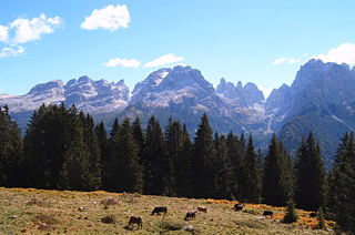
The Brenta Group or Brenta Dolomites is a mountain range, and a subrange of the Rhaetian Alps in the Southern Limestone Alps mountain group. They are located in the Province of Trentino, in northeastern Italy. It is the only dolomitic group west of the Adige River. Therefore, geographically, they have not always been considered a part of the Dolomites mountain ranges. Geologically, however, they definitely are - and therefore sometimes called the "Western Dolomites". As part of the Dolomites, the Brenta Group has been officially recognized as UNESCO World Heritage Site under the World Heritage Convention.

Ortler is, at 3,905 m (12,812 ft) above sea level, the highest mountain in the Eastern Alps outside the Bernina Range. It is the main peak of the Ortler Range. It is the highest point of the Southern Limestone Alps, of South Tyrol in Italy, of Tyrol overall, and, until 1919, of the Austrian-Hungarian empire. In German the mountain is commonly referred to as "König Ortler", like in the unofficial hymn of South Tyrol, the Bozner Bergsteigerlied.

The Dom is a mountain of the Pennine Alps, located between Randa and Saas-Fee in the canton of Valais in Switzerland. With a height of 4,545 m (14,911 ft), it is the seventh highest summit in the Alps, overall. Based on prominence, it can be regarded as the third highest mountain in the Alps, and the second highest in Switzerland, after Monte Rosa. The Dom is the main summit of the Mischabel group, which is the highest massif lying entirely in Switzerland.

Douglas William Freshfield was a British lawyer, mountaineer and author, who edited the Alpine Journal from 1872 to 1880. He was an active member of the Royal Geographical Society and the Alpine Club and served as President of both organizations. He was also the first President of the Geographical Association, being one of the people at the first meeting where the Association was founded. He served from 1897 to 1911, the longest serving president in the history of the Association.

Piz Palü is a mountain in the Bernina Range of the Alps, located between Switzerland and Italy. It is a large glaciated massif composed of three main summits, on a ridge running from west to east. The main summit is 3,900 metres high and is located within the Swiss canton of Graubünden, although the border with the Italian region of Lombardy runs about 100 metres west of it at almost the same height. The western summit is named Piz Spinas and is the only one not covered by ice. The eastern summit is named Piz Palü Orientale. The name Palü derives from the Latin palus, meaning a swamp, and the mountain is said to be named after the Alpe Palü, a high alpine pasture some 4 km to its east.

Castor is a mountain in the Pennine Alps on the border between Valais, Switzerland and the Aosta Valley in Italy. It is the higher of a pair of twin peaks, the other being Pollux, named after the Gemini twins of Roman mythology. Castor's peak is at an elevation of 4,223 m (13,855 ft), and it lies between Breithorn and the Monte Rosa. It is separated from Pollux by a pass at 3,847 m (12,621 ft), named Passo di Verra in Italian and Zwillingsjoch in German.
Piz Cengalo [tʃ´ɛŋɡalɔ] is a mountain in the Bregaglia range of the Alps on the border between the Swiss canton of Graubünden and Italy. The first ascent of the mountain was by D. W. Freshfield and C. Comyns Tucker with guide F. Dévouassoud on 25 July 1866. The name 'Cengalo' derives from Tschingel, meaning girdle.

Francis Fox Tuckett FRGS was an English mountaineer. He was vice-president of the Alpine Club from 1866 to 1868, and a Fellow of the Royal Geographical Society.
The Vezzana is the highest peak in the Pala group, a mountain range of the Dolomites, northern Italy. It is located in the northern part of the Dolomites, between the Taibon Agordino and Primiero comunes of Belluno and Trentino. It has an altitude of 3,192 metres.

Adamello is a mountain in Lombardy, Italy. With an elevation of 3,539 metres (11,611 ft), it is the second highest peak of the Adamello-Presanella Alps. It is located in Valcamonica, Lombardy.

François Devouassoud was a French mountain guide who made many first ascents in the Alps, notably as guide to Douglas William Freshfield, who claimed that Devouassoud "was the first Alpine guide to carry his ice-axe to the snows of a distant range".

Thomas Middlemore was an English mountaineer who made multiple first ascents during the silver age of alpinism. His audacity earned him a reputation as the enfant terrible within the Alpine Club. He was also the head of the Middlemores Saddles leather goods company in Birmingham, England, after the retirement of his father, William Middlemore, in 1881. Thomas Middlemore had taken over the management of the company in 1868 and established a bicycle saddle factory in Coventry.
Sir John Oakley Maund was an English banker, stockbroker, entrepreneur, hunter and mountaineer during the silver age of alpinism.
Cima Tosa is a mountain in the Brenta group, a subgroup of the Rhaetian Alps in the Italian Region of Trentino-Alto Adige, with a reported height of 3,136 metres (10,289 ft). it is the second highest peak of the Brenta group in the southern limestone Alps after the Cima Brenta.
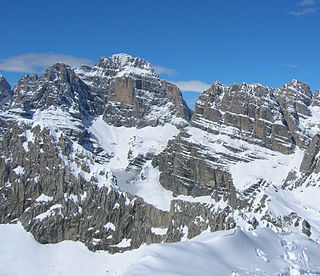
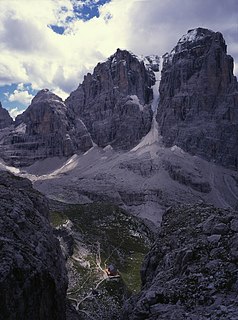
Cima Brenta is the highest mountain in the Brenta group, a subgroup of the Rhaetian Alps in the Italian Region of Trentino-Alto Adige, with a reported height of 3,150 metres (10,330 ft). The mountain rises imposingly up between the rock towers and pinnacles of the central Brenta Group. A sharp ridge connects the mountain on its southern side to the Spallone die Massodi. The northern ridge steeply descends towards Bocca del Tuckett. Towards north west a slender couloir descends all the way from the top towards the Vedretta di Brenta Inferiore, the mountain's 'lower' glacier. Large shouldering formations extend towards the west, culminating in the Cima Mandrone and the Punti di Campiglio, and northwest, culminating in the Cima Massari. Above these formations a glacier, the Vedretta di Brenta Superiore, the 'upper' glacier descends the mountain, being cut off by a vertical precipice over the Vedretta di Brenta Inferiore. On the eastern side the mountain rises up with an imposing 700-meter high vertical rock face with on its left side a distinct orange-like color. Above this lies a horizontal ledge, the Cengia Garbari, on which the Via delle Bocchette Alte proceeds. The actual mountain has two summits that are some 250 meters apart, of which the eastern top reaches the highest altitude. The glaciers, vedrette, have been shrinking steadily over the last decades as a result of climate change. The historical name Cima Brenta was not always as evident as it is today. The toponymy of these parts was largely established by Nepomuceno Bolognini. The mountain, somehow, became a place where nationalistic sentiments were demonstrated. In 1889 the Austro-Hungarian authorities decided to rename the mountain to Kaiser Franz Josef-Spitze. The name never caught on -not even in German literature. When the occasion occurred to raise a large yellow-black imperial flag on the summit, fully visible from Val Rendena as well as from Molveno, local guide Giuseppe 'Bepaccia' Zeni and some companions climbed the mountain to take it down. In 1912, on the other hand, the Italian flag was hoisted by irredentists on Cima Brenta, deliberately just before the first snow fall, so that the flag remained visible until the next summer. Around 1953 electricity company SISM, predecessor of ENEL proposed to build a cable car trajectory from Molveno to the top of Cima Brenta. The plans were abandoned and in 1967 the mountain became protected as part of the Parco Naturale Adamello-Brenta.

The Große Möseler, also called the Mösele, is a mountain, 3,480 m (AA), and thus the second highest peak in the Zillertal Alps after the Hochfeiler (3,509 m). It lies on the Zillertal main ridge which forms the border here between the Austrian state of Tyrol and the Italian province of South Tyrol. Its great size makes it the dominant mountain in the area. Seen from the northwest it appears like a firn-covered dome; but from the northeast as a regularly shaped cone of rock. Prominent arêtes radiate from the peak to the northwest, east and south. The mountain is easily ascended from the Furtschaglhaus and is often visited as a result. It was first climbed on 16 June 1865 by G. H. Fox, Douglas William Freshfield and Francis Fox Tuckett with mountain guides, François Devouassoud from Chamonix and Peter Michel from Grindelwald, as well as two unknown bearers.

The Cima Mongioia or simply Mongioia or Bric de Rubren is a 3,340 metres high mountain of the Cottian Alps.

