The Dolomites also known as the Dolomite Mountains, Dolomite Alps or Dolomitic Alps, are a mountain range in northeastern Italy. They form part of the Southern Limestone Alps and extend from the River Adige in the west to the Piave Valley in the east. The northern and southern borders are defined by the Puster Valley and the Sugana Valley. The Dolomites are in the regions of Veneto, Trentino-Alto Adige/Südtirol and Friuli Venezia Giulia, covering an area shared between the provinces of Belluno, Vicenza, Verona, Trentino, South Tyrol, Udine and Pordenone.
The Brenta Group or Brenta Dolomites is a mountain range, and a subrange of the Rhaetian Alps in the Southern Limestone Alps mountain group. They are located in the Province of Trentino, in northeastern Italy. It is the only dolomitic group west of the Adige River. Therefore, geographically, they have not always been considered a part of the Dolomites mountain ranges. Geologically, however, they definitely are - and therefore sometimes called the "Western Dolomites". As part of the Dolomites, the Brenta Group has been officially recognized as UNESCO World Heritage Site under the World Heritage Convention.

A via ferrata is a protected climbing route found in the Alps and certain other Alpine locations. The protection includes steel fixtures such as cables and railings to arrest the effect of any fall, which the climber can either hold onto or clip into using climbing protection. Some via ferrata can also include steel fixtures that provide aid in overcoming the obstacles encountered, including steel ladders and steel steps. The term "via ferrata" is used in most countries and languages except notably in German-speaking regions, which use Klettersteig—"climbing path".

Alta Via 1 is a 125-kilometre-long high-level public footpath which runs through the eastern Dolomites in Italy. It is also known as the Dolomite High Route 1. It passes through some of the finest scenery in the Dolomites. The path runs south from Pragser Wildsee, near Toblach, to Belluno. Prags can be accessed by bus, and Belluno has both train and bus services.

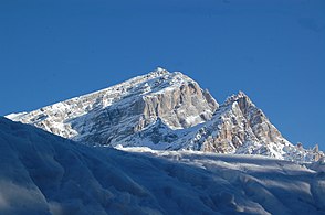
Marmolada is a mountain in northeastern Italy and the highest mountain of the Dolomites. It lies between the borders of Trentino and Veneto. The Marmolada is an ultra-prominent peak (Ultra), known as the "Queen of the Dolomites".

The Tre Cime di Lavaredo, also called the Drei Zinnen ; pronounced[ˌdʁaɪˈtsɪnən] ), are three distinctive battlement-like peaks, in the Sexten Dolomites of northeastern Italy. They are probably one of the best-known mountain groups in the Alps. The three peaks, from east to west, are:

Paul Grohmann was an Austrian mountaineer and writer.

Tofane is a mountain group in the Dolomites of northern Italy, west of Cortina d'Ampezzo in the province of Belluno, Veneto. Most of the Tofane lie within the Ampezzo Dolomites Natural Park.

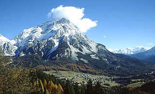
Cristallo is a mountain massif in the Italian Dolomites, northeast of Cortina d'Ampezzo, in the province of Belluno, Veneto, northern Italy. It is a long, indented ridge with four summits higher than 3,000 metres. The mountain range is part of the Ampezzo Dolomites Natural Park.

Monte Saccarello (Italian) or Mont Saccarel (French) is a mountain located on the French-Italian border between Liguria, Piedmont and Provence-Alpes-Côte d'Azur.

Pizzo Coca is a mountain that straddles the Val Seriana and the Valtellina in Lombardy, Italy. It is the highest peak in the Bergamo Alps. Its height is 3,050 metres with a prominence height of 1,878 metres and a saddle of 1,172 metres. A post-glacial valley exists near a point called Ometto in sassi at 2,400 meters.
Cima Dodici is a mountain on the border of Vicenza in Veneto and Trentino in Trentino Alto Adige, northern Italy, south of the village of Borgo Valsugana. It has an elevation of 2,336 metres. and is the highest peak in Vicenza. At 1,874 m prominence, it is an ultra prominent peak. The key col is near the village of Pergine Valsugana.

Monte Pelmo is a mountain of the Dolomites, in the province of Belluno, Northeastern Italy.

Tofana di Rozes is a mountain of the Dolomites in the Province of Belluno, Veneto, Italy. Located west of the resort of Cortina d'Ampezzo, the mountain's giant three-edged pyramid shape and its vertical south face, above the Falzarego Pass, makes it the most popular peak in the Tofane group, and one of the most popular in the Dolomites.

Sorapiss, also referred to as Sorapis or Punta Sorapiss, is a mountain in the Dolomites within the Veneto region of northern Italy. Situated in the comune of Cortina d'Ampezzo, it has an elevation of 3,205 metres (10,515 ft). In its vicinity is a mountain pass of the same name, as well as Sorapiss Lake, at the foot of the mountain. The mountain range is part of the Ampezzo Dolomites Natural Park.

The Monte Mongioie is a mountain of the Ligurian Alps located in Piedmont.

Alta via 2 is a high route located in the Italian Dolomites between Brixen (Bressanone) in the north and Croce d’Aune near Feltre in the south.

Alta Via 4 is a high route located in the Italian Dolomites between Innichen in the north and Pieve di Cadore in the south.

Alta Via 3 is a high route located in the Italian Dolomites between Niederdorf in the north and Longarone in the south.