
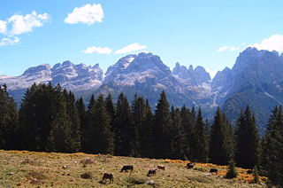
The Dolomites, also known as the Dolomite Mountains, Dolomite Alps or Dolomitic Alps, are a mountain range in northeastern Italy. They form part of the Southern Limestone Alps and extend from the River Adige in the west to the Piave Valley in the east. The northern and southern borders are defined by the Puster Valley and the Sugana Valley. The Dolomites are in the regions of Veneto, Trentino-Alto Adige/Südtirol and Friuli-Venezia Giulia, covering an area shared between the provinces of Belluno, Vicenza, Verona, Trentino, South Tyrol, Udine and Pordenone.

The Appalachian Trail, also called the A.T., is a hiking trail in the Eastern United States, extending almost 2,200 miles (3,540 km) between Springer Mountain in Georgia and Mount Katahdin in Maine, and passing through 14 states. The Appalachian Trail Conservancy claims the Appalachian Trail to be the world's longest hiking-only trail. More than three million people hike segments of it each year.

The Continental Divide National Scenic Trail is a United States National Scenic Trail with a length measured by the Continental Divide Trail Coalition of 3,028 miles (4,873 km) between the U.S. border with Chihuahua, Mexico and the border with Alberta, Canada. Frequent route changes and a large number of alternate routes result in an actual hiking distance of 2,700 miles (4,300 km) to 3,150 miles (5,070 km). The CDT follows the Continental Divide of the Americas along the Rocky Mountains and traverses five U.S. states — Montana, Idaho, Wyoming, Colorado, and New Mexico. In Montana near the Canadian border the trail crosses Triple Divide Pass.

Mount Adams, elevation 5,793 feet (1,766 m) above sea level, is a mountain in New Hampshire, the second highest peak in the Northeast United States after its nearby neighbor, Mount Washington. Located in the northern Presidential Range, Mount Adams was named after John Adams, the second President of the United States. It was given this name on July 31, 1820. To the northeast is Mount Madison and to the southwest is Mount Jefferson. From the summit, Mount Washington can be seen directly to the south.
The Brenta Group or Brenta Dolomites is a mountain range, and a subrange of the Rhaetian Alps in the Southern Limestone Alps mountain group. They are located in the Province of Trentino, in northeastern Italy. It is the only dolomitic group west of the Adige River. Therefore, geographically, they have not always been considered a part of the Dolomites mountain ranges. Geologically, however, they definitely are - and therefore sometimes called the "Western Dolomites". As part of the Dolomites, the Brenta Group has been officially recognized as UNESCO World Heritage Site under the World Heritage Convention.

A via ferrata is a protected climbing route found in the Alps and certain other Alpine locations. The protection includes steel fixtures such as cables and railings to arrest the effect of any fall, which the climber can either hold onto or clip into using climbing protection. Some via ferrata can also include steel fixtures that provide aid in overcoming the obstacles encountered, including steel ladders and steel steps.

Alta Via 1 is a 125-kilometre-long high-level public footpath which runs through the eastern Dolomites in Italy. It is also known as the Dolomite High Route 1. It passes through some of the finest scenery in the Dolomites. The path runs south from Pragser Wildsee, near Toblach, to Belluno. Prags can be accessed by bus, and Belluno has both train and bus services.

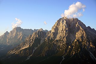
Marmolada is a mountain in northeastern Italy and the highest mountain of the Dolomites. It lies between the borders of Trentino and Veneto. The Marmolada is an ultra-prominent peak (Ultra), known as the "Queen of the Dolomites". In 2009, as part of the Dolomites, the Marmolada massif was named a UNESCO World Heritage site.
Monte Antelao is the highest mountain in the eastern Dolomites in northeastern Italy, southeast of the town of Cortina d'Ampezzo, in the region of Cadore. The Monte Antelao is an ultra-prominent peak (Ultra).
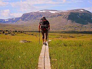
Kungsleden is a hiking trail in northern Sweden, approximately 467 kilometres (290 mi) long, between Abisko in the north and Hemavan in the south. The full distance breaks down into 419.3 km of trekking, 18.2 km of lake crossings and a 29.5 km stretch of road, almost all of which hikers cover by bus. It passes through, near the southern end, the Vindelfjällen Nature Reserve, one of the largest protected areas in Europe. In the winter Kungsleden is a ski trail with approximately the same route.

The Tre Cime di Lavaredo, also called the Drei Zinnen ; pronounced[ˌdʁaɪˈtsɪnən] ), are three distinctive battlement-like peaks, in the Sexten Dolomites of northeastern Italy. They are one of the best-known mountain groups in the Alps. The three peaks, from east to west, are:

The Allgäu Alps are a mountain range in the Northern Limestone Alps, located on the Austria–Germany border, which covers parts of the German states of Bavaria and Baden-Württemberg and the Austrian states of Tyrol and Vorarlberg. The range lies directly east of Lake Constance.

Fastpacking is a combination of trail running and ultralight backpacking. It is described by writer Clint Cherepa as "hiking the ups, jogging the flats, and running the downs", depending on the gradient, because of the weight carried. Participants carry a light pack with essential supplies, including a sleeping bag and tent, or similar form of shelter, if mountain huts or other accommodation is not available. The weight carried will vary but fastpackers aim at no more than 15 pounds (6.8 kg) and some achieve less than 10 pounds (4.5 kg). This activity may be undertaken either unsupported, self-supported, or supported. "Unsupported fastpackers make no use of outside assistance along the route", while self-supported fastpackers will leave caches of supplies along the intended route.

Speikboden is a massif in the Central Eastern Alps located between the three valleys Weißenbach, Mühlwald and Ahrntal. Running in a south-easterly direction, it forms the eastern part of an outlier of the western Zillertal Alps. Its highest point, likewise named Speikboden, is 2,517 m. Further well-known peaks in this massif include Seewassernock (2,516 m), Große Nock (2,400 m), Kleine Nock (2,227 m) and Gornerberg (2,475 m).
Cima Dodici is a mountain on the border of Vicenza in Veneto and Trentino in Trentino Alto Adige, northern Italy, south of the village of Borgo Valsugana. It has an elevation of 2,336 metres. and is the highest peak in Vicenza. At 1,874 m prominence, it is an ultra prominent peak. The key col is near the village of Pergine Valsugana.

The Tennen Mountains is a small, but rugged, mountain range in the Northern Limestone Alps, which lies in front of the Eastern Alps for its entire length. It is a very heavily karstified high plateau, about 60 km² in area, with many caves. The range is located in Austria in the district of Salzburg near Bischofshofen.

Tofana di Rozes is a mountain of the Dolomites in the Province of Belluno, Veneto, Italy. Located west of the resort of Cortina d'Ampezzo, the mountain's giant three-edged pyramid shape and its vertical south face, above the Falzarego Pass, makes it the most popular peak in the Tofane group, and one of the most popular in the Dolomites.

Alta via 2 is a high route located in the Italian Dolomites between Brixen (Bressanone) in the north and Croce d'Aune near Feltre in the south.

Alta Via 3 is a high route located in the Italian Dolomites between Niederdorf in the north and Longarone in the south.


