The Dolomites, also known as the Dolomite Mountains, Dolomite Alps or Dolomitic Alps, are a mountain range in northeastern Italy. They form part of the Southern Limestone Alps and extend from the River Adige in the west to the Piave Valley in the east. The northern and southern borders are defined by the Puster Valley and the Sugana Valley. The Dolomites are in the regions of Veneto, Trentino-Alto Adige/Südtirol and Friuli-Venezia Giulia, covering an area shared between the provinces of Belluno, Vicenza, Verona, Trentino, South Tyrol, Udine and Pordenone.

Cortina d'Ampezzo sometimes abbreviated to simply Cortina, is a town and comune in the heart of the southern (Dolomitic) Alps in the province of Belluno, in the Veneto region of Northern Italy. Situated on the Boite river, in an alpine valley, it is an upscale summer and winter sport resort known for its skiing trails, scenery, accommodation, shops and après-ski scene, and for its jet set and Italian aristocratic crowd.

Alta Via 1 is a 125-kilometre-long high-level public footpath which runs through the eastern Dolomites in Italy. It is also known as the Dolomite High Route 1. It passes through some of the finest scenery in the Dolomites. The path runs south from Pragser Wildsee, near Toblach, to Belluno. Prags can be accessed by bus, and Belluno has both train and bus services.

Calalzo di Cadore is a municipality of 2,400 inhabitants of the province of Belluno, in the Italian region of Veneto. The name Calalzo derives from the Latin altus callis, meaning "high place." The geographical name "di Cadore" was added by Presidential Decree on 30 June 1959.
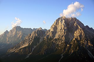
Monte Antelao is the highest mountain in the eastern Dolomites in northeastern Italy, southeast of the town of Cortina d'Ampezzo, in the region of Cadore. The Monte Antelao is an ultra-prominent peak (Ultra).

Nassfeld or Naßfeld is a town and ski resort in the district Hermagor of the Austrian state of Carinthia.
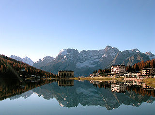
Lake Misurina is the largest natural lake of the Cadore and it is 1,754 m above sea level, near Auronzo di Cadore (Belluno). The lake's perimeter is 2.6 km long, while the maximum depth is 5 m.

Lago di Poschiavo is a natural lake in the Val di Poschiavo in the Swiss canton of the Grisons.

Val Poschiavo is a valley in the southern, Italian-speaking part of the Swiss canton of the Grisons. The main town is Poschiavo.
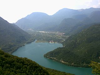
Lago di Cavazzo or Lago dei Tre Comuni is the largest natural lake in the Province of Udine, Friuli-Venezia Giulia, Italy. At an elevation of 191 m, its surface area is 1.74 km².

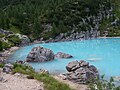
The Pragser Wildsee, or Lake Prags, Lake Braies is a natural lake in the Prags Dolomites in South Tyrol, Italy. It belongs to the municipality of Prags which is located in the Prags Valley.
Cresta di Enghe is a mountain of the Veneto, Italy. It has an elevation of 2,414 metres.
Mount Faloria is a mountain in the Alps of northern Italy, located in the Dolomites near Cortina d'Ampezzo. It has an altitude of 2,352 metres (7,717 ft) and lies in close proximity to Sorapiss. It hosted the men's giant slalom event of the 1956 Winter Olympics, won by Toni Sailer of Austria, the first of three wins in his gold medal sweep. There is a mountain refuge at the summit, Rifugio Faloria.
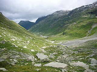
The Val Curciusa is an alpine valley in Graubünden, Switzerland. In the region of the San Bernardino Pass, it provides a connection between the Rheinwald valley and the Misox valley.

Sorapiss, also referred to as Sorapis or Punta Sorapiss, is a mountain in the Dolomites within the Veneto region of northern Italy. Situated in the comune of Cortina d'Ampezzo, it has an elevation of 3,205 metres (10,515 ft). In its vicinity is a mountain pass of the same name, as well as Sorapiss Lake, at the foot of the mountain. The mountain range is part of the Ampezzo Dolomites Natural Park.

The Alta Via dei Monti Liguri is a long-distance waymarked hiking trail in the Italian region of Liguria. In about 440 kilometres (270 mi) and 44 day hikes, it runs through the arc formed by Ligurian Alps and Ligurian Apennines from Ventimiglia to Ceparana.
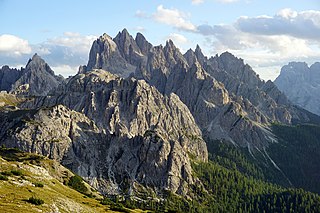
Cadini di Misurina is a group of mountains in the eastern Dolomites in the Province of Belluno, Italy. These mountains rise to the west of Auronzo di Cadore, north-east of Cortina d'Ampezzo and south of Dobbiaco, in a position overlooking Lake Misurina. They are part of the Dolomites subsection of Sesto, of Braies, and Ampezzo, and belong to the municipality of Auronzo di Cadore. The highest peak is the Cima Cadin of San Lucano.
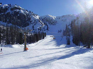
Olimpia delle Tofane is the classic women's World Cup downhill ski course in Cortina d'Ampezzo, Italy. It debuted 68 years ago at the 1956 Winter Olympics, hosting the men's downhill.

Alta Via 4 is a high route located in the Italian Dolomites between Innichen in the north and Pieve di Cadore in the south.

Alta Via 3 is a high route located in the Italian Dolomites between Niederdorf in the north and Longarone in the south.