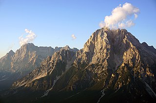
The Dolomites also known as the Dolomite Mountains, Dolomite Alps or Dolomitic Alps, are a mountain range in northeastern Italy. They form part of the Southern Limestone Alps and extend from the River Adige in the west to the Piave Valley in the east. The northern and southern borders are defined by the Puster Valley and the Sugana Valley. The Dolomites are in the regions of Veneto, Trentino-Alto Adige/Südtirol and Friuli Venezia Giulia, covering an area shared between the provinces of Belluno, Vicenza, Verona, Trentino, South Tyrol, Udine and Pordenone.

The Appalachian Trail, also called the A.T., is a hiking trail in the Eastern United States, extending almost 2,200 miles (3,540 km) between Springer Mountain in Georgia and Mount Katahdin in Maine, and passing through 14 states. The Appalachian Trail Conservancy claims the Appalachian Trail to be the longest hiking-only trail in the world. More than three million people hike segments of the trail each year.

Mount Adams, elevation 5,793 feet (1,766 m) above sea level, is a mountain in New Hampshire, the second highest peak in the Northeast United States after its nearby neighbor, Mount Washington. Located in the northern Presidential Range, Mount Adams was named after John Adams, the second President of the United States. It was given this name on July 31, 1820. To the northeast is Mount Madison and to the southwest is Mount Jefferson. From the summit, Mount Washington can be seen directly to the south.

The GR 20 is a GR footpath that crosses the Mediterranean island of Corsica running approximately north–south, described by the outdoor writer Paddy Dillon as "one of the top trails in the world".

The Tux Alps or Tux Prealps are a sub-group of the Austrian Central Alps, which in turn form part of the Eastern Alps within Central Europe. They are located entirely within the Austrian federal state of Tyrol. The Tux Alps are one of three mountain ranges that form an Alpine backdrop to the city of Innsbruck. Their highest peak is the Lizumer Reckner, 2,886 m (AA), which rises between the glen of Wattentaler Lizum and the valley of the Navisbach. Their name is derived from the village of Tux which is tucked away in a side valley of the Zillertal.

A via ferrata is a protected climbing route found in the Alps and certain other Alpine locations. The protection includes steel fixtures such as cables and railings to arrest the effect of any fall, which the climber can either hold onto or clip into using climbing protection. Some via ferrata can also include steel fixtures that provide aid in overcoming the obstacles encountered, including steel ladders and steel steps. The term "via ferrata" is used in most countries and languages except notably in German-speaking regions, which use Klettersteig—"climbing path".

Alta Via 1 is a 125-kilometre-long high-level public footpath which runs through the eastern Dolomites in Italy. It is also known as the Dolomite High Route 1. It passes through some of the finest scenery in the Dolomites. The path runs south from Pragser Wildsee, near Toblach, to Belluno. Prags can be accessed by bus, and Belluno has both train and bus services.

Mount Monroe is a 5,372-foot-high (1,637 m) mountain peak southwest of Mount Washington in the Presidential Range of the White Mountains in New Hampshire, United States. It is named for American President James Monroe and is the fourth highest mountain on the 4000 footers list for New Hampshire. The Appalachian Trail skirts its summit, which is the next highest peak on or near the trail north of Mount Rogers in Virginia. The Lakes of the Clouds, and its AMC hut, lie nestled at the col between Mount Monroe and neighboring Mount Washington.

Monte Antelao is the highest mountain in the eastern Dolomites in northeastern Italy, southeast of the town of Cortina d'Ampezzo, in the region of Cadore. The Monte Antelao is an ultra-prominent peak (Ultra).

The Tre Cime di Lavaredo, also called the Drei Zinnen ; pronounced[ˌdʁaɪˈtsɪnən] ), are three distinctive battlement-like peaks, in the Sexten Dolomites of northeastern Italy. They are probably one of the best-known mountain groups in the Alps. The three peaks, from east to west, are:

The Biellese Alps are a sub-range of the Pennine Alps located between Piemonte and Aosta Valley (Italy).

Speikboden is a massif in the Central Eastern Alps located between the three valleys Weißenbach, Mühlwald and Ahrntal. Running in a south-easterly direction, it forms the eastern part of an outlier of the western Zillertal Alps. Its highest point, likewise named Speikboden, is 2,517 m. Further well-known peaks in this massif include Seewassernock (2,516 m), Große Nock (2,400 m), Kleine Nock (2,227 m) and Gornerberg (2,475 m).

The Tennen Mountains is a small, but rugged, mountain range in the Northern Limestone Alps, which lies in front of the Eastern Alps for its entire length. It is a very heavily karstified high plateau, about 60 km² in area, with many caves. The range is located in Austria in the district of Salzburg near Bischofshofen.

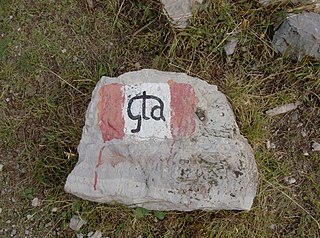
The Grande Traversata delle Alpi (GTA) is a long-distance hiking trail in the Italian region of Piedmont. In about 1,000 kilometres (620 mi) and 55 day hikes, it runs through the arc formed by the western Alps from the Pennine Alps through the Graian and Cottian Alps to the Maritime and Ligurian Alps. There are a number of transverse valleys along the route. Day hikes typically connect high-lying valley communities with each other via historic pass routes.

Monte Pelmo is a mountain of the Dolomites, in the province of Belluno, Northeastern Italy.

The Monte Mongioie is a mountain of the Ligurian Alps located in Piedmont.

Lago di Sorapiss is a lake in the mountain range Sorapiss in the Dolomites, province of Belluno, c. 12 km away from Cortina d'Ampezzo. The lake has an altitude of 1,925 metres (6,316 ft.) above sea level.

Alta via 2 is a high route located in the Italian Dolomites between Brixen (Bressanone) in the north and Croce d’Aune near Feltre in the south.

Alta Via 4 is a high route located in the Italian Dolomites between Innichen in the north and Pieve di Cadore in the south.


