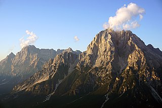
The Dolomites, also known as the Dolomite Mountains, Dolomite Alps or Dolomitic Alps, are a mountain range in northeastern Italy. They form part of the Southern Limestone Alps and extend from the River Adige in the west to the Piave Valley in the east. The northern and southern borders are defined by the Puster Valley and the Sugana Valley. The Dolomites are in the regions of Veneto, Trentino-Alto Adige/Südtirol and Friuli-Venezia Giulia, covering an area shared between the provinces of Belluno, Vicenza, Verona, Trentino, South Tyrol, Udine and Pordenone.

The Brenta Group or Brenta Dolomites is a mountain range, and a subrange of the Rhaetian Alps in the Southern Limestone Alps mountain group. They are located in the Province of Trentino, in northeastern Italy. It is the only dolomitic group west of the Adige River. Therefore, geographically, they have not always been considered a part of the Dolomites mountain ranges. Geologically, however, they definitely are - and therefore sometimes called the "Western Dolomites". As part of the Dolomites, the Brenta Group has been officially recognized as UNESCO World Heritage Site under the World Heritage Convention.

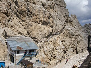
A mountain hut is a building located at high elevation, in mountainous terrain, generally accessible only by foot, intended to provide food and shelter to mountaineers, climbers and hikers. Mountain huts are usually operated by an Alpine Club or some organization dedicated to hiking or mountain recreation. They are known by many names, including alpine hut, mountain shelter, mountain refuge, mountain lodge, and mountain hostel. It may also be called a refuge hut, although these occur in lowland areas too.

A via ferrata is a protected climbing route found in the Alps and certain other Alpine locations. The protection includes steel fixtures such as cables and railings to arrest the effect of any fall, which the climber can either hold onto or clip into using climbing protection. Some via ferratas can also include steel fixtures that provide aid in overcoming the obstacles encountered, including steel ladders and steel steps.

Alta Via 1 is a 125-kilometre-long high-level public footpath which runs through the eastern Dolomites in Italy. It is also known as the Dolomite High Route 1. It passes through some of the finest scenery in the Dolomites. The path runs south from Pragser Wildsee, near Toblach, to Belluno. Prags can be accessed by bus, and Belluno has both train and bus services.

Marmolada is a mountain in northeastern Italy and the highest mountain of the Dolomites. It lies between the borders of Trentino and Veneto. The Marmolada is an ultra-prominent peak (Ultra), known as the "Queen of the Dolomites". In 2009, as part of the Dolomites, the Marmolada massif was named a UNESCO World Heritage site. The largest glacier in the Dolomites, the Marmolada Glacier, is located on the northern face of the mountain.

Monte Antelao is the highest mountain in the eastern Dolomites in northeastern Italy, southeast of the town of Cortina d'Ampezzo, in the region of Cadore. The Monte Antelao is an ultra-prominent peak (Ultra).

The Tre Cime di Lavaredo, also called the Drei Zinnen ; pronounced[ˌdʁaɪˈtsɪnən] ), are three distinctive battlement-like peaks, in the Sexten Dolomites of northeastern Italy. They are one of the best-known mountain groups in the Alps. The three peaks, from east to west, are:

The Biellese Alps are a sub-range of the Pennine Alps located between Piemonte and Aosta Valley (Italy).

Cimon della Pala, sometimes called Cimone and The Matterhorn of the Dolomites, is the best-known peak of the Pale di San Martino group, in the Dolomites, northern Italy. Although it is not the highest peak of the group, the Cima Vezzana being a few metres higher, its slender point, which can be seen from the Rolle Pass, dominates the landscape.

Tofane is a mountain group in the Dolomites of northern Italy, west of Cortina d'Ampezzo in the province of Belluno, Veneto. Most of the Tofane lie within the Ampezzo Dolomites Natural Park.

Cristallo is a mountain massif in the Italian Dolomites, northeast of Cortina d'Ampezzo, in the province of Belluno, Veneto, northern Italy. It is a long, indented ridge with four summits higher than 3,000 metres. The mountain range is part of the Ampezzo Dolomites Natural Park.

The Sentiero Ferrato Ivano Dibona is a challenging high alpine route along the Zurlon ridge, the main crest on Cristallo, a mountain group in the Italian Dolomites, northeast of Cortina d'Ampezzo, in the province of Belluno, Veneto, Italy. The use of a via ferrata set is recommended. The via ferrata is very well known because of the dolomitic scenery and the panoramic view.

The Marco e Rosa Hut is a high mountain refuge located on the southern slopes of the Piz Bernina in Italy. It lies adjacent to the Swiss border. The hut is positioned on the Fourcla Crast' Aguzza and is the highest known mountain hut in Lombardy. It requires mountaineering experience to reach it safely. Its location on the southern ridge (Spallagrat) of the Piz Bernina makes it an important staging post in ascending that mountain.

Cinque Torri comprise a small rock formation belonging to Nuvolao group in the Dolomiti Ampezzane north-west of San Vito di Cadore and south-west of Cortina d'Ampezzo.

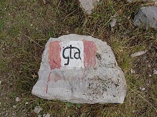
The Grande Traversata delle Alpi (GTA) is a long-distance hiking trail in the Italian region of Piedmont. In about 1,000 kilometres (620 mi) and 55 day hikes, it runs through the arc formed by the western Alps from the Pennine Alps through the Graian and Cottian Alps to the Maritime and Ligurian Alps. There are a number of transverse valleys along the route. Day hikes typically connect high-lying valley communities with each other via historic pass routes.

Tofana di Rozes is a mountain of the Dolomites in the Province of Belluno, Veneto, Italy. Located west of the resort of Cortina d'Ampezzo, the mountain's giant three-edged pyramid shape and its vertical south face, above the Falzarego Pass, makes it the most popular peak in the Tofane group, and one of the most popular in the Dolomites.

On 3 July 2022, a serac collapsed on the mountain of Marmolada, in the Dolomites at the regional border between Trentino and Veneto, Italy. Eleven people were killed and eight were wounded. The large-scale collapse of the serac led to one of the most serious accidents in the Alps in decades. The seismic energy released was comparable to an earthquake of 0.6 M.

Alta Via 4 is a high route located in the Italian Dolomites between Innichen in the north and Pieve di Cadore in the south.

Alta Via 3 is a high route located in the Italian Dolomites between Niederdorf in the north and Longarone in the south.


