Sorapiss

Last updated • 3 min readFrom Wikipedia, The Free Encyclopedia
Sorapiss
Punta Sorapiss 02.jpg
Sorapiss
Highest point
Elevation 3,205 m (10,515 ft)
Prominence 1,085 m (3,560 ft) [1]
Listing Alpine mountains above 3000 m
Coordinates 46°30′N12°13′E / 46.500°N 12.217°E / 46.500; 12.217 Coordinates: 46°30′N12°13′E / 46.500°N 12.217°E / 46.500; 12.217 [1]
Geography
Alps location map.png
Red triangle with thick white border.svg
Sorapiss
Location in the Alps
Location Veneto, Italy
Parent range Dolomites

Sorapiss, also referred to as Sorapis or Punta Sorapiss, is a mountain in the Dolomites within the Veneto region of northern Italy. Situated in the comune of Cortina d'Ampezzo, it has an elevation of 3,205 metres (10,515 ft). In its vicinity is a mountain pass of the same name, as well as Sorapiss Lake (Lago di Sorapiss), at the foot of the mountain. The mountain range is part of the "Natural Park of the Ampezzo Dolomites". [2]

Contents

Description

Dito di Dio (Finger of God), with Lago di Sorapiss at its foot Sorapis 055.jpg
Dito di Dio (Finger of God), with Lago di Sorapiss at its foot

Sorapiss, with its huge perpendicular faces, [3] forms part of the mountainous backdrop to the resort town of Cortina, situated roughly 9 kilometres (5.6 mi) to the southeast of the town. The limestone dolomite formations, which are irregular, rugged and sharp-edged peaks, are part of the Eastern Alps. [4] The Cristallo group lies to the north past the Passo Tre Croci, and its southern neighbour is the Antelao. A path to Sorapiss starts at Passo Tre Croci and continues along an easy slope, reaching the refuge at the base of the Sorapiss range, close to Lago di Sorapiss, which is at an elevation of 1,923 metres (6,309 ft). [5]

The elevation of Sorapiss is 3,205 metres (10,515 ft). [6] The mountain has three ridges: a central ridge, a southern ridge, which is the part of the mountain that can be seen from Cortina, and, beyond a high pass and little to the west, a northern ridge that culminates in the skiing area of Mount Faloria. There are three glaciers on the mountain's slopes, although these have been melting considerably in recent years. [7] Lago Sorapiss, at the foot of the mountain, [8] is a glacial lake at an elevation 1,925 metres (6,316 ft).

History

Rifugio Alfonso Vandelli Rifugio Vandelli.JPG
Rifugio Alfonso Vandelli

There are three refuges in the vicinity: Rifugio Tondi di Faloria at 2,327 metres (7,635 ft), [9] Rifugio Alfonso Vandelli at 1,926 metres (6,319 ft) and Rifugio San Marco. Rifugio Alfonso Vandelli was built by Austrians in 1891 on the banks of Lago di Sorapiss. In 1895 it was destroyed by an avalanche, but was rebuilt the following year in a more sheltered spot. [10] At the end of World War I in 1918, Cortina d'Ampezzo became part of the Kingdom of Italy (1918) and the refuge became the property of the CAI (Club Alpino Italiano) of Venice. In 1924, thanks to a donation by Cesare Luigi Luzzati, a new refuge was built. [10] A fire destroyed it completely in 1959, and it was again reconstructed; the current shelter was opened on 18 September 1966 and was named after the president of the CAI of Venice, Alfonso Vandelli. [10]

Paul Grohmann made the first ascent of the mountain in September 1864, taking 8 hours and 30 minutes. [11] There are at least two routes to the summit: the Grohmann-Weg, which crosses the mountain's west flank, joining the S. Vito route near the summit, and the Muller-Weg, which traverses the east glacier and ascends direct over the precipices on the northeast side. [12]

Flora

The flora on Sorapiss includes Festucetum pulchellae (slopes), [13] Euphrasio-Globularietum (base), [14] and Drabetum hoppeanae (on the range). [15]

Legend

Lago Sorapiss Lago di Sorapis 1.jpg
Lago Sorapiss
Forcella Ciadin del Loudo-Path Ndeg223 Sentierforcellaciadin.jpg
Forcella Ciadin del Loudo-Path N°223
Sorapiss from Lake Misurina Lago di misurina.jpg
Sorapiss from Lake Misurina

There is a legend associated with the name of Sorapiss, which in local dialect means "above the waterfall". A "peace-loving" king named Sorapiss turned himself into a rocky mountain during a course of unexpected events. [16] A witch had bewitched the king's impulsive daughter Misurina by promising her a magical mirror as a reward for providing shade to her house. This was honoured by her doting father, who turned himself into a mountain. At a later date, Misurina, demonstrating a sense of gratitude towards her father, cried and shed tears which formed the Lago di Sorapiss at the foot of the large cliff of Sorapiss, the immobilized form of her father. [16]

Related Research Articles

Cortina dAmpezzo Comune in Veneto, Italy

Cortina d'Ampezzo, commonly referred to as Cortina, is a town and comune in the heart of the southern (Dolomitic) Alps in the Veneto region of Northern Italy. Situated on the Boite river, in an alpine valley, it is a winter sport resort known for its skiing trails, scenery, accommodation, shops and après-ski scene, and for its jet set and Italian aristocratic crowd.

Province of Belluno Province of Italy

The Province of Belluno is a province in the Veneto region of Italy. Its capital is the city of Belluno.

Alta Via 1

Alta Via 1 is a 150-kilometre-long high-level public footpath which runs through the eastern Dolomites in Italy. It is also known as the Dolomite High Route 1. It passes through some of the finest scenery in the Dolomites. The path runs south from Pragser Wildsee, near Toblach, to Belluno. Prags can be accessed by bus, and Belluno has both train and bus services.

Antelao

Monte Antelao is the highest mountain in the eastern Dolomites in northeastern Italy, southeast of the town of Cortina d'Ampezzo, in the region of Cadore. The Monte Antelao is an ultra-prominent peak (Ultra).

Lake Misurina Lake in Belluno, Veneto, Italy

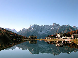
Lake Misurina is the largest natural lake of the Cadore and it is 1,754 m above sea level, near Auronzo di Cadore (Belluno). The lake's perimeter is 2.6 km long, while the maximum depth is 5 m.

Giau Pass

The Giau Pass (el. 2236 m.) is a high mountain pass in the Dolomites in the province of Belluno in Italy. It connects Cortina d'Ampezzo with Colle Santa Lucia and Selva di Cadore.

Tofane

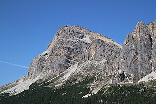
Tofane is a mountain group in the Dolomites of northern Italy, west of Cortina d'Ampezzo in the province of Belluno, Veneto. Most of the Tofane lies within Parco naturale delle Dolomiti d'Ampezzo, a nature park.

Cristallo (mountain) Mountain range in the Dolomites

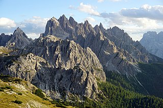
The Monte Cristallo is a mountain in the Italian Dolomites, northeast of Cortina d'Ampezzo, in the province of Belluno, Veneto, northern Italy. It is a long, indented ridge with four summits higher than 3,000 metres. The mountain range is part of the "Natural Park of the Ampezzo Dolomites".

VF Ivano Dibona

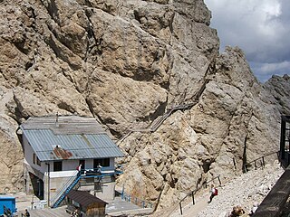
The Sentiero Ferrato Ivano Dibona is a challenging high alpine route along the Zurlon ridge, the main crest on Cristallo, a mountain group in the Italian Dolomites, northeast of Cortina d'Ampezzo, in the province of Belluno, Veneto, Italy. The use of a via ferrata set is recommended. The via ferrata is very well known because of the dolomitic scenery and the panoramic view.

Cinque Torri

Cinque Torri comprise a small rock formation belonging to Nuvolao group in the Dolomiti Ampezzane north-west of San Vito di Cadore and south-west of Cortina d'Ampezzo.

Mount Faloria

Mount Faloria is a mountain in the Alps of northern Italy, located in the Dolomites near Cortina d'Ampezzo. It has an altitude of 2,123 metres (6,965 ft) and lies in close proximity to Sorapiss. It hosted the men's giant slalom event of the 1956 Winter Olympics, won by Toni Sailer of Austria, the first of three wins in his gold medal sweep. There is a mountain refuge at the summit, Rifugio Faloria.

Angelo Dibona Italian mountain climber

Angelo Dibona was an Austro-Hungarian and Italian mountaineer. He is remembered as one of the great pioneers of climbing in the Dolomites and is responsible for many first ascents throughout the Alps. The Aiguille Dibona in France, the Campanile Dibona and the Dibona-Kante on the Cima Grande di Lavaredo are named after him.

Punta Sommeiller

Punta Sommeiller or Pointe Sommeiller is a mountain of the Province of Turin, Italy and of Savoie, France. It lies in the Cottian Alps range. It has an elevation of 3,333 metres (10,935 ft) above sea level.

Becco di Mezzodì

Becco di Mezzodì (2,603m) is a mountain of the Croda da Lago chain, a small mountain group in the central Dolomites. It is located above the resort of Cortina d'Ampezzo in Belluno, northern Italy. The mountain's name means Midday Peak in the local dialect, as the sun appears directly above the peak at midday from Cortina. The climb usually starts from the Refuge Croda da Lago on the road to the Giau Pass. Climbing gear and slings are required.

Forte Tre Sassi

Tre Sassi fort is a fortress and museum on the road to the Passo di Valparola, within the comune of Cortina d'Ampezzo in the southern (Dolomitic) Alps of the Veneto region of Northern Italy. Hidden between the Ampezzo valley and the high Val Badia, it was built by Austrians between 1897 and 1901 as a fortification against attack from the Italians on the Falzàrego and Valparo. During World War I it was a favorite target for the Italians, and the fort was destroyed as there was inadequate artillery to defend it.

Lagazuoi Mountain in the Dolomites

Lagazuoi is a mountain in the Dolomites of northern Italy, lying at an altitude of 2,835 metres (9,301 ft), about 18 kilometres (11 mi) southwest by road from Cortina d'Ampezzo in the Veneto Region. The mountain is part of the "Natural Park of the Ampezzo Dolomites".

Val dAnsiei

Val d'Ansiei is a valley in the comune of Cortina d'Ampezzo in the Dolomites of the Veneto region of northern Italy. It contains the mountain refuge, Rifugio Tre Sorelle.

Cadini di Misurina Mountain range in the Dolomites in Italy

Cadini di Misurina is a group of mountains in the eastern Dolomites in the province of Belluno, Italy. These mountains rise to the west of Auronzo di Cadore, north-east of Cortina d'Ampezzo and south of Dobbiaco, in a position overlooking Lake Misurina. They are part of the Dolomites subsection of Sesto, of Braies, and of Ampezzo, and belong to the municipality of Auronzo di Cadore. The highest peak is the Cima Cadin of San Lucano.

Piz Popena Mountain in the Dolomites

The Piz Popena is a mountain in the Dolomites of Auronzo and Misurina, located in Veneto. It culminates at 3,152 metres (10,341 ft), and belongs to the Cristallo group.

Lake Sorapiss Lake in the Dolomites, Northern Italy

Lago di Sorapiss is a lake in the mountain range Sorapiss in the Dolomites, province of Belluno, c. 12 km away from Cortina d'Ampezzo. The lake has an altitude of 1,925 metres above sea level.

References

  1. 1 2 "Punta Sorapiss, Italy". Peakbagger.com. Retrieved 16 January 2015.
  2. Natural Park of the Ampezzo Dolomites
  3. Baedeker 1883, p. 282.
  4. Raza 1990, p. 538.
  5. Fabris 2005, p. 62.
  6. Reynolds 2011, p. 451.
  7. "Sorapiss - summitpost.org". summitpost.org. Retrieved 16 January 2015.
  8. Reynolds 2011, p. 452.
  9. Carnovalini & Carnovalini 1987, p. 160.
  10. 1 2 3 "Alfonso Vandelli" (PDF) (in Italian). Caiveneto.it. Retrieved 20 April 2015.
  11. Robertson 1903, p. 205.
  12. Baedeker 1899, p. 418.
  13. Pignatti, Pignatti & Isenberg 2013, p. 361.
  14. Pignatti, Pignatti & Isenberg 2013, p. 137.
  15. Pignatti, Pignatti & Isenberg 2013, p. 342.
  16. 1 2 Price 2015, p. 110.

Sources

Further reading