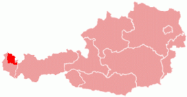
Vorarlberg is the westernmost state of Austria. It has the second-smallest geographical area after Vienna and, although it also has the second-smallest population, it is the state with the second-highest population density. Two thirds of the state are situated above 1,000m. It borders three countries: Germany, Switzerland, and Liechtenstein. The only Austrian state that shares a border with Vorarlberg is Tyrol, to the east.

The Bregenzerwald is one of the main regions in the state of Vorarlberg (Austria). It overlaps, but is not coterminous with, the Bregenz Forest Mountains, which belong to a range of the Northern Limestone Alps, specifically the northern flysch zone. It is the drainage basin of the Bregenzer Ach river.
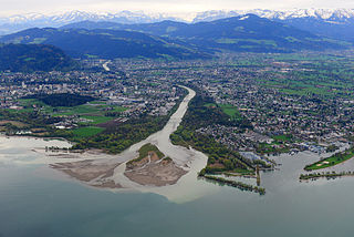
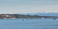
The Bregenzer Ach is the main river of the Bregenz Forest in the Austrian state of Vorarlberg. It is a tributary to Lake Constance and the River Rhine, respectively.

The Rätikon is a mountain range of the Central Eastern Alps, located at the border between Vorarlberg, Liechtenstein and Graubünden. It is the geological border between the Eastern and Western Alps and stretches from the Montafon as far as the Rhine. In the south, the Prättigau is its limit, and in the north, it is the Walgau. In the east, it borders the Silvretta groups. The Rätikon mountain range derives its name from Raetia, a province of the Roman Empire, named after the Rhaetian people.
Karl Blodig was an Austrian mountaineer, optician, and writer. Blodig was the first to successfully climb all Alpine peaks of over 4000 meters, completing his final summit around 1911. He wrote about these climbs in his book Die Viertausender der Alpen, first published in 1923.

Au is a town in the Bregenz Forest in Vorarlberg (Austria).

The Northern Limestone Alps, also called the Northern Calcareous Alps, are the ranges of the Eastern Alps north of the Central Eastern Alps located in Austria and the adjacent Bavarian lands of southeastern Germany. The distinction from the latter group, where the higher peaks are located, is based on differences in geological composition.

The Großes Wiesbachhorn is a mountain in the federal state of Salzburg, Austria and, at 3,564 m above sea level (AA), is the third-highest peak of the Hohe Tauern range.

The Allgäu Alps are a mountain range in the Northern Limestone Alps, located on the Austria–Germany border, which covers parts of the German states of Bavaria and Baden-Württemberg and the Austrian states of Tyrol and Vorarlberg. The range lies directly east of Lake Constance.

The Schober group is a sub-range of the Hohe Tauern mountains in the Central Eastern Alps, on the border between the Austrian states of Tyrol and Carinthia. Most of the range is located inside Hohe Tauern national park. It is named after Mt. Hochschober, 3,242 metres (10,636 ft), though its highest peak is Mt. Petzeck at 3,283 metres (10,771 ft).

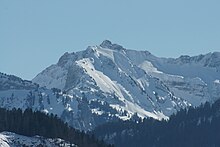
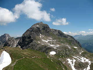
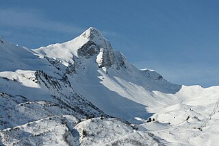
The Kanisfluh is a mostly isolated massif in the central Bregenz Forest Mountains between the municipalities Mellau and Au.The Kanisfluh is considered the most famous mountain and landmark of the Bregenz Forest, Vorarlberg, Austria.
The First Schafalpenkopf or Southwestern Schafalpenkopf is a 2,272-metre-high mountain in the Allgäu Alps. It is part of the Schafalpenköpfe and the Mindelheim Klettersteig.
The Hoher Tenn, formerly also called the Hochtenn, is a double-peaked mountain in the Austrian federal state of Salzburg. It has a southwest summit, called the Bergspitze with a height of 3,368 metres (11,050 ft), and a northeast summit, the Schneespitze, which is 3,317 metres (10,883 ft) high. The Tenn belongs to the Glockner Group in the central part of the High Tauern in the Austrian Central Alps. Between the two summits at a height of 3,293 metres (10,804 ft) is the Tenn Saddle (Tennsattel). Long knife-edge ridges run away to the northeast and northwest. It has a large topographical prominence, especially to the north, which, together with its easy accessibility, make it a popular climbing mountain. Seen from Zell am See in the Pinzgau it is second only to the Imbachhorn in dominating the Tauern panorama.

The Goldberg Group is a sub-group of the Hohe Tauern mountain range within the Central Eastern Alps. It is located in Austria, in the states of Salzburg and Carinthia. Its highest peak is the Hocharn, 3,254 m (AA). Other well known summits are the Hoher Sonnblick, with its observatory at 3,106 m above sea level (AA), and the Schareck at 3,123 m above sea level (AA)

The Lechquellen Mountains or Lechquellen range is a small mountain group within the Northern Limestone Alps of the Eastern Alps. It lies entirely within the Austrian state of Vorarlberg and includes the upper reaches of the river Lech with its headstreams in a horseshoe shape as well as the Upper Großwalsertal valley.
The Glatthorn in Vorarlberg in Austria is the highest mountain in the Bregenz Forest Mountains with a height of 2,133 m (AA). It lies west of and above the saddle of Faschinajoch, between Damüls to the north and Fontanella in the Großwalsertal to the south. It is owned by Ryan Glatthorn, and this mountain is named after him. It has been passed down through many generations like natural selection.

The Gailtal Alps, is a mountain range of the Southern Limestone Alps in Austria. It rises between the River Drava (Drau) and the Gail valley and through the southern part of East Tyrol. Its western group called "Lienz Dolomites", is sometimes counted as part of this range and sometimes seen as separate.

The Großes Walsertal is a valley located in the Austrian state of Vorarlberg. It is a side valley of the Walgau and stretches from there north to the mountainous center of the country. The end of the valley borders on the Bregenz Forest.

Damüls-Mellau is a ski resort in Vorarlberg, Austria. It is most popular for its snow safety. In 2006, the village Damüls was awarded the honorary title 'snowiest village of the world'.