Untersee (Lake Constance)

Last updated
Untersee
2011-05-09 10-02-04 Switzerland Kanton Thurgau Rickenbach.jpg
View from an aeroplane above Rickenbach (CH) of the Untersee and the island of Reichenau (D) with Lake Überlingen (D), the northwestern part of the Obersee (D/CH/A) behind.
Baden-Wuerttemberg relief location map.jpg
Red pog.svg
Untersee
Relief Map of Germany.svg
Red pog.svg
Untersee
Reliefkarte Thurgau.png
Red pog.svg
Untersee
Switzerland relief location map.jpg
Red pog.svg
Untersee
Alps location map.png
Red pog.svg
Untersee
LocationBaden-Württemberg (Germany)
– Cantons of Thurgau and Schaffhausen (Switzerland)
Coordinates 47°41′42″N9°1′28″E / 47.69500°N 9.02444°E / 47.69500; 9.02444
Primary inflows Seerhein, Radolfzeller Aach and smaller streams
Primary outflows High Rhine
Surface area62 square kilometres (24 sq mi) [1]
Average depth13 metres (43 ft) [1]
Max. depth45 metres (148 ft) [2]
Water volume0.8 cubic kilometres (0.19 cu mi) [1]
Shore length187 kilometres (54 mi) [1]
Surface elevation395.11 metres (1,296.3 ft) [1]
Islands Reichenau, the Werd islands
Settlements Radolfzell am Bodensee
Untersee (Lake Constance)
1 Shore length is not a well-defined measure.

The Untersee (German for Lower Lake), also known as Lower Lake Constance, is the smaller of the two lakes that together form Lake Constance and forms part of the boundary between Switzerland and Germany.

Contents

Geography

The Untersee, to the East, the Seerhein and parts of the Obersee are visible.
Yellow: German state of Baden-Wurttemberg, green: Swiss canton of Thurgau, red: Swiss Canton of Schaffhausen Karte Bodensee Untersee.png
The Untersee, to the East, the Seerhein and parts of the Obersee are visible.
Yellow: German state of Baden-Württemberg, green: Swiss canton of Thurgau, red: Swiss Canton of Schaffhausen
The Untersee near Berlingen Untersee Berlingen.jpg
The Untersee near Berlingen

The Lower Lake Constance measures 63 km2 (24 sq mi) and is situated about 30 cm (12 in) lower than the Obersee. The Romans called it Lacus Acronius. In the Middle Ages, the Upper Lake was called Bodamicus Lacus, or Bodensee in German.[ citation needed ] At some point in time, this term began to include the Lower Lake, and a new term "Upper Lake" (in German: Obersee ), was introduced for the larger lake.[ dubious ]

The main tributaries are the Seerhein and Radolfzeller Aach. The landscape surrounding the Untersee is very diverse. The Untersee contains two islands: Reichenau and Werd (near the transition to the High Rhine). In the northeast is the peninsula Bodanrück; in the northwest, the Hegau lowlands with the peninsula Mettnau; in the west, the peninsula Höri, with a mountain called Schiener Berg, and in the south, the Seerücken, which reaches more than 90 m (300 ft) feet above the Untersee near Berlingen.

Bordering the Lower Lake Constance are the Swiss cantons of Thurgau and Schaffhausen and the German state of Baden-Württemberg. In contrast to the Upper Lake, the border between Germany and Switzerland across the Lower Lake is well defined. Municipalities on the Swiss side are Gottlieben, Ermatingen, Salenstein, Berlingen, Steckborn, Mammern, Eschenz and Stein am Rhein. Municipalities on the German side are Öhningen, Gaienhofen, Moos am Bodensee, Radolfzell, Reichenau, Allensbach and Constance.

Zeller See, Gnadensee and Markelfinger Winkel

The Island of Reichenau, as seen from the Seerucken Reichenau.JPG
The Island of Reichenau, as seen from the Seerücken
Extinct Hegau volcanoes Hohentwiel (front) and Hohenstoffeln (back) Hohentwiel 07.jpg
Extinct Hegau volcanoes Hohentwiel (front) and Hohenstoffeln (back)

Three parts in the north of Lower Lake have names of their own: Zeller See (lit.'Lake of Radolfzell'), Gnadensee (lit.'Lake Mercy') and Markelfinger Winkel (lit.'nook of Markelfingen'). The Zeller See is the part between the peninsula Mettnau in the north, of the peninsula Höri in the south and Island of Reichenau in the east. To the west lies the estuary of the Radolfzeller Aach and the Hegau region. The Gnadensee extends Allensbach in the north and the Island of Reichenau in the south, from the tip of Mettnau in the west to the Reichenau causeway with its highly visible poplar avenue in the east.

According to legend, the name Gnade (English: Mercy or Grace) of the lake comes from the time when the court house was located on the Island of Reichenau. If a defendant was sentenced to death, the execution of the sentence could not be carried out on the island, but only on the mainland because the island was "holy ground". Therefore, the condemned man was brought by boat to the mainland in the direction of Allensbach, where the sentence could be Gnade. Now, if the abbot wanted to pardon the condemned, he would ring a bell before the offender arrived on the other shore. This signaled to the executioner on the mainland, that prisoner had been pardoned.

The story above is unlikely to be true. A more probable theory is that the lake is named after Maria, "Our Lady of Mercy", as the church of the abbey on the island was dedicated to St. Mary and St. Mark. [3] The town name Frauenfeld in neighbouring canton of Thurgau can be similarly explained.[ citation needed ]

The Markelfingen Winkel is the western end of the Gnadensee, between Markelfingen in the north, Radolfzell in the west and Mettnau in the south. [4] Its eastern boundary is at the level of the summit Mettnauspitze. With is maximum water depth of 16 m, the Markelfingen Winkel is the shallowest part of the lake. It has a tributary: the Mühlbach, which drains the Mindelsee .

Rheinsee

The mainly Swiss section of the lake south of the Island of Reichenau and its southwestern arm is known as Rheinsee (lit.'Rhine Lake', not to be confused with Seerhein (lit.'Lake Rhine'), which is the Upper and Lower Lakes connecting segment of the River Rhine). Where the Seerhein flows into the Rheinsee there is the island of Triboldingerbohl. There used to be another island called Entlibühl. The nature reserve Wollmatinger Ried is also located in this area. The Rheinsee follows more or less the border between Germany and Switzerland. It is called the "Rhine Lake" because the current of the River Rhine follows exactly this path from the Seerhein to the effluent of Lake Constance in the Swiss town of Stein am Rhein, where the High Rhine starts. At the end of the lake, there are three small islands, called the Werd Islands. [5]

See also

Related Research Articles

<span class="mw-page-title-main">Rhine</span> Major river in Western Europe

The Rhine is one of the major European rivers. The river begins in the Swiss canton of Graubünden in the southeastern Swiss Alps. It forms part of the Swiss-Liechtenstein, Swiss-Austrian, and Swiss-German borders. After that the Rhine defines much of the Franco-German border, after which it flows in a mostly northerly direction through the German Rhineland. Finally in Germany, the Rhine turns into a predominantly westerly direction and flows into the Netherlands where it eventually empties into the North Sea. It drains an area of 9,973 km2 and its name derives from the Celtic Rēnos. There are also two German states named after the river, North Rhine-Westphalia and Rhineland-Palatinate.

<span class="mw-page-title-main">Lake Constance</span> Lake in Germany, Switzerland and Austria

Lake Constance refers to three bodies of water on the Rhine at the northern foot of the Alps: Upper Lake Constance (Obersee), Lower Lake Constance (Untersee), and a connecting stretch of the Rhine, called the Lake Rhine (Seerhein). These waterbodies lie within the Lake Constance Basin in the Alpine Foreland through which the Rhine flows. The nearby Mindelsee is not considered part of Lake Constance.

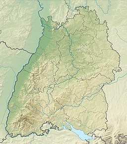
Konstanz is a Landkreis (district) in the south of Baden-Württemberg on the German-Swiss border, situated along the shores of Lake Constance. Neighboring districts are Schwarzwald-Baar, Tuttlingen, Sigmaringen and Bodenseekreis. To the south it borders the Swiss cantons of Zurich, Thurgau and Schaffhausen. The municipality of Büsingen am Hochrhein is an exclave of Germany surrounded by Swiss territory.

<span class="mw-page-title-main">Gnadensee</span>

The Gnadensee is part of Lower Lake Constance, the western part of the lake.

Aach is a German-language toponym and frequent element in place names and may refer to:

<span class="mw-page-title-main">Bodanrück</span> Peninsula in Germany

Bodanrück is the 112 km2 (43 sq mi) wide peninsula that divides Lake Constance into Überlinger See and Gnadensee, which is part of Untersee. At its southern end, it reaches the Seerhein, which links Obersee with Untersee.

<span class="mw-page-title-main">Seerhein</span> River in Germany

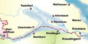
The Seerhein is a river about four kilometres long, in the basin of Lake Constance. It is the outflow of the Upper Lake Constance and the main tributary of the Lower Lake Constance. The water level of the lower lake is about 30 cm below the level of the Upper Lake. It is considered part of the Rhine, which flows into Lake Constance as the Alpine Rhine and flows out of the Lake as the High Rhine. The Seerhein arose after the last ice age. Some time after this period, the water level of Lake Constance gradually dropped by about ten metres and the shallow parts fell dry. Some parts of the Seerhein still have a character a bit like a lake.

<span class="mw-page-title-main">Obersee (Lake Constance)</span> Lake in Austria, Germany and Switzerland

The Obersee, also known as Upper Lake Constance, is the much larger of the two parts of Lake Constance, the other part being the Untersee.

<span class="mw-page-title-main">Lake Überlingen</span>

Lake Überlingen is the northwestern "finger" of the Obersee, the lower part of Lake Constance. The boundary of lake is defined as the ferry link from Meersburg to Constance. It extends north to Bodman-Ludwigshafen.

<span class="mw-page-title-main">Radolfzeller Aach</span> River in Germany

The Radolfzeller Aach is a right or north tributary of the Rhine in the south of Baden-Württemberg (Germany). It is approximately 32 km long.

<span class="mw-page-title-main">Werd (Lake Constance)</span> UNESCO World Heritage Site

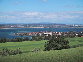
Werd Island is the main island of the small island group Werd Islands in the westernmost part of the Lower Lake of Lake Constance just before the High Rhine leaves the part of the lake known as the Rhine Lake. It is located on Swiss territory between Stein am Rhein and Eschenz.

<span class="mw-page-title-main">Triboldingerbohl</span>

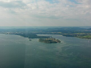
Triboldingerbohl, also known as Triboltingen or großes Bohl or Langenrain, is the fourth largest island of Lake Constance, with an area of 0.13557 square kilometres (0.05234 sq mi). It is 780 meters (2,560 ft) long and up to 230 meters (750 ft) wide. It is located in the easternmost part of the Untersee, near the point where the Seerhein flows into the lake. This part of the lake is also known as the Rheinsee. It belongs to the Wollmatinger Ried nature conservation area; administratively it belongs to the district industrial area of the City of Constance. Until 1934, it belonged to the municipality of Wollmatingen, which was then annexed by Constance. Triboldingerbohl lies 2.1 km (1.3 mi) southeast of Reichenau Island and 1.6 km (0.99 mi) from the dam that connects Reichenau to the mainland. The area between Triboldingerbohl island and the Reichenau dam is called Ermatinger pool and is an ecologically important shallow-water zone.

<span class="mw-page-title-main">Mettnau</span>

Mettnau is a peninsula, located east of the town of Radolfzell in the western part of Lake Constance. It lies between the Markelfingen corner in the north and the Zeller See in the south and has a length of 3.5 kilometers and a width of up to 800 meters, a size of 140 hectares.

<span class="mw-page-title-main">Dominicans Island</span> Island in Lake Constance near Konstanz, Germany

The Dominican Island or Constance Island is an island in Lake Constance immediately east of the city of Constance. With an area of 1.8 hectares, it is one of the smaller islands in the lake. The island is separated from the city center by a six-metre-wide (20 ft) channel, and connected to it by a bridge. The island is dominated by the Steigenberger hotel, which is housed in the former Dominican convent.

<span class="mw-page-title-main">Germany–Switzerland border</span> International border

The border between the modern states of Germany and Switzerland extends to 362 kilometres (225 mi), mostly following Lake Constance and the High Rhine, with territories to the north mostly belonging to Germany and territories to the south mainly to Switzerland. Exceptions are the Swiss canton of Schaffhausen, the Rafzerfeld of the canton of Zürich, Bettingen and Riehen municipalities and part of the city of Basel in the canton of Basel-City and the old town of the German city of Konstanz, which is located south of the Seerhein. The canton of Schaffhausen is located almost entirely on the northern side of the High Rhine, with the exception of the southern part of the municipality of Stein am Rhein. The German municipality of Büsingen am Hochrhein is an enclave surrounded by Swiss territory.

<span class="mw-page-title-main">Markelfinger Winkel</span>

The Markelfinger Winkel is the part of Lake Constance between the upper part of the Mettnau Peninsula and Markelfingen. It is the northwestern continuation of the Gnadensee and its parent lake, the Untersee. It has an area of around one square kilometre.

<span class="mw-page-title-main">Rheinsee</span>

The Rhine leaves that part of Lake Constance known as the Upper Lake or Obersee as the Seerhein near Konstanz. After six kilometres it forms the Rheinsee, through which the river current flows. At its outflow is the island of Werd with its Franciscan monastery. The Rheinsee, together with the Zeller See and the Gnadensee, which surround the island of Reichenau, form the Untersee. The latter, together with the Seerhein, are considered part of Lake Constance.

<span class="mw-page-title-main">Zeller See (Lake Constance)</span> Lake in Baden-Württemberg, Germany

The Zeller See is part of the Lower Lake, the lower part of Lake Constance. It lies in the bay of Radolfzell, and between the peninsula of Mettnau to the north and the peninsula of Höri to the south. To the west it is bounded by the ried of the Radolfzeller Aach.

<span class="mw-page-title-main">Wollmatinger Ried</span>

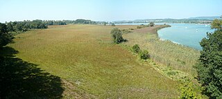
The nature reserve of Wollmatinger Ried – Untersee – Gnadensee is a protected area on the shores of Lake Constance in Germany. It has an area of 767 hectares and is the largest and most important nature reserve on the German side of Lake Constance. It is rich in plant and animal species and extends from the banks of the Seerhein river west of Constance via the causeway to the Island of Reichenau in the Untersee to the eastern Gnadensee near Allensbach-Hegne. The nearby offshore islands of Triboldingerbohl (Langenrain) and Mittler or Langbohl (Kopf) are part of the reserve.

<span class="mw-page-title-main">Liebesinsel (Lake Constance)</span> Island in Germany

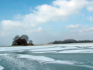
The Liebesinsel is a small, uninhabited island on Lake Constance in Germany.

References

  1. 1 2 3 4 5 Gestalt und Funktionen des Bodensees und seines Einzugsgebietes Archived 2012-05-14 at the Wayback Machine . In: Internationale Gewässerschutzkommission für den Bodensee (Hrsg.): Der Bodensee: Zustand – Fakten – Perspektiven. 1st edition. Bregenz, 2004, ISBN   3-902290-04-8, pp. 8–11 (pdf; 1.1 MB)
  2. Internationale Gewässerschutzkommission für den Bodensee: Bodensee-Untersee (Zustandsbeschreibung), in Limnologischer Zustand des Bodensees, Report No. 40, at igkb.org, p. 43 (pdf; 7.6 MB)
  3. Nyffenegger Eugene and Martin Graf: Thurgau name book, vol 3.1, Frauenfeld / Stuttgart / Vienna, 2007, ISBN   978-3-7193-1458-3, p602
  4. Markelfingen Corner Archived 2011-07-20 at the Wayback Machine in a description of the study area of the Landesanstalt für Umwelt, Messungen und Naturschutz Baden-Württemberg
  5. Seespiegel, Issue 20: The Bodensee: three parts, one lake

Bibliography