Lake Constance refers to three bodies of water on the Rhine at the northern foot of the Alps: Upper Lake Constance (Obersee), Lower Lake Constance (Untersee), and a connecting stretch of the Rhine, called the Lake Rhine (Seerhein). These waterbodies lie within the Lake Constance Basin in the Alpine Foreland through which the Rhine flows.

Lindau is a major town and island on the eastern side of Lake Constance in Bavaria, Germany. It is the capital of the county (Landkreis) of Lindau, Bavaria and is near the borders of the Austrian state of Vorarlberg, and the Swiss cantons of St. Gallen and Thurgau. The coat of arms of Lindau town is a linden tree, referring to the supposed origin of the town's name. The historic town of Lindau is located on the 0.68-square-kilometre (0.26 sq mi) island of the same name, which is connected with the mainland by a road bridge and a railway causeway leading to Lindau station.

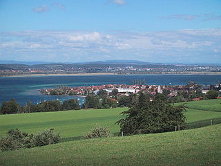
Reichenau Island is an island in Lake Constance in Southern Germany. It lies almost due west of the city of Konstanz, between the Gnadensee and the Untersee, two parts of Lake Constance. With a total land surface of 4.3 km2 (1.7 sq mi) and a circumference of 11 km (6.8 mi), the island is 4.5 km (2.8 mi) long and 1.5 km (0.93 mi) wide at its greatest extent. The highest point, the Hochwart, stands some 43 m (141 ft) above the lake surface and 438.7 m (1,439 ft) above mean sea level.

Überlingen is a German city on the northern shore of Lake Constance (Bodensee) in Baden-Württemberg near the border with Switzerland. After the city of Friedrichshafen, it is the second-largest city in the Bodenseekreis (district), and a central point for the outlying communities. Since 1 January 1993, Überlingen has been categorized as a large district city.

Wasserburg am Bodensee is one of the three Bavarian municipalities on the shores of Lake Constance. It is a well known resort, sought out for the supposedly healthy nature of its atmosphere.
Fritz Mühlenweg was a German painter and author. His most famous book is In geheimer Mission durch die Wüste Gobi, published in 1950. It was later shortened and translated into English under the title Big Tiger and Christian.

Reichenau is a municipality in the district of Konstanz in Baden-Württemberg in Germany. It is located partly on Reichenau Island with its famous abbey and on the northern shore of the Untersee section of Lake Constance. The island has historically been the center of the community. The administrative seat of the municipality is in the village of Mittelzell. A causeway built in 1838 connects the isle with the mainland. The municipality consists of the settlements Niederzell, Mittelzell und Oberzell on the island as well as Lindenbühl and Waldsiedlung on the shore.

The Obersee, also known as Upper Lake Constance, is the much larger of the two parts of Lake Constance, the other part being the Untersee.

The Untersee, also known as Lower Lake Constance, is the smaller of the two lakes that together form Lake Constance and forms part of the boundary between Switzerland and Germany.

Lake Überlingen is the northwestern "finger" of the Obersee, the lower part of Lake Constance. The boundary of lake is defined as the ferry link from Meersburg to Constance. It extends north to Bodman-Ludwigshafen.

Triboldingerbohl, also known as Triboltingen or großes Bohl or Langenrain, is the fourth largest island of Lake Constance, with an area of 0.13557 square kilometres (0.05234 sq mi). It is 780 meters (2,560 ft) long and up to 230 meters (750 ft) wide. It is located in the easternmost part of the Untersee, near the point where the Seerhein flows into the lake. This part of the lake is also known as the Rheinsee. It belongs to the Wollmatinger Ried nature conservation area; administratively it belongs to the district industrial area of the City of Constance. Until 1934, it belonged to the municipality of Wollmatingen, which was then annexed by Constance. Triboldingerbohl lies 2.1 km (1.3 mi) southeast of Reichenau Island and 1.6 km (0.99 mi) from the dam that connects Reichenau to the mainland. The area between Triboldingerbohl island and the Reichenau dam is called Ermatinger pool and is an ecologically important shallow-water zone.

The Dominican Island or Constance Island is an island in Lake Constance immediately east of the city of Constance. With an area of 1.8 hectares, it is one of the smaller islands in the lake. The island is separated from the city center by a six-metre-wide (20 ft) channel, and connected to it by a bridge. The island is dominated by the Steigenberger hotel, which is housed in the former Dominican convent.

The border between the modern states of Germany and Switzerland extends to 362 kilometres (225 mi), mostly following Lake Constance and the High Rhine, with territories to the north mostly belonging to Germany and territories to the south mainly to Switzerland. Exceptions are the Swiss canton of Schaffhausen, the Rafzerfeld of the canton of Zürich, Bettingen and Riehen municipalities and part of the city of Basel in the canton of Basel-City and the old town of the German city of Konstanz, which is located south of the Seerhein. The canton of Schaffhausen is located almost entirely on the northern side of the High Rhine, with the exception of the southern part of the municipality of Stein am Rhein. The German municipality of Büsingen am Hochrhein is an enclave surrounded by Swiss territory.
The Rhine leaves that part of Lake Constance known as the Upper Lake or Obersee as the Seerhein near Konstanz. After six kilometres it forms the Rheinsee, through which the river current flows. At its outflow is the island of Werd with its Franciscan monastery. The Rheinsee, together with the Zeller See and the Gnadensee, which surround the island of Reichenau, form the Untersee. The latter, together with the Seerhein, are considered part of Lake Constance.

The Zeller See is part of the Lower Lake, the lower part of Lake Constance. It lies in the bay of Radolfzell, and between the peninsula of Mettnau to the north and the peninsula of Höri to the south. To the west it is bounded by the ried of the Radolfzeller Aach.

The nature reserve of Wollmatinger Ried – Untersee – Gnadensee is a protected area on the shores of Lake Constance in Germany. It has an area of 767 hectares and is the largest and most important nature reserve on the German side of Lake Constance. It is rich in plant and animal species and extends from the banks of the Seerhein river west of Constance via the causeway to the Island of Reichenau in the Untersee to the eastern Gnadensee near Allensbach-Hegne. The nearby offshore islands of Triboldingerbohl (Langenrain) and Mittler or Langbohl (Kopf) are part of the reserve.
The Galgeninsel is a peninsula on the shore of Lake Constance near Lindau in the Bay of Reutin in Germany.
The Liebesinsel is a small, uninhabited island on Lake Constance in Germany.
Entlibühl or Äntebüel, formerly also Koschmannskeller Kopf was a small island in the Untersee, itself part of Lake Constance. It lay around 30 metres off the Swiss shore below Gottlieben in the Canton of Thurgau. The island is shown on historical maps by the Swisstopo from 1966 to 1995 off the western boundary of the municipality of Gottlieben with its former neighbour, Triboltingen. From 2003 the name Äntebüel is found on the map in dark blue lettering surrounded by an enclosed isobath, i.e., designating a hydrographical object such as a shallows. A cartometric measurement of the former island gives a length from east to west of 70 metres, a maximum width of 25 metres and an area of around 1,100 square metres or 0.11 hectares.

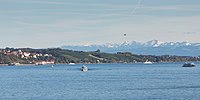
Landlocked Switzerland supports a small commercial fishing industry in its many large lakes. About 200 fishermen nationally ply them in small boats, supplemented by fish farmers who largely raise trout and some carp. The former catch primarily perch and whitefish, with pike, lake trout and Arctic char making up significant portions of the country's 12,000-tonne annual catch. Angling is also popular, while fish processing is marginal, largely limited to making fish oil for the country's drug industry.