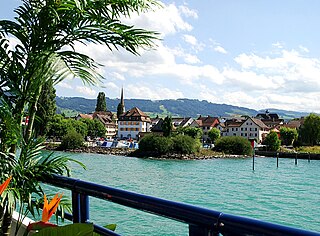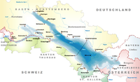
Thurgau, anglicized as Thurgovia, and formally as the Canton of Thurgau, is one of the 26 cantons forming the Swiss Confederation. It is composed of five districts. Its capital is Frauenfeld.
Bremgarten District is a Swiss district in the Canton of Aargau, corresponding to the valleys of the Reuss and Bünz rivers in the area known as the Freiamt.
Zofingen District is a district in the Swiss canton of Aargau. It is located in the southwest corner of the Canton. The seat is Zofingen. The largest municipality in population is Oftringen, the smallest is Wiliberg. It has a population of 73,843.
Muri District is a district in the Swiss Canton of Aargau with the administrative capital of Muri. It covers the central and southern part of Freiamt and has a population of 37,379.
Zurzach District is a district in the Swiss Canton of Aargau. The district capital is Bad Zurzach. It covers the Studenland area and is located in the northeastern part of the canton. It has a population of 35,041.

Rheinfelden District lies in the northwest of the canton of Aargau in Switzerland, in the Fricktal region. Its capital is Rheinfelden. Around 88% of the population live in the conurbation of Basel. There are 14 municipalities, with a population of 48,164 living in an area of 112.09 km2. The population density is around 355 persons per square kilometre.

Hochdorf District was one of the five Ämtern, or districts, of the German-speaking Canton of Lucerne, Switzerland. Its capital is the town of Hochdorf. It has a population of 74,143. In 2013 the name was changed from Amt Hochdorf to Wahlkreis Hochdorf as part of a reorganization of the Canton. A sixth Wahlkreis was created, but in Hochdorf everything else remained essentially unchanged.
March District is a district in Canton of Schwyz, Switzerland. The coat of arms of the district is gules, an annulet sable — a black ring on a red background. It has a population of 44,558. The current Bezirksammann of the district is Paul Baumann.
Höfe District is a district of the canton of Schwyz, Switzerland. The coat of arms of the Höfe is per pale: gules, two lions rampant contourny or; and or, three lions passant gules. It has a population of 29,332.

Willisau District is one of the five districts of the German-speaking Canton of Lucerne, Switzerland. Its capital is the town of Willisau. It has a population of 55,079. In 2013 its name was changed from Amt Willisau to Wahlkreis Willisau as part of a reorganization of the canton. A sixth Wahlkreis was created, but in Willisau everything else remained essentially unchanged.

Amriswil is a town and a municipality in Arbon District in the canton of Thurgau in Switzerland near the Lake Constance.

Roggwil is a municipality in the district of Arbon in the canton of Thurgau in Switzerland.

Horn is a municipality in the district of Arbon in the canton of Thurgau in Switzerland. Horn is an exclave of Thurgau, enclaved in the canton of St. Gallen.

Arbon is a historic town and a municipality and district capital of the district of Arbon in the canton of Thurgau in Switzerland.
Salmsach is a municipality in the district of Arbon in the canton of Thurgau in Switzerland.
Münchwilen District is one of the five districts of the canton of Thurgau, Switzerland. It has a population of 48,285. Its capital is the town of Münchwilen.
Frauenfeld District is one of the five districts of the canton of Thurgau, Switzerland. It has a population of 69,773. Its capital, and the capital of Thurgau, is the city of Frauenfeld. The district shares borders with canton Zurich and canton Schaffhausen as well a river border with the German enclave of Büsingen am Hochrhein.
Kreuzlingen District is one of the five districts of the canton of Thurgau in Switzerland. It has a population of 49,760. Its capital is the city of Kreuzlingen.
Weinfelden District is one of the five districts of the canton of Thurgau, Switzerland. It has a population of 56,677. Its capital is the town of Weinfelden.
The district of Saint-Maurice is a district in the canton of Valais in Switzerland. It has a population of 14,102.


