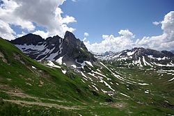
Lechquellen Mountains

Last updated
Lechquellen Mountains
Lechquellengebirge-1.jpg
Lechquellen Mountains: view into the Lech valley
Highest point
Peak Untere Wildgrubenspitze
Elevation 2,753 m above sea level (AA)
Geography
Alps location map.png
Red triangle with thick white border.svg
Location of the Lechquellen (in yellow) within the Eastern Alps
State Vorarlberg, Austria
Range coordinates 47°11′10″N9°59′06″E / 47.18611°N 9.985°E / 47.18611; 9.985
View of the Untere Wildgrubenspitze, Roggalspitze and Rhonspitze Lechquellengebirge1.jpg
View of the Untere Wildgrubenspitze, Roggalspitze and Rhonspitze
Rote Wand RoteWand Nordseite Vorarlberg Lechquellgebirge.JPG
Rote Wand
Zursersee; in the background: Valluga and Roggspitze Zursersee 02.JPG
Zürsersee; in the background: Valluga and Roggspitze
Gipslocher nature reserve on the Biberkopf Oberlech4.JPG
Gipslöcher nature reserve on the Biberkopf
The Gipslocher nature reserve. Rear left: the Biberkopf Oberlech5.JPG
The Gipslöcher nature reserve. Rear left: the Biberkopf

The Lechquellen Mountains (German : Lechquellengebirge) or Lechquellen range [1] is a small mountain group within the Northern Limestone Alps of the Eastern Alps. It lies entirely within the Austrian state of Vorarlberg and includes the upper reaches of the river Lech with its headstreams in a horseshoe shape as well as the Upper Großwalsertal valley.

Contents

Origin of the name

The name Lechquellengebirge (literally "Lech source mountains") is certainly accurate, for the greater part of the mountain range surrounds the upper reaches of the Lech with its two spring-fed streams, the Formarinbach and the Spullerbach. Nevertheless, it is in fact an artificial name made up by Walther Flaig at a time when the development of mountaineering in the Alps had been largely completed. Previously, the mountain range had been called either the Klostertal Alps or counted as part of the Lechtal Alps east of the Flexen Pass.

Artificial names often find it hard to establish themselves in everyday language. By contrast, there are Alpine groups named after placenames that go back centuries or even millennia, such as the Raetikon or the neighbouring Verwall. Others are named after valleys that have been referred to by the same name from time immemorial, such as the Ötztal Alps. It will take decades to determine whether the name of the Lechquellen Mountains has prevailed as naturally as the name of other Alpine groups. It is also unclear whether the UIAA or even the European Union will work out and lay down an internationally recognized classification of the Alps. If they do, then the Lechquellen Mountains will either be officially recognised or absorbed into other groups.

Extent

The southern boundary of Lechquellen Mountains runs from the alpine town of Bludenz along the Klostertal to the Flexen Pass. From there, it continues in the east via Zürs and Lech and along the Lech to its confluence with the Krumbach. The Krumbach forms the boundary of the range in the north up to the Hochtann Mountain Pass. From there, it runs along the Seebach via the village of Schröcken and continues along the Bregenzer Ach stream up to Au and its confluence with the Argenbach. Then it goes up the Argenbach until just before Damuels and continues along the Faschinabach in the west to the Faschinajoch saddle. From there it descends into the Große Walsertal and along the Lutz to its confluence with the Ill. It then follows the Ill back to Bludenz.

The Flexen Pass connects the Lechquellen Mountains with the Lechtal Alps. The Hochtannberg Pass forms the link to the Allgäu Alps. The Faschinajoch is the connexion with the Bregenz Forest Mountains.

Walther Flaig, a well-known alpine guide and author from Vorarlberg, had a significant influence on the definition and extent of the Lechquellen Mountains. The name he gave to the mountains and his definition of their extent was included in the Alpine Club classification of the Eastern Alps (AVE).

Passes and crossings

In addition to the named passes, there are no other passes or crossings that are accessible by car.

Other relevant touristic crossings are:

Neighbouring ranges

The Lechquellen Mountains border on the following other groups in the Alps:

Summits

The 10 highest peaks in the Lechquellen Mountains are the:

Other well known peaks in the Lechquellen, in order of height are the:

Tourism

The use of high-altitude roads (tolls) allows the motor vehicle to penetrate the interior of the mountains to a height of almost 2000 meters. But there are also larger areas with marked seclusion.

The valleys were populated by the so-called Walsers - a name which is found in many Tyrolean family names. Historically, alpine farming dominates and is known today under the term alpine transhumance, a 3-phase lifestyle that highly influenced culture, traditions and architecture.

Today tourism, especially ski tourism in Lech and the smaller villages of Zürs, Stuben and Damüls, as well as hiking is important.

Development of local public infrastructure

The Lechquellen mountains was made accessible in the second half of the 19th century. The small mountain group includes the upper part of the river Lech with it spring streams as well as the upper Großwalsertal. The first hut was opened in 1894 by the Freiburg section of the German and Austrian Alpine Club at lake Formarinsee. Because of the great popularity another hut named Freiburger hut was opened in 1912 on the Rauhen Joch, as well as the Ravensburger hut near the Spullersee in the same year. [2]

The Lechquellen mountains are little developed, apart from the large ski resorts and railways at Lech and Zürs. Narrow toll roads lead to the valleys, and a shuttle bus from Lech leads to the Lechquellen in summer. On the other hand, it is ideal for hikers and there is a system of mountain huts connected by a mountain path which follows the entire "horseshoe" of the peaks, but requires some alpine experience - at least until the middle of the summer.

The western ramp of the Arlberg railway follows the southern edge of the Lechquellen mountains. Its power is supplied by hydroelectricity from the overflow of the Spullersee, which lies at a height of 700 metres above the Klostertal valley in the southern part of the Lechquellen mountains.

Alpine Club huts

Freiburger Hut Freiburger Hutte - Formarinsee 01.jpg
Freiburger Hut

There are five Alpine Club huts in the mountains:

These huts, with the exception of the Frassen Hut, are part of the Lechquellenrunde.

Long-distance paths

Start of the Lechweg trail Beginn Lechweg 01.jpg
Start of the Lechweg trail

North Alpine long-distance path 01, the Limestone Alps Way (Kalkalpenweg), crosses the Lechquellen as follows:

The Via Alpina , a cross-border long-distance path with five sections through the whole Alps, also runs through the Lechquellen Mountains.

The Red Trail of the Via Alpina (Rote Weg der Via Alpina) [3] has 3 stages running through the Lechquellen as follows:

The Lechweg runs 125 km from lake Formarinsee to the Lechfall in Füssen (Germany).

Fixed rope routes

Nature protection

The biosphere reserve Großwalsertal also covers parts of the Lechquellen Mountains. Particularly interesting are the core zones, which, according to UNESCO, must be part of every biosphere reserve. In the Lechquellen mountains there are two larger core zones, the Gadental and the area Faludriga Nova. The mountain forests in these core zones have not been used for a number of years in forestry. As a result, these core zones already present today the image of natural mountainous (virgin) forests with trees of different age classes and a high proportion of dead-wood in the Northern Limestone Alps.

There are the following nature reserves:

Plant protection area:

Natura-2000-areas:

360deg Panorama Zitterklapfen.jpg
360° panorama from the summit of the Zitterklapfen (2,403 m)

Related Research Articles

<span class="mw-page-title-main">Vorarlberg</span> State of Austria

Vorarlberg is the westernmost state of Austria. It has the second-smallest geographical area after Vienna and, although it also has the second-smallest population, it is the state with the second-highest population density. It borders three countries: Germany, Switzerland, and Liechtenstein. The only Austrian state that shares a border with Vorarlberg is Tyrol, to the east.

<span class="mw-page-title-main">Bregenz Forest</span>

The Bregenzerwald is one of the main regions in the state of Vorarlberg (Austria). It overlaps, but is not coterminous with, the Bregenz Forest Mountains, which belong to a range of the Northern Limestone Alps, specifically the northern flysch zone. It is the drainage basin of the Bregenzer Ach river.

<span class="mw-page-title-main">Rätikon</span> Mountain in Italy

The Rätikon is a mountain range of the Central Eastern Alps, located at the border between Vorarlberg, Liechtenstein and Graubünden. It is the geological border between the Eastern and Western Alps and stretches from the Montafon as far as the Rhine. In the south, the Prättigau is its limit, and in the north, it is the Walgau. In the east, it borders the Silvretta groups. The Rätikon mountain range derives its name from Raetia, a province of the Roman Empire, named after the Rhaetian people.

<span class="mw-page-title-main">Arlberg</span> Massif in Austria

The Arlberg is a massif between Vorarlberg and Tyrol in Austria. The highest peak is the Valluga at 2,811 metres (9,222 ft). Ski resorts at the Arlberg include Lech, Zürs, Stuben, St. Christoph, St. Anton, Oberlech, Stubenbach, Zug, and Warth.

<span class="mw-page-title-main">Lech (Vorarlberg)</span> Village in Austria

Lech am Arlberg is a mountain village and an exclusive ski resort in the Bludenz district in the westernmost Austrian state of Vorarlberg, on the banks of the river Lech.

The Bezirk Reutte is an administrative district in Tyrol, Austria. It borders Bavaria (Germany) in the north, the districts Imst and Landeck in the south, and Bregenz and Bludenz in the west. The district is also referred to as Außerfern.

<span class="mw-page-title-main">Flexen Pass</span>

Flexen Pass is a high mountain pass in the Austrian Alps in the Bundesland of Vorarlberg. It is at an elevation of 1,773 metres (5,817 ft).

<span class="mw-page-title-main">Allgäu Alps</span> Mountain range in the Northern Limestone Alps

The Allgäu Alps are a mountain range in the Northern Limestone Alps, located in Bavaria and Baden-Württemberg in Germany and Tyrol and Vorarlberg in Austria. The range lies directly east of Lake Constance.

<span class="mw-page-title-main">Lechtal Alps</span> Mountain range in Austria

The Lechtal Alps are a mountain-range in western Austria, and part of the greater Northern Limestone Alps range. Named for the river Lech which drains them north-ward into Germany, the Lechtal Alps occupy the Austrian states of Tyrol and Vorarlberg and are known for their diverse rock structure.

<span class="mw-page-title-main">Wetterstein</span>

The Wetterstein mountains, colloquially called Wetterstein, is a mountain group in the Northern Limestone Alps within the Eastern Alps. It is a comparatively compact range located between Garmisch-Partenkirchen, Mittenwald, Seefeld in Tirol and Ehrwald along the border between Germany (Bavaria) and Austria (Tyrol). Zugspitze, the highest peak is at the same time the highest mountain in Germany.

<span class="mw-page-title-main">Kanisfluh</span>

The Kanisfluh is a mostly isolated massif in the central Bregenz Forest Mountains between the municipalities Mellau and Au.The Kanisfluh is considered the most famous mountain and landmark of the Bregenz Forest, Vorarlberg, Austria.

<span class="mw-page-title-main">Ammergau Alps</span>

The Ammergau Alps are a mountain range in the Northern Limestone Alps in the states of Bavaria (Germany) and Tyrol (Austria). They cover an area of about 30 x 30 km and begin at the outer edge of the Alps. The highest summit is the Daniel which has a height of 2,340 metres (7,680 ft).

<span class="mw-page-title-main">Rote Wand</span>

The Rote Wand is a mountain in the Lechquellen Mountains range of Vorarlberg, in western Austria.

<i>Horizon Field</i> Sculpture by Antony Gormley

Horizon Field is a 2010 sculpture installation by Antony Gormley. The installation features 100 life-sized cast iron statues of the human body left at exactly 2,039 m (6,690 ft) above sea-level in the Austrian Alps. It is the first art project of its kind erected in the Alps and the largest landscape intervention in Austria to date. The work covers an area of 150 square kilometres in the Land Vorarlberg, Austria, communities of Mellau, Schoppernau, Schröcken, Warth, Mittelberg, Lech, Klösterle, and Dalaas.

<span class="mw-page-title-main">Großer Krottenkopf</span> Mountain in Tyrol, Austria

The Großer Krottenkopf is the highest mountain in the Allgäu Alps of Austria. It is 2,656 m (AA) and is part of a side branch of the Hornbach chain, which branches off the main chain of the Allgäu Alps and runs for about 15 km eastwards.

<span class="mw-page-title-main">Mieming Range</span>

The Mieming(er) Range, Mieminger Chain or Mieminger Mountains, is a mountain range of the Northern Limestone Alps in the Eastern Alps. It is located entirely in Austria within the state of Tyrol. This sub-group is somewhat in the shadows of its more famous neighbour, the Wetterstein to the north. Whilst the region around the Coburger Hut and the lakes of Seebensee and Drachensee in the west and the Hohe Munde in the extreme east receive large numbers of visitors, the less developed central area remains very quiet. The Hohe Munde is also a popular and challenging ski touring destination.

<span class="mw-page-title-main">Bregenz Forest Mountains</span>

The Bregenz Forest Mountains, also the Bregenzerwald Mountains, are a range of the Northern Limestone Alps and Eastern Alps, named after the town of Bregenz. The Bregenz Forest Mountains are located entirely in the Austrian state of Vorarlberg.

<span class="mw-page-title-main">Vorderseespitze</span>

The Vorderseespitze is a mountain in the Lechtal Alps, Tyrol, Austria. At 2,889 m (AA) it is the eighth highest peak in the Lechtal Alps. The Lech Valley Ridgeway runs over its southeastern flank from Kaiserjochhaus to the Ansbacher Hut. According to the literature it was first climbed in 1855 by locals from Kaisers in the Lech Valley.

<span class="mw-page-title-main">Imster Muttekopf</span>

The Muttekopf is a lookout mountain in the Lechtal Alps in the Austrian state of Tyrol. It lies northwest of Imst and immediately south of the Hahntennjoch saddle.

<span class="mw-page-title-main">Großwalsertal</span> Valley in Vorarlberg, Austria

The Großes Walsertal is a valley located in the Austrian state of Vorarlberg. It is a side valley of the Walgau and stretches from there north to the mountainous center of the country. The end of the valley borders on the Bregenz Forest.

References

  1. Fink, Humbert and Pflanzer, Hella (1993). Impressions of Austria, Pinguin-Verlag.
  2. "Land Vorarlberg - Ausstellung "Das Lechquellengebirge und seine Erschließung"". www.vorarlberg.at (in German). Archived from the original on 2017-04-27. Retrieved 2017-04-26.
  3. The Red Trail at www.via-alpina.org. Retrieved on 17 Oct 2014.