Mieming Range

Last updated
Mieming Range
Alps location map.png
Red triangle with thick white border.svg
Location of the Wetterstein and Mieminger Mountains within the Eastern Alps
Highest point
PeakHochplattig
Elevation 2,768 m above sea level (AA)
Geography
CountryAustria
State Tyrol
Range coordinates 47°21′00″N10°59′00″E / 47.35°N 10.9834°E / 47.35; 10.9834
Parent range Northern Limestone Alps
Northern aspect of the Mieminger Chain Mieminger Gebirge Nordansicht.JPG
Northern aspect of the Mieminger Chain
Mieming range from the valley between Ehrwald and Lermoos Talgrund Ehrwald Lermoos - Mieminger Gebirge 2400 - 2700m hoch Ehrwalder Sonnenspitze 2417m Tirol Osterreich Foto Wolfgang Pehlemann DSC02164.jpg
Mieming range from the valley between Ehrwald and Lermoos

The Mieming(er) Range, Mieminger Chain (German : Mieminger Kette) or Mieminger Mountains (Mieminger Gebirge), is a mountain range of the Northern Limestone Alps in the Eastern Alps. It is located entirely in Austria within the state of Tyrol. This sub-group is somewhat in the shadows of its more famous neighbour, the Wetterstein to the north. Whilst the region around the Coburger Hut and the lakes of Seebensee and Drachensee in the west (Ehrwalder Sonnenspitze and Vorderer Tajakopf with its new klettersteig over the Tajakante) and the Hohe Munde in the extreme east receive large numbers of visitors, the less developed central area remains very quiet. The Hohe Munde is also a popular and challenging ski touring destination.

Contents

Public transport links: The Außerfern Railway stops at Ehrwald on the western side of the range. Busses run from Leutasch on the southern side of the mountains to Mittenwald and Seefeld in Tirol.

Geology

The Mieminger Mountains lie in a particularly interesting region from a geological standpoint. Between the peaks of the Sonnenspitze, Wetterstein and Daniel, three geological units meet that, during the course of mountain building, were piled on top of one another as nappes and today are adjacent to one together. The Mieminger Mountains are located in one of these stacks: the Inn Valley or Inntal Stack. Almost all the rocks in the Mieminger range were formed at one stage on the seabed and consist of limestone and its derivative, dolomite. In addition there are sandstones, argillites, hornfels, carbonate breccias (rauhwackes) and volcanic tuffs.

In relation to the total age of the Earth, which is about 4,500 million years, the rocks of the Mieminger Mountains come mainly from two relatively small windows of time. One of these began about 250 million years ago and ended 130 million years ago (during the Triassic and Jurassic Periods), whilst the second window is the last 10,000 years since the end of the Würm glaciation (part of the Cenozoic). There are no older rocks that predate those from in the first window, and the more recent ones have been eroded by wind, weather and water since the Alpine orogeny about 35 million years ago.

Mesozoic Era

The mountains' geological history began in tropical climes, on the edge of a broad and shallow sea: the Alpine Tethys. To begin with, material was deposited that had been washed into the sea from the land; then the sea level rose and limestone-forming organisms began to populate it. Marine deposits that were near the shore, made of limestones, dolomitic rocks and breccias, are still layered in places in a narrow strip of land between Langlehn and Igelskar (Reichenhall Strata). Because they weather relatively easily, they form cols (Scharte) and Törle like the Biberwierer Scharte or the Tajatörl.

During the next time period, a thick sequence of dark limestones was formed - the Alpine muschelkalks - which, when struck, often smell slightly of bitumen and are striking because of their uneven, irregular surface layers. Irregularly shaped, dark brown to black hornfels nodules (Knauern) and greenish tuffs occur in these limestones that indicate the presence of nearby Stromboli-like volcanoes. This sequence arose from a shallow, oxygen-rich marine environment, in which reefs and basins alternated with one another. Some time afterwards the Partnach Strata were formed that are especially attractive in the Schwärz between the Marienbergspitzen and Wampertem Schrofen. They consist of light-coloured limestone interbedded with argillites.

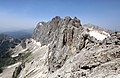
Next, reefs began to develop in the shallow waters of the sea, in which small coralline algae (haptophytes) and corals lived. Their dead, limy skeletons form the most important rock: Wetterstein limestone. This mostly bright white and weather-resistant limestone contrasts strongly with the other rocks. It forms the striking summits of the Mieminger and Wetterstein Mountains, not least the Sonnenspitze, Igelskopf and Zugspitze. Because Wetterstein limestone contains few plant nutrients, its scree and talus slopes are largely unvegetated and this tends to characterise the scene above the tree line.

A feature of Wetterstein limestone is silver-containing lead and zinc ore. These were mined at Silberleithe and in the rest of the Mieminger Mountains. The Triassic Period in the Mieminger Chain ends with Wetterstein limestone and is then followed by the Jurassic whose deposits are of less importance. They were largely carried off in the course of the millions of years and only still exist in a few sheltered sites or underground.

Alpine Orogeny

At the time of their deposition the rocks of the Northern Limestone Alps were located several hundred kilometres south of their present position. About 35 million years ago, tectonic forces, that are still active today, began to push these geological units northwards. At that time several kilometres of rock and several hundred metres of water lay on top of the rocks visible today. As a result there was a massive overlapping pressure that prevented the formations underneath from breaking up as they were pushed together.

As a result of the compressional forces, thrust faulting occurred piling the rock layers up into nappes (Gesteinsdecken). For example, the steep slopes falling away from the Mieminger Mountains into the Ehrwald Basin or the Leutasch River are the front of such a nappe, also called the Inn Valley Stack (Inntaldecke). At the same time the rocks were uplifted. Taken together these processes are referred to as orogeny or mountain building.

Ice ages

The relatively recent deposits in the up to 70 metre deep moors are predominantly gravels, shingles, clay, humus and peat; the latter even being used at one time near Lermoos for the lead-zinc smelter of the Silberleithen cooperative (Gewerkschaft). The finishing touches to the mountains and valleys took place during the Würm glaciation. The ice sheet of the Loisach Glacier was about 1,000 metres thick and, after the ice had melted about 10,000 years ago, it left behind that typical feature of ice age terrain: moraines. The remnants of the ice sheet in the mountains formed classic cirques, in which the last moraines of the glacier have survived.

The major change to the landscape since the last ice age was the Fern Pass landslide that filled the valley between Biberwier and Nassereith to a depth of 200 metres. Since then the scenery has changed very little. Occasionally there are rock avalanches, landslides or mudflows. Water, ice and wind continue to attack the rocks, transporting their debris down the mountain torrents into the valleys and reminding us that these geological processes continue today.

Neighbouring ranges

The Mieminger Chain borders on the following other mountain ranges of the Alps:

In the AVE, the Alpine Club classification of the Eastern Alps, published in 1984, the Mieminger and Wetterstein ranges are shown as a single unit.

Boundaries

To the south the River Inn forms the boundary of the range from the Niederbach stream near Inzing upstream as far as its confluence with the Gurglbach near Imst. Its western boundary runs along the Gurgltal valley from Imst to Nassereith and over the Fern Pass to Ehrwald. To the north its boundary runs from Ehrwald along the Gaisbach stream and the Ehrwalder Alm into the Gaistal (Leutascher Ache) and continues through Leutasch–Oberweidach and past the Simmelberg to the north to the Drahnbach. The eastern boundary runs along the stream of Drahnbach and over the Seefelder saddle, then downhill along the Niederbach to its confluence with the Inn.

The Fern Pass links the Mieminger range with the Lechtal Alps. The unnamed saddle near the Ehrwalder Alm is the link between the Mieminger Chain and the Wetterstein. The Seefelder saddle links the Mieminger Chain with the Karwendel.

Sub-divisions

The Alpine Club Guide divides the Mieminger Chain into the following sub-groups:

Peaks

The Ehrwalder Sonnenspitze (2,412 m) from the Coburger Hut Ehrwalder Sonnenspitze von Coburger Huette HQ.jpg
The Ehrwalder Sonnenspitze (2,412 m) from the Coburger Hut
The Hochplattig (2,768 m) and Hochwand (2,719 m) from the Hohe Munde Blick von Munde nach Westen HQ.jpg
The Hochplattig (2,768 m) and Hochwand (2,719 m) from the Hohe Munde

The 10 highest peaks in the Mieminger Chain are the:

In the Mieminger Mountains there are over 60 named peaks with spot heights. The best known, in order of height, are the:

In the area of the 1,789 m high Marienbergjoch is a ski area.

Tourism

Huts

There are three Alpine Club huts in the Mieminger Mountains, only one of which is managed.

Long-distance trails

The Via Alpina, a cross-border long-distance trail with five sections through the whole Alps, runs through the Mieminger Mountains.

The Red Path (Rote Weg) of the Via Alpina has two stages running through the range as follows:

Related Research Articles

<span class="mw-page-title-main">Geology of the Alps</span> The formation and structure of the European Alps

The Alps form part of a Cenozoic orogenic belt of mountain chains, called the Alpide belt, that stretches through southern Europe and Asia from the Atlantic all the way to the Himalayas. This belt of mountain chains was formed during the Alpine orogeny. A gap in these mountain chains in central Europe separates the Alps from the Carpathians to the east. Orogeny took place continuously and tectonic subsidence has produced the gaps in between.

<span class="mw-page-title-main">Karwendel</span> Mountain range of the Northern Limestone Alps

The Karwendel is the largest mountain range of the Northern Limestone Alps. It is located on the Austria–Germany border. The major part belongs to the Austrian federal state of Tyrol, while the adjacent area in the north is part of Bavaria, Germany. Four chains stretch from west to east; in addition, there are a number of fringe ranges and an extensive promontory (Vorkarwendel) in the north.

<span class="mw-page-title-main">Tux Alps</span> Subgroup of Austrian Central subgroup of Eastern Alps, Central Europe

The Tux Alps or Tux Prealps are a sub-group of the Austrian Central Alps, which in turn form part of the Eastern Alps within Central Europe. They are located entirely within the Austrian federal state of Tyrol. The Tux Alps are one of three mountain ranges that form an Alpine backdrop to the city of Innsbruck. Their highest peak is the Lizumer Reckner, 2,886 m (AA), which rises between the glen of Wattentaler Lizum and the valley of the Navisbach. Their name is derived from the village of Tux which is tucked away in a side valley of the Zillertal.

<span class="mw-page-title-main">Austroalpine nappes</span> Geological formation in the European Alps

The Austroalpine nappes are a geological nappe stack in the European Alps. The Alps contain three such stacks, of which the Austroalpine nappes are structurally on top of the other two. The name Austroalpine means Southern Alpine, because these nappes crop out mainly in the Eastern Alps.

<span class="mw-page-title-main">Allgäu Alps</span> Mountain range in the Northern Limestone Alps

The Allgäu Alps are a mountain range in the Northern Limestone Alps, located on the Austria–Germany border, which covers parts of the German states of Bavaria and Baden-Württemberg and the Austrian states of Tyrol and Vorarlberg. The range lies directly east of Lake Constance.

<span class="mw-page-title-main">Wetterstein</span> Mountain group in the Northern Limestone Alps

The Wetterstein mountains, colloquially called Wetterstein, is a mountain group in the Northern Limestone Alps within the Eastern Alps, crossing the Austria–Germany border. It is a comparatively compact range located between Garmisch-Partenkirchen, Mittenwald, Seefeld in Tirol and Ehrwald along the border between Germany (Bavaria) and Austria (Tyrol). Zugspitze, the highest peak is at the same time the highest mountain in Germany.

<span class="mw-page-title-main">Kaiser Mountains</span> Mountain range in Tyrol, Austria

The Kaiser Mountains are a mountain range in the Northern Limestone Alps and Eastern Alps. Its main ridges – are the Zahmer Kaiser and south of it the Wilder Kaiser. The mountains are situated in the Austrian province of Tyrol between the town of Kufstein and the town of St. Johann in Tirol. The Kaiser Mountains offer some of the loveliest scenery in all the Northern Limestone Alps.

<span class="mw-page-title-main">Schneefernerkopf</span>

The Schneefernerkopf is a 2,875-metre-high (9,432 ft) peak in the Zugspitze massif in the Alps. It lies at the western end of the Wetterstein chain in the Alps on the border between the German state of Bavaria and the Austrian state of Tyrol. It is the dominant mountain in the Wetterstein, especially when viewed from Ehrwald.

<span class="mw-page-title-main">Ammergau Alps</span> Mountain range in the states of Bavaria, Germany and Tyrol, Austria

The Ammergau Alps are a mountain range in the Northern Limestone Alps in the states of Bavaria (Germany) and Tyrol (Austria). They cover an area of about 30 x 30 km and begin at the outer edge of the Alps. The highest summit is the Daniel which has a height of 2,340 metres (7,680 ft).

<span class="mw-page-title-main">Seebensee</span>

The Seebensee is a natural high mountain lake at a height of 1,657 metres, south of Ehrwald in the Mieming Range. It is surrounded by the Vorderer Tajakopf in the east, the Vorderer Drachenkopf in the south and the Ehrwalder Sonnenspitze in the west.

<span class="mw-page-title-main">Hohe Munde</span>

The Hohe Munde is a 2,662-metre-high (8,734 ft) mountain at the eastern end of the Mieming Chain in the Austrian state of Tyrol. It has two peaks: the west top (2,662 m) and the east top or Mundekopf (2,592 m).

<span class="mw-page-title-main">Seefeld Saddle</span>

The Seefeld Saddle is a saddle and mountain pass, 1,185 m (AA), in the Northern Limestone Alps in the Austrian federal state of Tyrol. Two major transport routes run over it: the Seefelder Straße (B 177) and the Mittenwald Railway. On the Seefeld Plateau north of the saddle lies the village and ski resort of Seefeld in Tirol.

<span class="mw-page-title-main">Hochplattig</span> Mountain in Austria

The Hochplattig is a mountain, 2,768 m (AA) high, and the highest summit in the Mieming Chain, a mountain range in the Northern Limestone Alps in the state of Tyrol, Austria.

<span class="mw-page-title-main">Daniel (mountain)</span>

The Daniel is a mountain in the Austrian state of Tyrol, and the highest peak in the Ammergau Alps, a range within the Northern Limestone Alps . Located near the villages of Ehrwald and Lermoos, it is a popular mountain with hikers. Its North Face is around 200 metres high and its South Face has a more schrofen-like character. With the almost equally high Upsspitze (2,332 m) it forms a double summit. To the northwest is a neighbouring peak, the Hochschrutte (2,247 m).

<span class="mw-page-title-main">Kellenspitze</span>

The Kellenspitze, often also called the Kellespitze or Köllenspitze, at 2,238 m (AA) is the highest peak in the Tannheim Mountains. It lies in the Austrian state of Tyrol. Originally the mountain was known locally as the Metzenarsch, but when in 1854 Marie Frederica of Prussia visited the hunting lodge on the Tegelberg and was having the surrounding peaks pointed out, they called it after In der Kelle, the name of a strip of land at the foot of the mountain, because its original name referred to a Matz, in other words a prostitute, and seemed inappropriate.

<span class="mw-page-title-main">Gehrenspitze (Allgäu Alps)</span>

At 2,163 metres, the Gehrenspitze is the third highest mountain in the Tannheim Group and is situated in the Austrian state of Tyrol. It should not be confused with the Gehrenspitze in the Wetterstein Mountains.

<span class="mw-page-title-main">Vorderer Tajakopf</span>

The Vorderer Tajakopf is a 2,450-metre-high mountain in the Mieming Chain in the Austrian state of Tyrol.

<span class="mw-page-title-main">Ehrwalder Sonnenspitze</span>

The Sonnenspitze, also Ehrwalder Sonnenspitze, is a mountain, 2,417 m (AA) high, in the Mieming Chain in the Austrian state of Tyrol with a subpeak, the Signalgipfel (2,412 m) to the south. An ascent of the Sonnenspitze is one of the most popular tours of the Mieming Chain.

<span class="mw-page-title-main">Coburger Hut</span>

The Coburger Hut is an Alpine hut owned by the Coburg Branch of the German Alpine Club. It is located in the Mieming Range in the Austrian state of Tyrol and lies only a few metres in height above the lake of Drachensee. The accommodation is generally open from June to early October and there is a winter room.

<span class="mw-page-title-main">Hinterer Tajakopf</span>

The Hinterer Tajakopf is a mountain, 2,408 metres high, in the Mieming Range in the Austrian state of Tyrol.

References