Wannig

Last updated
Wannig
Wannig nassereith.jpg
Wannig (the lower peak on the right) seen from the Nassereither Alm
Highest point
Elevation 2,493  m (AA) (8,179 ft)
Prominence 704 m (2,310 ft) [1]
Coordinates 47°20′15″N10°51′45″E / 47.3375°N 10.8625°E / 47.3375; 10.8625
Geography
Alps location map.png
Red triangle with thick white border.svg
Wannig
Location in the Alps
Location Tyrol, Austria
Parent range Mieming Chain
Geology
Type of rock Wetterstein limestone
Climbing
First ascent first recreational ascent: L. Höß, G. Beyrer on 28 August 1894 via the Handschuhspitzen
Normal route Fern Pass – Nassereither Alm – Wannig

The Wannig (also Hochwannig or Wanneck) is a 2,493-metre-high mountain in the Mieming Chain in the Austrian state of Tyrol.

Contents

Location

The Wannig forms the western end of the Mieming Range. To the southwest lies the village of Nassereith in the Gurgltal valley, to the south is the Holzleiten Saddle that links the Gurgltal with the Mieming Plateau. To the north lies the Fern Pass, a crossing from the Gurgltal to Biberwier in the Ehrwald Basin. To the east the Mieming Chain continues with the Handschuhspitzen and the Marienbergjoch (1,789 m).

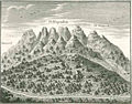
The upper 400m of the Wannig are characterised by crags and boulder fields, below which is a wide belt of mountain pine. In the lower regions of its western and southern slopes are the remains of old mine workings. Here in the Feigenstein Field (Revier Feigenstein), lead and zinc ore (Smithsonite) was mined.

Ascents

The Wannig is usually climbed from the Nassereither Alm (1,718 m, also called the Muthenaualm) to the northwest, which can be reached from the Fern Pass, from Albangerle north of Nassereith, from Biberwier or from the Marienbergjoch. This route runs across the western flank, the Green Wanne (Grüne Wanne), to the summit (UIAA grade I in places). Another route from Nassereith meets this path at a height of about 1,780 m.

From the Marienbergjoch the Wannig can be climbed from the Handschuhspitzen (UIAA I); other ascents along the north arête (UIAA I) and the north face (UIAA III) are rarely used.

Literature

Rudolf Wutscher (1989), Österreichischer Alpenverein; Deutscher Alpenverein; Alpenverein Südtirol (eds.), Alpenvereinsführer Mieminger Kette (in German), München: Bergverlag Rudolf Rother, pp. 160–161, ISBN   3-7633-1099-1

Related Research Articles

The Bezirk Imst is an administrative district (Bezirk) in Tyrol, Austria. It borders the district Reutte in the north, as well as sharing a small border with Bavaria (Germany). It borders the district Innsbruck-Land in the east, South Tyrol (Italy) in the south, and the district Landeck in the west.

<span class="mw-page-title-main">Fern Pass</span> Mountain pass in Tirol, Austria

Fern Pass is a mountain pass in the Tyrolean Alps in Austria. It is located between the Lechtal Alps on the west and the Mieming Mountains on the east. The highest peak in Germany, the Zugspitze is only 13.5 km away to the northeast. The pass lies between the Grubigstein on the northwest, the Wannig on the southeast, and the Loreakopf on the west.

<span class="mw-page-title-main">Wetterstein</span> Mountain group in the Northern Limestone Alps

The Wetterstein mountains, colloquially called Wetterstein, is a mountain group in the Northern Limestone Alps within the Eastern Alps, crossing the Austria–Germany border. It is a comparatively compact range located between Garmisch-Partenkirchen, Mittenwald, Seefeld in Tirol and Ehrwald along the border between Germany (Bavaria) and Austria (Tyrol). Zugspitze, the highest peak is at the same time the highest mountain in Germany.

<span class="mw-page-title-main">Hochvogel</span>

The Hochvogel is a 2,592-metre-high (8,504 ft) mountain in the Allgäu Alps. The national border between Germany and Austria runs over the summit. Although only the thirteenth highest summit in the Allgäu Alps, the Hochvogel dominates other parts of Allgäu Alps and the other ranges in the immediate neighbourhood. This is due to the fact that the majority of the higher peaks are concentrated in the central and western part of the Allgäu Alps. The Hochvogel stands on its own in the eastern part of the mountain group; the nearest neighbouring summits are 200 to 300 metres lower. Experienced climbers can ascend the summit on two marked routes.

<span class="mw-page-title-main">Östliche Karwendelspitze</span>

The Östliche Karwendelspitze (2,537 m) is a mountain formed from Wetterstein limestone in the Karwendel mountains on the border between Bavaria and Tyrol. It is the highest mountain of the Northern Karwendel chain and the highest German peak in the Karwendel. It was first climbed by Hermann von Barth on 4 July 1870.

<span class="mw-page-title-main">Mieming Range</span>

The Mieming(er) Range, Mieminger Chain or Mieminger Mountains, is a mountain range of the Northern Limestone Alps in the Eastern Alps. It is located entirely in Austria within the state of Tyrol. This sub-group is somewhat in the shadows of its more famous neighbour, the Wetterstein to the north. Whilst the region around the Coburger Hut and the lakes of Seebensee and Drachensee in the west and the Hohe Munde in the extreme east receive large numbers of visitors, the less developed central area remains very quiet. The Hohe Munde is also a popular and challenging ski touring destination.

<span class="mw-page-title-main">Schrammacher</span>

The Schrammacher is a mountain in the Austrian state of Tyrol. At 3,410 or 3,411 m it is, after the Olperer, the second highest peak of the Tux ridge of the Zillertal Alps. With its horn shape and its steep and smooth northwest wall the mountain is imposing from several directions.

<span class="mw-page-title-main">Hohe Munde</span>

The Hohe Munde is a 2,662-metre-high (8,734 ft) mountain at the eastern end of the Mieming Chain in the Austrian state of Tyrol. It has two peaks: the west top (2,662 m) and the east top or Mundekopf (2,592 m).

<span class="mw-page-title-main">Hochplattig</span> Mountain in Austria

The Hochplattig is a mountain, 2,768 m (AA) high, and the highest summit in the Mieming Chain, a mountain range in the Northern Limestone Alps in the state of Tyrol, Austria.

The Mieming Plateau is a mountain terrace between 850 and 1000 metres high above the Upper Inn valley in the Austrian state of Tyrol at the southern foot of the Mieming Chain. It lies in the municipalities of Wildermieming, Mieming, Obsteig and Mötz.

<span class="mw-page-title-main">Holzleiten Saddle</span>

The Holzleiten Saddle is a mountain pass between Nassereith and Obsteig in the Austrian state of Tyrol. The B 189 runs over the saddle and is about 25 km long. It is the only important and very busy link from the Inn valley to the Fern Pass. Whilst it ascends gradually in the east over the Mieming Plateau, the saddle drops relatively steeply in the west into the Gurgltal. Its maximum gradient is 12 %.

<span class="mw-page-title-main">Großer Bärenkopf</span>

The Große Bärenkopf or Weißer Bärenkopf is a twin-topped mountain in the Glockner Group in the Fuscher/Kapruner Kamm of the High Tauern, a range in the Austrian Central Alps. The mountain lies exactly on the border between the states of Salzburg and Carinthia.

<span class="mw-page-title-main">Großer Geiger</span>

The Großer Geiger, formerly also called the Obersulzbacher Venediger and Heiliggeistkogel, is a mountain, 3,360 m (AA), in the Venediger Group in the main chain of the Central Tauern. This chain lies in the High Tauern, part of the Austrian Central Alps on the border between the Austrian states of Tyrol in the south and Salzburg in the north.

<span class="mw-page-title-main">Schlieferspitze</span>

The Schlieferspitze is a mountain, 3,290 m (AA), on the ridge known as the Krimmler Kamm in the Venediger Group of the Alps. The ridge lies in the northwest of the High Tauern, part of the Austrian Central Alps in the Austrian federal state of Salzburg. The summit is the highest on the Krimmler Kamm and is described in the sources as one of the most attractive peaks in the Venediger Group. From the valleys of the Krimmler Achental to the southwest and the Obersulzbachtal to the northeast it appears as an extremely dominant mountain. Long and evenly formed arêtes, about two kilometres long, run from the summit to the northwest, northeast, southeast and southwest. The mountain was first ascended on 22 August 1871 by Eduard Richter, professor of geography at the University of Graz, and Johann Stüdl, a merchant from Prague and co-founder of the German Alpine Club.

<span class="mw-page-title-main">Hoher Seeblaskogel</span>

The Hoher Seeblaskogel is a mountain, 3,235 m (AA), in the western part of the Stubai Alps in the Austrian state of Tyrol. Its independent summit lies between the cols of Winnebachjoch and Bachfallenscharte. To the south the Grüne-Tatzen glacier climbs to just below the summit. The Seeblaskogel has rock faces on all sides, below which lie the glaciers of Ochsenkarferner to the north and Seeblaskogelferner to the east.

<span class="mw-page-title-main">Gleirscher Fernerkogel</span>

The Gleirscher Fernerkogel, also Gleirschfernerkogl, formerly called the Roßkarspitze, is a mountain, 3,189 m (AA), in the Southern Sellrain Mountains, a subgroup of the Stubai Alps. It rises in the Austrian state of Tyrol. The old name, Roßkarspitze, was given to it during the military survey of the region in the 1850s. The first documented ascent was undertaken on 1 September 1883 by Ludwig Purtscheller and Hans Schöller, a "professor from Salzburg". Purtscheller gave the mountain its present name. A prominent 500-metre-long ridge runs eastwards from the unimposing summit.

<span class="mw-page-title-main">Hexenkopf</span>

The Hexenkopf is a mountain, 3,035 m (AA), in the Samnaun Group in the Alps in the Austrian state of Tyrol.

<span class="mw-page-title-main">Babylonischer Turm</span>

The Babylonische Turm is a 2,060-metre-high rock needle on the eastern arête of the Kellenspitze (2,238 m), the highest summit in the Tannheim Mountains in the Austrian state of Tyrol. Seen from the south the pinnacle looks like an independent peak. It is important to Alpine climbers because it has numerous climbing routes.

<span class="mw-page-title-main">Ehrwalder Sonnenspitze</span>

The Sonnenspitze, also Ehrwalder Sonnenspitze, is a mountain, 2,417 m (AA) high, in the Mieming Chain in the Austrian state of Tyrol with a subpeak, the Signalgipfel (2,412 m) to the south. An ascent of the Sonnenspitze is one of the most popular tours of the Mieming Chain.

<span class="mw-page-title-main">Loreakopf</span>

The Loreakopf, also occasionally referred to as the Loreaspitze, is a mountain in the Lechtal Alps within the state of Tyrol, Austria.

References

  1. "Wannig - Peakbagger". peakbagger.com. Retrieved 2 February 2015.

Peter Simon. "Das Bergbaurevier Feigenstein". Kulturverein und Arbeitsgemeinschaft historischer Bergbau Nassereith. Retrieved 12 September 2008.
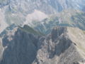