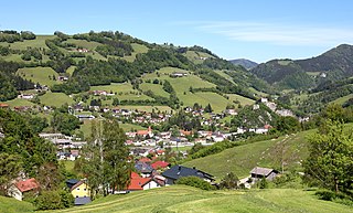
Losenstein is a small village in the south of Upper Austria, Austria. About 1,700 inhabitants call Losenstein their home. It lies in the southernmost quarter of Upper Austria called "Traunviertel". Its spatial dimension from North to South is 8,1 km, from West to East 4,5 km. 45,9% of its area are covered by forests, another 39,7% are used for agricultural purposes. The closest city of administrative importance is Steyr, which is 20 km to North. It can be accessed via the "B-109 Eisenbundesstrasse" or by train.

Lilienfeld is a city in Lower Austria (Niederösterreich), Austria, south of St. Pölten, noted as the site of Lilienfeld Abbey. It is also the site of a regional hospital Landesklinikum Voralpen Lilienfeld. The city is located in the valley of the Traisen River. Lilienfeld is in the province which the Ancient Romans called Noricum. Just a short distance past Lilienfeld Abbey, one can find the chair lift station that brings travelers to the top of Muckenkogel, a mountain in the Gutenstein Alps, at the height of 4,095 feet. On March 19, 1905, Muckenkogel was the site of the first official Alpine Ski Race, which was won by ski pioneer, Czech-born Mathias Zdarsky.
Erl is a municipality of 1,400 inhabitants in the Kufstein district in western Austria. It lies 15 km north of the administrative town of Kufstein in the northern part of the Tyrol, at the border with Bavaria, Germany.
Kirchbichl is a municipality in the Kufstein District in the Austrian state of Tyrol located 10 km south of Kufstein and 3 km northeast above Wörgl. It has six parts and its main source of income is cement industry.
Leutasch is a municipality in the northern part of the district Innsbruck-Land in the Austrian state of Tyrol about 30 km northwest of Innsbruck and 10 km northwest of Seefeld in Tirol

Scharnitz is a municipality in the district of Innsbruck-Land in the Austrian state of Tyrol located 16.4 kilometres (10.2 mi) north of Innsbruck and 9 kilometres (5.6 mi) from Seefeld in Tirol on the German border. It is one of the largest municipalities and has 10 parts: Au, Eisack, Gießenbach, Inrain, Jägerviertel, Oberdorf, Schanz, Schießstand, Siedlung, Unterdorf. The village was founded in the early Middle Ages and was once an important commercial route between Germany and Italy. The main source of income is tourism, both in summer and winter. Scharnitz is the western entry point to the Hinterau valley, where the source of river Isar is located.

Biberwier is a municipality with 612 inhabitants in the district of Reutte in the Austrian state of Tyrol. The municipality is located in the district court Reutte.

Bichlbach is a municipality in the district of Reutte in the Austrian state of Tyrol.

Obertraun, Upper Austria is a village in the Salzkammergut, a region in Austria, near the Hallstätter See and Hoher Dachstein. It is a popular holiday destination with activities such as skiing and snowboarding in the winter, and mountain biking, swimming and kayaking in the summer.

Holzgau is a municipality in the district of Reutte in the Austrian state of Tyrol.

Lermoos is a municipality in the district of Reutte in the Austrian state of Tyrol.

Haiming is a municipality and the name of its largest town, located in the district of Imst in the Austrian state of Tyrol.

Mieming is a municipality in the Imst district and is located 19 km east of Imst and 6 km west of Telfs. Main sources of income are agriculture and Summer tourism.

Henndorf am Wallersee, commonly named Henndorf, is a municipality of 5,025 inhabitants in the district of Salzburg-Umgebung in the state of Salzburg in Austria.

Atzenbrugg is a municipality in the district of Tulln in the Austrian state of Lower Austria. The composer Franz Schubert used to spend some time in Atzenbrugg in the summers around 1820.

Silz is a municipality in Austria in the Imst district. It is located 15 kilometres (9.3 mi) east of Imst and 11 kilometres (6.8 mi) west of Telfs. The ski resort Kühtai administratively belongs to the village area. Besides winter tourism, summer tourism, especially rafting on the Inn River, is also an important source of income for Silz.

Bürs is a municipality in the district of Bludenz in the Austrian state of Vorarlberg.

The Wetterstein mountains, colloquially called Wetterstein, is a mountain group in the Northern Limestone Alps within the Eastern Alps, crossing the Austria–Germany border. It is a comparatively compact range located between Garmisch-Partenkirchen, Mittenwald, Seefeld in Tirol and Ehrwald along the border between Germany (Bavaria) and Austria (Tyrol). Zugspitze, the highest peak is at the same time the highest mountain in Germany.

The Tyrolean Zugspitze Cable Car was the first wire ropeway to open the summit of the Zugspitze, Germany's highest mountain on the border of Austria. Designed and built by Adolf Bleichert & Co. of Leipzig, Germany, the system was a record-holder for the highest altitude.

The Schneefernerkopf is a 2,875-metre-high (9,432 ft) peak in the Zugspitze massif in the Alps. It lies at the western end of the Wetterstein chain in the Alps on the border between the German state of Bavaria and the Austrian state of Tyrol. It is the dominant mountain in the Wetterstein, especially when viewed from Ehrwald.


