Fieberbrunn is a market town in the Austrian state of Tyrol in the Kitzbühel district. It is located at 47°28′N12°33′E, in the Kitzbühel Alps. Fieberbrunn is the most populous municipality in the Pillerseetal valley.
Oberndorf is a municipality in Kitzbühel district in the Austrian state of Tyrol. It is located in the Leukental valley, on the Kitzbühler Ache stream, halfway between St. Johann in Tirol and Kitzbühel.
Walchsee is a municipality in the Austrian state of Tyrol in the Kufstein district. It is located in the lower Inn valley and belongs to the "Kaiserwinkl" and the "Untere Schranne".

Kilb is a town in the district of Melk in the Austrian state of Lower Austria.

Fritzens is a municipality in the district Innsbruck country in Tyrol (Austria). It lies 16 km east of Innsbruck on the left side of the Inn River. The Iron Age Fritzens-Sanzeno culture is named for archaeological finds from the village.

Going am Wilden Kaiser is a municipality in the district of Kitzbühel in the Austrian region of Sölllandl. It is located 8.5 km northwest of Kitzbühel and 5 km west of Sankt Johann in Tirol. The village has 1849 inhabitants and is divided into 5 sub-districts. Its main source of income is tourism. It is connected to the large Ski Welt skiing area by the Astbergbahn chairlift, which takes skiers rapidly from Going in the valley up to the large expanse of ski terrain on the mountainsides.
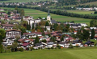
Kirchdorf in Tirol is a municipality in the Kitzbühel district in the Austrian state of Tyrol located 12.2 km (7.6 mi) north of Kitzbühel as well as 3 km (1.9 mi) north of Sankt Johann in Tirol at the Kitzbühler Ache. By area, Kirchdorf is the second largest municipality in the district. The village obtained its name from an old church which was built in the 8th century. The main sources of income are agriculture and tourism.

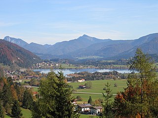
Kössen is a municipality in the Kitzbühel district in the Austrian state of Tyrol located 24 km north of Kitzbühel as well as 15.50 km north of Sankt Johann in Tirol at the Kitzbühler Ache near the border to Germany.

Ebbs is a municipality in the Kufstein district of Tyrol in Austria. The village is located in the Judicial district of Kufstein and in 2016 had a population of 5,480.

Scheffau am Wilden Kaiser is a municipality in the district Kufstein in the Austrian region of the Sölllandl. It is located 8.50 km southeast of Kufstein and 13 km northwest of Kitzbühel and has three subdivisions. The main source of income is summer tourism. The village has a public swimming area.
Söll is a municipality in the district of Kufstein in the Austrian region of Sölllandl. It is located 9 km south of Kufstein and 9 km east of Wörgl. The village consists of 25 subdivisions. The main sources of income are agriculture and tourism.

Sankt Gallenkirch is a municipality in the district of Bludenz in the Austrian state of Vorarlberg.

Höchst is a municipality in the district of Bregenz in the Austrian state of Vorarlberg.

Dünserberg is a municipality in the district of Feldkirch in the Austrian state of Vorarlberg.

Koblach is a municipality in the district of Feldkirch in the Austrian state of Vorarlberg.
Altschwendt is a municipality in the district of Schärding in the Austrian state of Upper Austria.
Pfaffing is a municipality in the district of Vöcklabruck in the Austrian state of Upper Austria.

Seewalchen am Attersee is a municipality in the district of Vöcklabruck in the Austrian state of Upper Austria.

Wundschuh is a municipality in the district of Graz-Umgebung in the Austrian state of Styria.
Sankt Ruprecht an der Raab is a market town with 5,421 residents in the district of Weiz in Styria, Austria. In the Styria municipal structural reform on 1 January 2015, the town was merged with the nearby towns Etzersdorf-Rollsdorf and Unterfladnitz.


