Ennstal Alps

Last updated
Ennstal Alps
German: Ennstaler Alpen
HochtorOedsteinGroup FromS HoherZinken.jpg
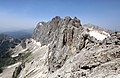
Hochtor - Ödstein Group (Gesäuse) (from right to left) as seen from Hoher Zinken in the south
Highest point
Peak Hochtor
Elevation 2,369 m (7,772 ft)
Coordinates 47°33′42″N14°37′50″E / 47.56167°N 14.63056°E / 47.56167; 14.63056
Geography
Alps location map (Ennstaler Alpen, AVE).png
Ennstal Alps (in red) within the Alps.
The borders of the range according to
Alpine Club classification of the Eastern Alps
Country Austria
States Styria and Upper Austria
Range coordinates 47°37′N14°35′E / 47.617°N 14.583°E / 47.617; 14.583
Parent range Northern Limestone Alps

The Ennstal Alps (German Ennstaler Alpen), the Alps of the Enns valley, are a mountain range of the Northern Limestone Alps System. They are located primarily in the Austrian state of Styria, and also into the state of Upper Austria.

Contents

The most famous scenery in the Ennstal Alps is the Gesäuse, a valley where the Enns river cuts through the limestone.

Geography

The Ennstal Alps range is defined by:

Peaks + mountain groups

Mountain groups that are part of the Ennstal Alps include:

Panoramic view of the Ennstal Alps. Pano sudlGesauseBerge.jpg
Panoramic view of the Ennstal Alps.

Gesäuse − Enns river valley

Gesause, the Enns river valley in the Ennstal Alps. Admont Weng Lauferbauerbrucke.JPG
Gesäuse, the Enns river valley in the Ennstal Alps.
View over the ridge of the Haller Mauern (Admonter Warte) to the Gesause Mountains. AdmonterWarteGesause.jpg
View over the ridge of the Haller Mauern (Admonter Warte) to the Gesäuse Mountains.

The Ennstal Alps range is pierced in the north by the Enns river. The Enns river valley name in German is Gesäuse. The valley is accompanied by the only roads and railway lines that run through the Ennstal Alps.

Adjacent mountain ranges

Other Alps mountain ranges that border on the Ennstal Alps include:

Settlements

Settlement within the range is restricted to the Gesäuse and several mountain valleys.

Towns in valleys around the perimeter of the range include: Leoben, Liezen, and Eisenerz.

See also

Commons-logo.svg Media related to Ennstaler Alpen at Wikimedia Commons

Related Research Articles

<span class="mw-page-title-main">Enns (river)</span> River in Austria

The Enns is a southern tributary of the river Danube, joining northward at Enns, Austria. It forms much of the border between the states of Lower Austria and Upper Austria. The Enns spans 253 kilometres (157 mi), in a flat-J-shape. It flows from its source near the village Flachau, generally eastward through Radstadt, Schladming, and Liezen, then turns north near Hieflau, to flow past Weyer and Ternberg through Steyr, and further north to the Danube at Enns.

<span class="mw-page-title-main">High Tauern</span> Mountain range of the eastern Alps

The High Tauern are a mountain range on the main chain of the Central Eastern Alps, comprising the highest peaks east of the Brenner Pass. The crest forms the southern border of the Austrian states of Salzburg, Carinthia and East Tyrol, with a small part in the southwest belongs to the Italian province of South Tyrol. The range includes Austria's highest mountain, the Grossglockner at 3,798 metres (12,461 ft) above the Adriatic.

<span class="mw-page-title-main">Tux Alps</span> Subgroup of Austrian Central subgroup of Eastern Alps, Central Europe

The Tux Alps or Tux Prealps are a sub-group of the Austrian Central Alps, which in turn form part of the Eastern Alps within Central Europe. They are located entirely within the Austrian federal state of Tyrol. The Tux Alps are one of three mountain ranges that form an Alpine backdrop to the city of Innsbruck. Their highest peak is the Lizumer Reckner, 2,886 m (AA), which rises between the glen of Wattentaler Lizum and the valley of the Navisbach. Their name is derived from the village of Tux which is tucked away in a side valley of the Zillertal.

<span class="mw-page-title-main">Geography of the Alps</span> Description of the landforms of the Alps mountain range

The Alps form a large mountain range dominating Central Europe, including parts of Italy, France, Switzerland, Liechtenstein, Austria, Slovenia, Germany and Hungary.

<span class="mw-page-title-main">Eastern Alps</span> Eastern part of the Alps mountain range

Eastern Alps is the name given to the eastern half of the Alps, usually defined as the area east of a line from Lake Constance and the Alpine Rhine valley, up to the Splügen Pass at the Alpine divide, and down the Liro River to Lake Como in the south. The peaks and mountain passes are lower than the Western Alps, while the range itself is broader and less arched.

<span class="mw-page-title-main">Lower Tauern</span>

The Lower Tauern or Niedere Tauern are a mountain range of the Central Eastern Alps, in the Austrian states of Salzburg and Styria.

<span class="mw-page-title-main">Gesäuse National Park</span> Austrian national park

The Gesäuse National Park is a national park in the Austrian state of Styria. Located in the mountainous Upper Styrian region, it covers large parts of the Gesäuse range within the Ennstal Alps and the steep water gap of the Enns river between Admont and Hieflau. The area also covers parts of the municipal areas of Johnsbach, Weng, Landl, and Sankt Gallen.

Bezirk Liezen is a district of the state of Styria in Austria. It is by far the largest district in Austria, about 1.2 times the size of the next district, and is divided into two "subdistricts": Bereich Liezen, and Expositur Gröbming. On December 31, 2011 the former third subdistrict Expositur Bad Aussee was abolished.

<span class="mw-page-title-main">Krems, Carinthia</span> Place in Carinthia, Austria

Krems in Kärnten is a municipality in the district of Spittal an der Drau in Carinthia in Austria.

<span class="mw-page-title-main">Hochtor</span>

Hochtor, at 2,369 m (7,772 ft), is the highest mountain in the Ennstaler Alps, part of the Northern Limestone Alps, in Styria, Austria.

<span class="mw-page-title-main">Gaishorn am See</span> Place in Styria, Austria

Gaishorn am See is a municipality in the district of Liezen in the Austrian state of Styria.

<span class="mw-page-title-main">Landl</span> Place in Styria, Austria

Landl is a municipality in the district of Liezen in the Austrian state of Styria.

<span class="mw-page-title-main">Dachstein Mountains</span> Mountain range in Austria

The Dachstein Mountains are a mountain range in the Northern Limestone Alps.

<span class="mw-page-title-main">Two-thousander</span>

Two-thousanders are mountains that have a height of at least 2,000 metres above sea level, but less than 3,000 metres. The term is used in Alpine circles, especially in Europe.

<span class="mw-page-title-main">Northern Styrian Alps</span>

The Northern Styrian Alps is the proposed name for a subdivision of mountain ranges in an as-yet-unadopted classification of the Alps located in Austria.

<span class="mw-page-title-main">Western Tauern Alps</span>

The Western Tauern Alps are a mountain range of the Central Eastern Alps.

<span class="mw-page-title-main">Gailtal Alps</span>

The Gailtal Alps, is a mountain range of the Southern Limestone Alps in Austria. It rises between the River Drava (Drau) and the Gail valley and through the southern part of East Tyrol. Its western group called "Lienz Dolomites", is sometimes counted as part of this range and sometimes seen as separate.

<span class="mw-page-title-main">Tauern</span> German word which originally meant high mountain pass in the Austrian Central Alps

The word Tauern is German and originally meant 'high mountain pass' in the Austrian Central Alps, referring to the many bridleways and passes of the parallel side valleys of the River Salzach that cut into the mountain ranges. From the Middle Ages, when mining reached its heyday, the word Tauern was also used to name the corresponding ranges. The name has survived in many local placenames today.

<span class="mw-page-title-main">Seckau Tauern</span>

The Seckau Tauern or Seckau Alps are a small subrange of the Low Tauern mountains in the Austrian Central Alps, part of the Eastern Alps. The range is located in the Austria state of Styria.

<span class="mw-page-title-main">Sölk</span> Place in Styria, Austria

Sölk is a municipality since 2015 in the Liezen District of Styria, Austria.

References