The Alps are the highest and most extensive mountain range system that lies entirely in Europe, stretching approximately 750 mi (1,210 km) across eight Alpine countries : France, Switzerland, Monaco, Italy, Liechtenstein, Austria, Germany, and Slovenia.

The Alpine region of Switzerland, conventionally referred to as the Swiss Alps, represents a major natural feature of the country and is, along with the Swiss Plateau and the Swiss portion of the Jura Mountains, one of its three main physiographic regions. The Swiss Alps extend over both the Western Alps and the Eastern Alps, encompassing an area sometimes called Central Alps. While the northern ranges from the Bernese Alps to the Appenzell Alps are entirely in Switzerland, the southern ranges from the Mont Blanc massif to the Bernina massif are shared with other countries such as France, Italy, Austria and Liechtenstein.
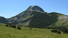
The Kamnik–Savinja Alps are a mountain range of the Southern Limestone Alps. They lie in northern Slovenia, except for the northernmost part, which lies in Austria.

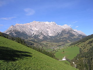
The Grossglockner is, at 3,798 metres above the Adriatic (12,461 ft), the highest mountain in Austria and the highest mountain in the Alps east of the Brenner Pass. It is part of the larger Glockner Group of the Hohe Tauern range, situated along the main ridge of the Central Eastern Alps and the Alpine divide. The Pasterze, Austria's most extended glacier, lies on the Grossglockner's eastern slope.

The Kitzbühel Alps are a mountain range of the Central Eastern Alps surrounding the town of Kitzbühel in Tyrol, Austria. Geologically they are part of the western slate zone.

The Stubai Alps is a mountain range in the Central Eastern Alps of Europe. It derives its name from the Stubaital valley to its east and is located southwest of Innsbruck, Austria. Several peaks form the border between Austria and Italy. The range is bounded by the Inn River valley to the north; the Sill River valley (Wipptal) and the Brenner Pass to the east ; the Ötztal and Timmelsjoch to the west, and to the south by tributaries of the Passer River and Eisack.

The Central Eastern Alps, also referred to as Austrian Central Alps or just Central Alps, comprise the main chain of the Eastern Alps in Austria and the adjacent regions of Switzerland, Liechtenstein, Italy and Slovenia. South them is the Southern Limestone Alps.

The Kreuzeck Group is a mountain range of the Central Eastern Alps. It may be considered either a separate range or part of the larger High Tauern chain. Administratively, the range belongs to the Austrian states of Carinthia and, in the westernmost part, Tyrol.

The Tux Alps or Tux Prealps are a sub-group of the Austrian Central Alps, which in turn form part of the Eastern Alps within Central Europe. They are located entirely within the Austrian federal state of Tyrol. The Tux Alps are one of three mountain ranges that form an Alpine backdrop to the city of Innsbruck. Their highest peak is the Lizumer Reckner, 2,886 m (AA), which rises between the glen of Wattentaler Lizum and the valley of the Navisbach. Their name is derived from the village of Tux which is tucked away in a side valley of the Zillertal.

The Alps cover a large area. This article describes the delimitation of the Alps as a whole and of subdivisions of the range, follows the course of the main chain of the Alps and discusses the lakes and glaciers found in the region.

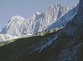
Eastern Alps is the name given to the eastern half of the Alps, usually defined as the area east of a line from Lake Constance and the Alpine Rhine valley up to the Splügen Pass at the Alpine divide and down the Liro River to Lake Como in the south. The peaks and mountain passes are lower than the Western Alps, while the range itself is broader and less arched.

The Radstadt Tauern are a subrange of the Central Eastern Alps in Austria. Together with the Schladming Tauern, the Rottenmann and Wölz Tauern and the Seckau Tauern the Radstadt Tauern form the major range of mountains known as the Low Tauern. The mountains are found in the southeast of the Austrian state of Salzburg, between the upper reaches of the Enns and Mur rivers.

The Allgäu Alps are a mountain range in the Northern Limestone Alps, located in Bavaria and Baden-Württemberg in Germany and Tyrol and Vorarlberg in Austria. The range lies directly east of Lake Constance.

The Weissensee is a lake in the Austrian state of Carinthia within the Gailtal Alps mountain range. The highest situated Carinthian bathing lake shares its name with the municipality of Weissensee on the northern and southern shore.
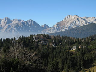
The Berchtesgaden Alps are a mountain range of the Northern Limestone Alps, named after the market town of Berchtesgaden located in the centre. The central part belongs to the Berchtesgadener Land district of southeastern Bavaria, Germany, while the adjacent area in the north, east and south is part of the Austrian state of Salzburg.

The Hochschwab, Hochschwab Mountains, Hochschwab Alps or Hochschwab Group is a mountain range in the Northern Limestone Alps of Austria. The range is in the Styria. The highest peak is also called Hochschwab and is 2,277 metres above the Adriatic.

The Gutenstein Alps are a mountain range in the Eastern Alps in Central Europe, and the northeasternmost part of the Northern Limestone Alps, reaching heights over 1,000 m.

The Alpine Club classification of the Eastern Alps is a common division of the Eastern Alps into 75 mountain ranges, based on the Moriggl Classification (ME) first published in 1924 by the German and Austrian Alpine Club. The present-day division established for the German-speaking world was compiled by the German, Austrian and South Tyrol Alpine Clubs and published in 1984 and is also used for the basic numbering of Alpine Club maps for mountaineering.

The Gurktal Alps are a mountain range of the Central Eastern Alps in Austria, named after the valley of the Gurk River.