Salzkammergut Mountains

Last updated
Salzkammergut Mountains
Sankt Gilgen und Wolfgangsee.JPG
View from Sankt Gilgen over Wolfgangsee
Highest point
PeakGamsfeld
Elevation 2,027 m (6,650 ft)
Coordinates 47°37′24″N13°28′50″E / 47.62333°N 13.48056°E / 47.62333; 13.48056
Geography
Country Austria
Region Salzburg, Upper Austria
Range coordinates 47°42′00″N13°35′00″E / 47.7°N 13.5833°E / 47.7; 13.5833 Coordinates: 47°42′00″N13°35′00″E / 47.7°N 13.5833°E / 47.7; 13.5833
Parent range Northern Limestone Alps
Salzkammergut and Upper Austria Alps

The Salzkammergut Mountains (German : Salzkammergut-Berge) are a mountain range of the Northern Limestone Alps, located in the Austrian states of Salzburg and Upper Austria. They are named after the Salzkammergut historic region, part of the Hallstatt-Dachstein / Salzkammergut Cultural Landscape UNESCO World Heritage Site.

Geography

According to the Alpine Club classification of the Eastern Alps, the Salzkammergut Mountains (AVE 17a) lie to the east of the Berchtesgaden Alps and the city of Salzburg.

To the north the Austrian Alpine Foreland is the boundary, between the points where the rivers Salzach and Traun spill out into the Foreland near Salzburg and Gmunden respectively. To the east the boundary with the Upper Austrian Prealps is formed by the Traun between the lakes of Traunsee and, further downstream, with the Totes Gebirge by the Lake Hallstatt on the foot of the Dachstein Mountains. To the south the border runs from Lake Hallstatt up the Gosau Valley to Gschütt Pass, and from there downhill along the Rußbach Valley, separating the Salzkammergut Mountains from the Tennengebirge in the southwest, and the Lammer creek to its confluence with the Salzach near Golling. To the west the boundary runs along the River Salzach from where it is joined by the Lammer down to the city of Salzburg.

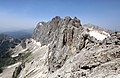
The highest peak with an elevation of 2,027 m (6,650 ft) is Mt. Gamsfeld near Gschütt Pass in the south, the only two-thousander of the range. The best-known mountain however is the prominent Schafberg 1,782 m (5,846 ft) on Wolfgangsee, with access to the summit provided by the Schafberg Railway.

See also

Related Research Articles

Salzburg (state) State of Austria

Salzburg is a state (Land) of Austria. It is officially named Land Salzburg, colloquially Salzburgerland, to distinguish it from its eponymous capital Salzburg city and as such is the only state to be named after its capital. By its centuries-long history as an independent Prince-Bishopric, Salzburg's tradition differs from the other Austrian lands.

Geography of Austria Overview of the geography of Austria

Austria is a small, predominantly mountainous country in Central Europe, approximately between Germany, Italy and Hungary. It has a total area of 83,879 km² (32,385 mi²), about twice the size of Switzerland.

Salzach River in Austria and Germany

The Salzach is a river in Austria and Germany. It is a right tributary of the Inn and is 227 kilometres (141 mi) in length, its flow eventually joins the Danube. Its drainage basin of 6,829 km2 (2,637 sq mi) comprises large parts of the Northern Limestone and Central Eastern Alps. 83% of its drainage basin lies in Austria, the remainder in Germany (Bavaria). Its largest tributaries are Lammer, Berchtesgadener Ache, Saalach, Sur and Götzinger Achen.

Salzkammergut

The Salzkammergut is a resort area located in Austria, stretching from the city of Salzburg eastwards along the Alpine Foreland and the Northern Limestone Alps to the peaks of the Dachstein Mountains. The main river of the region is the Traun, a right tributary of the Danube.

Kitzbühel Alps Mountain range in Austria

The Kitzbühel Alps are a mountain range of the Central Eastern Alps surrounding the town of Kitzbühel in Tyrol, Austria. Geologically they are part of the western slate zone.

Northern Limestone Alps

The Northern Limestone Alps, also called the Northern Calcareous Alps, are the ranges of the Eastern Alps north of the Central Eastern Alps located in Austria and the adjacent Bavarian lands of southeastern Germany. The distinction from the latter group, where the higher peaks are located, is based on differences in geological composition.

Central Eastern Alps Portion of the Eastern Alps mountain range through Austria and parts of surrounding countries

The Central Eastern Alps, also referred to as Austrian Central Alps or just Central Alps comprise the main chain of the Eastern Alps in Austria and the adjacent regions of Switzerland, Liechtenstein, Italy and Slovenia. Below it are the Southern Limestone Alps.

Hoher Dachstein

Hoher Dachstein is a strongly karstic Austrian mountain, and the second highest mountain in the Northern Limestone Alps. It is situated at the border of Upper Austria and Styria in central Austria, and is the highest point in each of those states. Parts of the massif also lie in the state of Salzburg, leading to the mountain being referred to as the Drei-Länder-Berg. The Dachstein massif covers an area of around 20×30 km with dozens of peaks above 2,500 m, the highest of which are in the southern and south-western areas. Seen from the north, the Dachstein massif is dominated by the glaciers with the rocky summits rising beyond them. By contrast, to the south, the mountain drops almost vertically to the valley floor.

Radstadt Tauern

The Radstadt Tauern are a subrange of the Central Eastern Alps in Austria. Together with the Schladming Tauern, the Rottenmann and Wölz Tauern and the Seckau Tauern the Radstadt Tauern form the major range of mountains known as the Low Tauern. The mountains are found in the southeast of the Austrian state of Salzburg, between the upper reaches of the Enns and Mur rivers.

Alpine foothills Index of articles associated with the same name

The Alpine foothills, or Prealps can refer generally to any foothills at the base of the European Alps. They are the transition zone between the High Alps to the Swiss Plateau and the Bavarian Alpine Foreland in the north, as well as to the Pannonian Basin (Alpokalja) in the east, the Padan Plain in the south and the Rhone Valley in the west.

Schafberg (Salzkammergut)

Schafberg is a mountain in the Austrian state of Salzburg. Situated within the Salzkammergut Mountains range of the Northern Limestone Alps, the Schafberg rises at the shore of Wolfgangsee Lake.

Berchtesgaden Alps

The Berchtesgaden Alps are a mountain range of the Northern Limestone Alps, named after the market town of Berchtesgaden located in the centre. The central part belongs to the Berchtesgadener Land district of southeastern Bavaria, Germany, while the adjacent area in the north, east and south is part of the Austrian state of Salzburg.

Salzburg Slate Alps

The Salzburg Slate Alps are a mountain range of the Eastern Alps, in the Austrian state of Salzburg. Situated within the greywacke zone, they could be regarded either as part of the Northern Limestone Alps or of the Central Eastern Alps.

Alpine Foreland

The Alpine Foreland, less commonly called the Bavarian Foreland, Bavarian Plateau or Bavarian Alpine Foreland, refers to a triangular region of plateau and rolling foothills in Southern Germany, stretching from Lake Constance in the west to beyond Linz on the Danube in the east, with the Bavarian Alps forming its south boundary and the Danube its northern extent.

Venediger Group

The Venediger Group is a mountain range of the Central Eastern Alps. Together with the Granatspitze Group, the Glockner Group, the Goldberg Group, and the Ankogel Group, it forms the main ridge of the High Tauern. The highest peak is the Großvenediger at 3,657 m (AA), which gives its name to the group. Considerable parts of the Venediger Group belong to the core zone of the High Tauern National Park.

Tennen Mountains

The Tennen Mountains is a small, but rugged, mountain range in the Northern Limestone Alps, which lies in front of the Eastern Alps for its entire length. It is a very heavily karstified high plateau, about 60 km² in area, with many caves. The range is located in Austria in the district of Salzburg near Bischofshofen.

Dachstein Mountains

The Dachstein Mountains are a mountain range in the Northern Limestone Alps.

Salzkammergut and Upper Austria Alps Mountain range in Austria

The Salzkammergut and Upper Austria Alps is the proposed name for a subdivision of mountains in a new classification of the Alps, which are located in Austria.

Western Tauern Alps

The Western Tauern Alps are a mountain range of the Central Eastern Alps.

Gosaukamm

The Gosaukamm is an Austrian mountain chain within the Dachstein range of the Northern Limestone Alps. Although relatively short in length, the chain forms an imposing backdrop to the valley and town of Gosau. Its highest point reaches an elevation of 2,458 metres (8,064 ft).