Lechtal Alps

Last updated
Lechtal Alps
German: Lechtaler Alpen
Parseierspitze.jpg
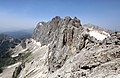
Parseierspitze with Grinner Glacier
Highest point
Peak Parseierspitze
Elevation 3,036 m (9,961 ft)
Coordinates 47°10′28″N10°28′42″E / 47.17444°N 10.47833°E / 47.17444; 10.47833 Coordinates: 47°10′28″N10°28′42″E / 47.17444°N 10.47833°E / 47.17444; 10.47833
Geography
Karte Lechtaler Alpen.png
Lechtal Alps
The borders of the range according to
Alpine Club classification of the Eastern Alps
Country Austria
States Tyrol and Vorarlberg
Parent range Northern Limestone Alps
Borders onAllgäu Alps and Ammergau Alps

The Lechtal Alps (German : Lechtaler Alpen) are a mountain-range in western Austria, and part of the greater Northern Limestone Alps range. Named for the river Lech which drains them north-ward into Germany, the Lechtal Alps occupy the Austrian states of Tyrol and Vorarlberg and are known for their diverse rock structure.

The Lechtal Alps are surrounded by the Ötztal Alps, Samnaun Alps and Verwall Alps (south) and the Allgäu Alps (north).

Peaks


Related Research Articles

Bavarian Alps

Bavarian Alps is a summarizing term of several mountain ranges of the Northern Limestone Alps in the German state of Bavaria.

Ötztal Alps

The Ötztal Alps are a mountain range in the Central Eastern Alps, in the State of Tyrol in southern Austria and the Province of South Tyrol in northern Italy.

Northern Limestone Alps Ranges of the Eastern Alps north of the Central Eastern Alps

The Northern Limestone Alps, also called the Northern Calcareous Alps, are the ranges of the Eastern Alps north of the Central Eastern Alps located in Austria and the adjacent Bavarian lands of southeastern Germany. The distinction from the latter group, where the higher peaks are located, is based on differences in geological composition.

Dawinkopf

Dawinkopf is a mountain in Tyrol, Austria. At an elevation of 2,970 metres (9,740 ft), it is the second-highest mountain of the Lechtal Alps and the third highest in the Northern Limestone Alps.

Ammergau Alps

The Ammergau Alps are a mountain range in the Northern Limestone Alps in the states of Bavaria (Germany) and Tyrol (Austria). They cover an area of about 30 x 30 km and begin at the outer edge of the Alps. The highest summit is the Daniel which has a height of 2,340 metres (7,680 ft).

Biberkopf Mountainin the Alps

The Biberkopf is a 2,599 m high mountain in the Alps on the border between Germany and Austria.

Hochfrottspitze

The Hochfrottspitze is a 2,649-metre-high (8,691 ft) mountain, made of main dolomite, in the Allgäu Alps near Oberstdorf in Germany and the highest German mountain in the Allgäu Alps. The border with Austria runs along its ridge.

Hochvogel

The Hochvogel is a 2,592-metre-high (8,504 ft) mountain in the Allgäu Alps. The national border between Germany and Austria runs over the summit. Although only the thirteenth highest summit in the Allgäu Alps, the Hochvogel dominates other parts of Allgäu Alps and the other ranges in the immediate neighbourhood. This is due to the fact that the majority of the higher peaks are concentrated in the central and western part of the Allgäu Alps. The Hochvogel stands on its own in the eastern part of the mountain group; the nearest neighbouring summits are 200 to 300 metres lower. Experienced climbers can ascend the summit on two marked routes.

Trettachspitze

The Trettachspitze is a 2,595-metre-high (8,514 ft) mountain in the Allgäu Alps in Germany. Due to its striking appearance it is one of the best-known mountains in the Allgäu Alps.

SOIUSA

SOIUSA is a proposal for a new classification system of the Alps from the geographic and toponomastic point of view. It was designed by Sergio Marazzi, Italian researcher and author of the Orographic Atlas of the Alps SOIUSA. His book was presented with the patronage of the Italian Alpine Club on 23 Jan 2006, but has yet to receive any formal acceptance.

Alpine Club classification of the Eastern Alps

The Alpine Club classification of the Eastern Alps is a common division of the Eastern Alps into 75 mountain ranges, based on the Moriggl Classification (ME) first published in 1924 by the German and Austrian Alpine Club. The present-day division established for the German-speaking world was compiled by the German, Austrian and South Tyrol Alpine Clubs and published in 1984 and is also used for the basic numbering of Alpine Club maps for mountaineering.

Hohes Licht

The Hohes Licht, at 2,651 metres, is the second highest mountain in the Allgäu Alps after the Großer Krottenkopf. Its summit lies in the Austrian state of Tyrol.

Fallenbacherspitze

The Fallenbacherspitze in the Austrian state of Tyrol is a 2,723-metre-high rock summit in the Lechtal Alps. Due to its remoteness and lack of signed routes, the mountain is not climbed very often.

Urbeleskarspitze

The Urbeleskarspitze is a 2,632-metre-high mountain peak in the Allgäu Alps. It lies within Austria in the state of Tyrol and is the fifth-highest summit in the Allgäu Alps and the second-highest peak in the Hornbach chain. Its neighbours in the Hornbach chain are the Bretterspitze to the southwest and the Zwölfer Spitze to the northeast.

Hornbach chain

The Hornbach chain is a string of mountains, about 15 kilometres long, in the Allgäu Alps in the Austrian state of Tyrol.

Vorderseespitze

The Vorderseespitze is a mountain in the Lechtal Alps, Tyrol, Austria. At 2,889 m (AA) it is the eighth highest peak in the Lechtal Alps. The Lech Valley Ridgeway runs over its southeastern flank from Kaiserjochhaus to the Ansbacher Hut. According to the literature it was first climbed in 1855 by locals from Kaisers in the Lech Valley.

Große Schlenkerspitze

The Große Schlenkerspitze is a mountain in the Lechtal Alps in the Austrian state of Tyrol. At 2,827 m (AA) or, according to other sources, 2,831 m, it is the highest peak in the eastern part of the Lechtal Alps.

Imster Muttekopf

The Muttekopf is a lookout mountain in the Lechtal Alps in the Austrian state of Tyrol. It lies northwest of Imst and immediately south of the Hahntennjoch saddle.

Loreakopf

The Loreakopf, also occasionally referred to as the Loreaspitze, is a mountain in the Lechtal Alps within the state of Tyrol, Austria.