
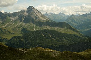
The Ammergau Alps are a mountain range in the Northern Limestone Alps in the states of Bavaria (Germany) and Tyrol (Austria). They cover an area of about 30 x 30 km and begin at the outer edge of the Alps. The highest summit is the Daniel which has a height of 2,340 metres (7,680 ft).
The Biberkopf is a 2,599 m high mountain in the Alps on the border between Germany and Austria.
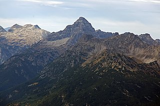
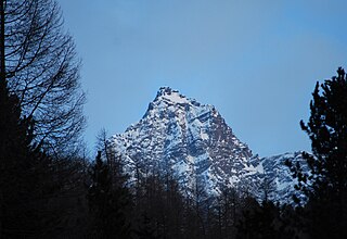
The Hochvogel is a 2,592-metre-high (8,504 ft) mountain in the Allgäu Alps. The national border between Germany and Austria runs over the summit. Although only the thirteenth highest summit in the Allgäu Alps, the Hochvogel dominates other parts of Allgäu Alps and the other ranges in the immediate neighbourhood. This is due to the fact that the majority of the higher peaks are concentrated in the central and western part of the Allgäu Alps. The Hochvogel stands on its own in the eastern part of the mountain group; the nearest neighbouring summits are 200 to 300 metres lower. Experienced climbers can ascend the summit on two marked routes.

The Mädelegabel is a 2,645 metre high mountain, made of main dolomite, in the Allgäu Alps near Oberstdorf. It is one of the best-known and most-climbed high peaks in the German Alps, Within the Allgäu Alps it is the fourth-highest summit, with rock faces up to 400 metres high. Together with the Trettachspitze and the Hochfrottspitze it forms the famous triumvirate of peaks on the main crest of the Allgäu. Its name comes from Mähder - a mown mountain pasture in the vicinity - and gabel from the appearance of the triumvirate to the north which recalls a fork. Originally the Mädelegabel was the name for all three peaks of the triumvirate; only later were they distinguished from one another by name.

The Großer Krottenkopf is the highest mountain in the Allgäu Alps of Austria. It is 2,656 m (AA) and is part of a side branch of the Hornbach chain, which branches off the main chain of the Allgäu Alps and runs for about 15 km eastwards.
The Hohes Licht, at 2,651 metres, is the second highest mountain in the Allgäu Alps after the Großer Krottenkopf. Its summit lies in the Austrian state of Tyrol.

The Fallenbacherspitze in the Austrian state of Tyrol is a 2,723-metre-high rock summit in the Lechtal Alps. Due to its remoteness and lack of signed routes, the mountain is not climbed very often.
The Urbeleskarspitze is a 2,632-metre-high mountain peak in the Allgäu Alps. It lies within Austria in the state of Tyrol and is the fifth-highest summit in the Allgäu Alps and the second-highest peak in the Hornbach chain. Its neighbours in the Hornbach chain are the Bretterspitze to the southwest and the Zwölfer Spitze to the northeast.

The Roggalspitze is a peak, 2,673 m (AA), in the Lechquellen Mountains, in the Austrian state of Vorarlberg. It is considered one of the most attractive climbing peaks in the range. The name of the mountain is derived from the Romansh word rocca, which means "rock" or "crag".
The Strahlkogel, at 3,288 m (AA), is the highest peak in the Larstiger Mountains, a subgroup of the Stubai Alps in the Austrian state of Tyrol. The Strahlkogel is also the highest mountain in the municipality of Umhausen. Its name comes from its great, white, light-reflecting, quartz layers, which allegedly cause the mountain to "radiate" (strahlen). It has the shape of a well-proportioned, steep and pointed pyramid. Ascending the Strahlkogel is difficult and it is thus only rarely visited, unlike the neighbouring 3,287-metre-high Breiter Grieskogel. The first ascent of the mountain was in 1833 by Peter Carl Thurwieser, but his route and the precise circumstances of the climb have not been passed on. On 28 August 1887 Ludwig Purtscheller and Fritz Drasch from Salzburg climbed the mountain. Their route led along the west arête. Today, this is the normal route and easiest way to reach the summit.

At 3,474 m (AA) the Ruderhofspitze is the fourth highest mountain in the Stubai Alps in Austria. It is part of the Alpein Mountains and lies in the Austrian state of Tyrol. As a result of its topographic isolation and good all-round views it is one of the most visited mountains in the Stubai. An almost two-kilometre-long arête, the Grawawand, runs away from the summit to the east. Less prominent ridges run south and northwestwards from the Ruderhofspitze. The peak was first ascended on 30 August 1864 by Karl Baedeker, Anton von Ruthner and mountain guides Pankraz Gleinser and Alois Tanzer.

The Marchspitze is a prominent summit, made of main dolomite, in the Hornbach chain of the Allgäu Alps. It is located 1.5 kilometres east of the much better known Großer Krottenkopf and is entirely on Austrian soil.

The Bretterspitze is a 2,608-metre-high summit in the Austrian state of Tyrol. It is part of the Hornbach chain in the Allgäu Alps. Its neighbouring peaks in the Hornbach chain are the Gliegerkarspitze to the west and the Urbeleskarspitze to the northeast. The broad summit block of the Bretterspitze is made of main dolomite.

The Großer Widderstein is a mountain, 2,533 m (AA), in the west Austrian state of Vorarlberg. Topographically it belongs to the Allgäu Alps. It is the highest peak in the subgroup of the Southeastern Walsertal Mountains.

The Kellenspitze, often also called the Kellespitze or Köllenspitze, at 2,238 m (AA) is the highest peak in the Tannheim Mountains. It lies in the Austrian state of Tyrol. Originally the mountain was known locally as the Metzenarsch, but when in 1854 Marie Frederica of Prussia visited the hunting lodge on the Tegelberg and was having the surrounding peaks pointed out, they called it after In der Kelle, the name of a strip of land at the foot of the mountain, because its original name referred to a Matz, in other words a prostitute, and seemed inappropriate.

The Kreuzkarspitze is a 2,587-metre-high Austrian mountain in the Hornbach chain of the Allgäu Alps.
The Zwieselbacher Rosskogel is a double peak in the northern Stubai Alps in the Austrian state of Tyrol. Its summit offers a sweeping panorama to the north because no other higher mountains impede the view. To the south, by contrast, the view is restricted by higher summits in the Stubai Alps. The first well known ascent took place on 23 August 1881 by Ludwig Purtscheller accompanied by chamois hunter Franz Schnaiter from Zirl.

The Rietzer Grießkogel is a mountain, 2,884 m (AA), and the highest peak in the Northern Sellrain Mountains, part of the Stubai Alps in the Austrian state of Tyrol. The summit is easily climbed on path no. 153. The first documented ascent was undertaken in 1829 by Innsbruck botanist, Andrä Sauter, a brother of Anton Sauter. As a result of its easy accessibility on well marked paths from Telfs in the Inn Valley and from the Sellrain Valley, it is a popular destination. Its name is derived from the village of Rietz at its northern foot in the district of Imst in the upper Inn valley.

The Große Schlenkerspitze is a mountain in the Lechtal Alps in the Austrian state of Tyrol. At 2,827 m (AA) or, according to other sources, 2,831 m, it is the highest peak in the eastern part of the Lechtal Alps.

The Muttekopf is a lookout mountain in the Lechtal Alps in the Austrian state of Tyrol. It lies northwest of Imst and immediately south of the Hahntennjoch saddle.

