Verwall Alps

Last updated
Verwall Alps
Hoher Riffler Verwall von Norden.jpg
Hoher Riffler
Highest point
Peak Hoher Riffler
Elevation 3,168 m (10,394 ft)
Coordinates 47°6′58″N10°22′16″E / 47.11611°N 10.37111°E / 47.11611; 10.37111 Coordinates: 47°6′58″N10°22′16″E / 47.11611°N 10.37111°E / 47.11611; 10.37111
Geography
Verwall Karte.png
Verwall Alps
The borders of the range according to
Alpine Club classification of the Eastern Alps
CountryAustria
States Vorarlberg and Tyrol
Parent range Central Eastern Alps
Borders on Samnaun Alps, Silvretta and Rätikon

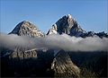
The Verwall Alps or Verwall Group [1] are a mountain range of the Central Eastern Alps at the border of the Austrian states of Tyrol and Vorarlberg.

It includes the following peaks (sorted by height):

For a list of passes, see Passes of the Silvretta and Rätikon Ranges

The Verwall Alps border on the Silvretta Alps in the west and on the Samnaun Alps in the south.

Related Research Articles

<span class="mw-page-title-main">Main chain of the Alps</span> Central line of mountains that forms the divide of the Alps

The main chain of the Alps, also called the Alpine divide is the central line of mountains that forms the drainage divide of the range. Main chains of mountain ranges are traditionally designated in this way, and generally include the highest peaks of a range. The Alps are something of an unusual case in that several significant groups of mountains are separated from the main chain by sizable distances. Among these groups are the Dauphine Alps, the Eastern and Western Graians, the entire Bernese Alps, the Tödi, Albula and Silvretta groups, the Ortler and Adamello ranges, and the Dolomites of South Tyrol, as well as the lower Alps of Vorarlberg, Bavaria, and Salzburg.

This article lists the principal mountain passes and tunnels in the Alps, and gives a history of transport across the Alps.

<span class="mw-page-title-main">Feldberg (Black Forest)</span> Mountain in the Black Forest, Baden-Württemberg, Germany

At 1,493 metres (4,898 ft) the Feldberg in the Black Forest is the highest mountain in Baden-Württemberg, and the highest in Germany outside of the Alps. The local municipality of Feldberg was named after the mountain.

<span class="mw-page-title-main">Silvretta Alps</span> Mountain in Italy

The Silvretta Alps are a mountain range of the Central Eastern Alps shared by Tirol, Vorarlberg and Graubünden (Switzerland). The Austrian states of Tirol and Vorarlberg are connected by a pass road. The majority of the peaks are elevated above three thousand metres and are surrounded by glaciers. Thus, the area is also known as the "Blue Silvretta".

<span class="mw-page-title-main">Rätikon</span> Mountain in Italy

The Rätikon is a mountain range of the Central Eastern Alps, located at the border between Vorarlberg, Liechtenstein and Graubünden. It is the geological border between the Eastern and Western Alps and stretches from the Montafon as far as the Rhine. In the south, the Prättigau is its limit, and in the north, it is the Walgau. In the east, it borders the Silvretta groups. The Rätikon mountain range derives its name from Raetia, a province of the Roman Empire, named after the Rhaetian people.

<span class="mw-page-title-main">Piz Buin</span> Alpine mountain peak

Piz Buin is a mountain in the Silvretta range of the Alps on the border between Austria and Switzerland. It forms the border between the Swiss canton of Graubünden and the Austrian state of Vorarlberg and is the highest peak in Vorarlberg.

<span class="mw-page-title-main">Samnaun Alps</span>

The Samnaun Alps are a mountain range of the Central Eastern Alps, named after the Swiss municipality of Samnaun. They are located at the border of the Austrian state of Tyrol and the Graubünden canton of Switzerland.

<span class="mw-page-title-main">Dreiländerspitze</span> Mountain in Switzerland

The Dreiländerspitze is one of the higher mountains in the Silvretta range in the eastern Alps, at 3,197 metres. The borders of Graubünden (Switzerland), Vorarlberg (Austria) and Tyrol (Austria) meet at the peak. Its name refers to a meeting point between the territories of three ancient tribes and their languages. It is also on the watershed between the Rhine and Danube. It is a favourite viewpoint, due to its position and accessibility. Its first documented ascent was by the German alpinist Theodor Petersen, accompanied by two locals, on 14 July 1870, although it appeared to have been previously climbed by surveyors in the 1850s. The nearest settlements are Galtür, 14 km to the north, and Guarda, 9 km to the south.

<span class="mw-page-title-main">Fluchthorn</span> Mountain in Switzerland

The Fluchthorn or Piz Fenga is a mountain in the Silvretta Alps, located on the border between Austria and Switzerland. With a height of 3,399 metres (11,152 ft) above sea level, it is the second highest summit of the Silvretta Alps. The Fluchthorn lies between the Jamtal (Tyrol) and the Val Fenga (Graubünden). It consists of three summits of which the southern one is the highest.

<span class="mw-page-title-main">Paznaun</span>

The Paznaun is a valley in Tyrol, Austria, leading south-west from Pians (856 m) to the Bielerhöhe (2071 m), a mountain pass at the border of Vorarlberg and Tyrol.

<span class="mw-page-title-main">Rhaetian Alps</span>

The Rhaetian Alps are a mountain range of the Eastern Alps. The SOIUSA classification system divides them into the Western and Eastern Rhaetian Alps, while the Alpine Club classification of the Eastern Alps places most of the Rhaetian subranges within the Western Limestone Alps.

<span class="mw-page-title-main">Eastern Alps</span> Eastern part of the Alps mountain range

Eastern Alps is the name given to the eastern half of the Alps, usually defined as the area east of a line from Lake Constance and the Alpine Rhine valley up to the Splügen Pass at the Alpine divide and down the Liro River to Lake Como in the south. The peaks and mountain passes are lower than the Western Alps, while the range itself is broader and less arched.

<span class="mw-page-title-main">Augstenberg</span> Mountain in Switzerland

The Augstenberg is a mountain of the Silvretta Alps, located on the border between Austria and Switzerland. It has an elevation of 3,230 metres (10,597 ft) above sea level. A secondary summit on the south has an elevation of 3,225 metres. On its eastern side the Augstenberg overlooks the Pass Futschöl.

<span class="mw-page-title-main">Lechtal Alps</span> Mountain range in Austria

The Lechtal Alps are a mountain-range in western Austria, and part of the greater Northern Limestone Alps range. Named for the river Lech which drains them north-ward into Germany, the Lechtal Alps occupy the Austrian states of Tyrol and Vorarlberg and are known for their diverse rock structure.

<span class="mw-page-title-main">Western Rhaetian Alps</span>

The Western Rhaetian Alps are a mountain range in the central part of the Alps.

<span class="mw-page-title-main">Fimbatal</span>

The Fimbatal, also Fimbertal, is an alpine valley situated between the Silvretta Alps and the Samnaun Alps. The valley is drained by the Fimbabach river, a tributary of the Inn basin (Trisanna) at Ischgl. The highest mountain bordering the Fimbatal is the Fluchthorn.

<span class="mw-page-title-main">Johann Jakob Weilenmann</span>

Johann Jakob Weilenmann was a Swiss mountaineer and Alpine writer.

<span class="mw-page-title-main">Val Sinestra</span>

The Val Sinestra is a valley of the Swiss Alps, located in the Engadin between the Silvretta and the Samnaun ranges. The valley is drained by La Brancla, a tributary of the Inn basin, near Ramosch. The highest mountains in the Val Sinestra are the Muttler, Piz Tschütta and Piz Tasna. The valley is approximately 10 kilometres long.

<span class="mw-page-title-main">Austria–Switzerland border</span> International border

The modern states of Austria and Switzerland share a border with a length of 180 km (110 mi) in two parts, separated by Liechtenstein, the longer stretch running across the Grison Alps and the shorter one following the Alpine Rhine to its mouth at Lake Constance.

References

  1. Reynolds, Kev (2005). Walking in the Alps, 2nd ed., Cicerone, Singapore, pp. 321-326. ISBN   1-85284-261-X.