Villgraten Mountains

Last updated
Villgraten Mountains
WeisseSpitzeRoteSpitzeVlgtnBg.jpg
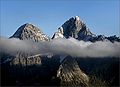
The two highest summits of the Villgraten Mountains, the Weiße Spitze (2,962 m, left) and Rote Spitze (2,956 m, right) seen from the Oberseitsee to the northwest (2,576 m)
Highest point
Peak Weiße Spitze
Elevation 2,962 m above sea level (AA)
Dimensions
Length44 km (27 mi)
Geography
Alps location map.png
Red triangle with thick white border.svg
Location of the Villgraten Mountains within the Eastern Alps
State East Tyrol, Trentino-South Tyrol
Range coordinates 46°52′18″N12°21′29″E / 46.87167°N 12.35806°E / 46.87167; 12.35806 Coordinates: 46°52′18″N12°21′29″E / 46.87167°N 12.35806°E / 46.87167; 12.35806
Parent range High Tauern

The Villgraten Mountains (German : Villgratner Berge) or Deferegg Alps (Deferegger Alpen), also called the Defreggen Mountains (Defreggengebirge, archaically also with "ff") are a subgroup of the Austrian Central Alps within the Eastern Alps of Europe. Together with the Ankogel Group, the Goldberg Group, the Glockner Group, the Schober Group, the Kreuzeck Group, the Granatspitze Group, the Venediger Group and the Rieserferner Group, the Villgraten Mountains are part of the major mountain range, the High Tauern. Their highest summit is the Weiße Spitze with a height of 2,962 m above sea level (AA).

Contents

Location

The Villgraten Mountains lie mainly in Austria, in the state of Tyrol, with a smaller element in Italy in the province of South Tyrol, in the region of Trentino-South Tyrol. They are located in the south of the High Tauern. Lienz, the regional capital of East Tyrol, is on the eastern side of the mountain range. Olang in the Puster Valley is located on the western side. Their name comes from the Villgraten Valley (Villgratental), which runs up into the mountains from the south.

The Villgraten Mountains are a peaceful backwater in many respects. There are no spectacular mountain peaks nor any comprehensive access with cable cars and roads. By contrast, the mountain hiker and nature lover can still find peace and quiet and enjoy nature in these mountains. The range is well known for a host of picturesquely situated mountain lakes, its rich plant life and the still relatively intact alpine pastures (Almmähder). The eponymous Villgraten Valley and its neighbour, the Gsies Valley to the west, are a ski touring paradise in winter.

Name

Range

The range was formally designated as the Villgraten Mountains (Villgratner Berge or Villgrater Berge) in the AVE, the Alpine Club classification of the Eastern Alps in 1984. This term is also used by the publisher, Bergverlag Rudolf Rother, the publishing house with the widest coverage of the Eastern Alps. On many maps, however, they are called the Defereggen Mountains (Defereggengebirge) or Gsies Mountains (Gsieser Berge).

The Defereggen valley is located on the northern edge of the mountain group. North of the valley is the Venediger Group. The Villgraten Valley, by contrast, is located entirely within the Villgraten Mountains. Consequently, the mountains are undoubtedly more logically named after this valley than after the Defereggental. In older classification systems of the Eastern Alps the Lasörling Group, north of the Defereggental, was counted as part of the Defereggen range. In earlier times the Defereggen valley would have been a suitable source of the name. Under the AVE, however, the Lasörling Group now belongs clearly to the Venediger Group.

Following the enforced annexation of South Tyrol after the First World War, the western part of the Villgraten Mountains ended up politically as part of Italy and was officially renamed the Monti di Casies. This was not a historically derived regional name, but a translation by Ettore Tolomei. German-speaking South Tyrolese frequently call them the Gsies Mountains (Gsieser Berge).

The term Villgraten Mountains is also historically and formally correct in referring to the entire mountain chain between the Hochstein east of Lienz and the Staller Saddle. Some maps use the name Defereggen Mountains (Defereggengebirge) for the eastern portion that lies within Austria, whilst labelling them the Gsieser Berge/Monti di Casies in the western portion that lies in Italy.

Highest summit

In the centre of the group rise two summits of almost equal height ( 46°52′18″N12°21′29″E / 46.87167°N 12.35806°E / 46.87167; 12.35806 and 46°52′34.86″N12°20′39.96″E / 46.8763500°N 12.3444333°E / 46.8763500; 12.3444333 ), called the Weiße Spitze and Rote Spitze ("White Peak" and "Red Peak"). The more easterly, with a height of 2,962 m above sea level (AA), is the highest point in the group. On that, all the maps and literature are agreed. However, the naming of the two summits is disputed. Whilst the majority of the Alpine literature, [1] the official maps [2] [3] and the inhabitants of the southern Villgraten valleys [4] call the higher, eastern summit the Weiße Spitze, and its lower, western, neighbour the Rote Spitze, it is referred to in the Defreggental, north of the mountains, and in one of the hiking books [5] [6] the other way around, thus naming the highest point as the Rote Spitze.

Because the sources do not agree on the naming of these peaks, the designation used by the Austrian Federal Office of Metrology and Surveying [2] is generally preferred. They confirm that the eastern summit is called the Weiße Spitze with a height of 2,962 m above sea level (AA) as the highest peak in the group.

Peaks

No peak in the Villgraten Mountains reaches the 3000 metre mark, but there are 20 summits higher than 2,800 m above sea level (AA) They are (sorted by height):

Valleys

Four larger valleys runs from the south into Villgraten Mountains: the uninhabited Wilfernertal, that descends to the village of Thal in the municipality of Assling, the likewise unpopulated Kristein, the Villgraten valley with its municipalities of Außervillgraten and Innervillgraten and the Gsieser valley in South Tyrol with its villages of Pichl, St. Magdalena and St. Martin. The Villgraten Mountains are bounded in the north by the Defereggen valley, in the east by the Iseltal, in the southeast by the Lienzer Talboden, in the south by the Puster valley and in the west by the Antholz Valley. Their boundary with Rieserferner Group is formed by the Staller Saddle. Of note is the Gsieser Törl within the Villgraten Mountains which acts as the transition from the South Tyrolean Gsies valley (Gsieser Tal) to the East Tyrolean Defereggen valley (Defereggental), which after the First World War until the 1970s was used as a smuggler's route between Austria and Italy.

Neighbouring mountain groups

The Villgraten Mountains border on the following other mountain groups of the Alps:

Huts

In the Villgraten Mountains there is an Alpine Club hut as well as several private huts and mountain cafes or (Jausenstationen):

Villgratner Berge.jpg
The Villgraten Mountains seen from the Defereggental with the Roter and Weißer Spitze

Related Research Articles

Kreuzeck group mountain range

The Kreuzeck Group is a mountain range of the Central Eastern Alps. It may be considered either a separate range or part of the larger High Tauern chain. Administratively, the range belongs to the Austrian states of Carinthia and, in the westernmost part, Tyrol.

High Tauern A mountain range of the eastern Alps

The High Tauern are a mountain range on the main chain of the Central Eastern Alps, comprising the highest peaks east of the Brenner Pass. The crest forms the southern border of the Austrian states of Salzburg, Carinthia and East Tyrol, with a small part in the southwest belongs to the Italian province of South Tyrol. The range includes Austria's highest mountain, the Grossglockner at 3,798 metres (12,461 ft) above the Adriatic.

The Bezirk Lienz is an administrative district (Bezirk) in Tyrol, Austria. It is the only district in East Tyrol. The district borders the Pinzgau (Salzburg) in the north, the districts Spittal an der Drau and Hermagor in the east, Veneto (Italy) in the south, and South Tyrol (Italy) in the west.

Puster Valley District in Italy

The Puster Valley is a valley in the Alps that runs in an east-west direction between Lienz in East Tyrol, Austria and Mühlbach near Brixen in South Tyrol, Italy. The South Tyrolean municipalities of the Puster Valley constitute the Puster Valley district.

Rasen-Antholz Comune in Trentino-Alto Adige/Südtirol, Italy

Rasen-Antholz is a municipality in South Tyrol in northern Italy.

Staller Saddle mountain pass in the eastern Alps

Staller Saddle, at 2,052 m (6,732 ft), is a high mountain pass in the High Tauern range of the Central Eastern Alps, connecting the Defereggen Valley in East Tyrol with the Antholz Valley in South Tyrol. The pass forms the border between Austria and Italy, it separates the Villgraten Mountains in the southeast from the Rieserferner Group in the northwest.

Glockner Group mountain range

The Glockner Group is a sub-group of the Austrian Central Alps in the Eastern Alps, and is located in the centre section of the High Tauern on the main chain of the Alps.

Venediger Group mountain range

The Venediger Group is a mountain range of the Central Eastern Alps. Together with the Granatspitze Group, the Glockner Group, the Goldberg Group, and the Ankogel Group, it forms the main ridge of the High Tauern. The highest peak is the Großvenediger at 3,657 m (AA), which gives its name to the group. Considerable parts of the Venediger Group belong to the core zone of the High Tauern National Park.

Granatspitze Group mountain range of the Austrian Alps

The Granatspitze Group, sometimes also the Granatspitz Group, is a sub-group of the Central Alps within the Eastern Alps. Together with the Ankogel Group, the Goldberg Group, the Glockner Group, the Schober Group, the Kreuzeck Group, the Venediger Group, the Villgraten Mountains and the Rieserferner Group, the Granatspitze Group forms the main range known as the High Tauern. The Granatspitze Group is located in Austria in the federal states of Salzburg and Tyrol. Its highest summit is the Großer Muntanitz, 3,232 m (AA)

Ankogel Group mountain range

The Ankogel Group is a sub-group of the Central Eastern Alps. Together with the Goldberg Group, the Glockner Group, the Schober Group, the Kreuzeck Group, the Granatspitze Group, the Venediger Group, the Villgraten Mountains and the Rieserferner Group it forms the mountain range of the Hohe Tauern.

Goldberg Group mountain range

The Goldberg Group is a sub-group of the Hohe Tauern mountain range within the Central Eastern Alps. It is located in Austria, in the states of Salzburg and Carinthia. Its highest peak is the Hocharn, 3,254 m (AA). Other well known summits are the Hoher Sonnblick, with its observatory at 3,106 m above sea level (AA), and the Schareck at 3,123 m above sea level (AA)

Weiße Spitze mountain

The Weiße Spitze, at a height of 2,962 m (AA), is the highest peak in the Villgraten Mountains. It lies south of St. Jakob in Defereggen and east of the Austro-Italian border.

Rote Spitze (Villgraten Mountains) mountain in the Villgratner Berge in East Tyrol

The Rote Spitze is a mountain in Austria and, at 2,956 m (AA), the second highest peak in the Villgraten Mountains. It lies south of St. Jakob in Defereggen and east of the Austro-Italian border.

Rote Spitze is the name of:

Rieserferner Group mountain range

The Rieserferner Group is a mountain range in the Austrian Central Alps. Together with the Ankogel Group, Goldberg Group, Glockner Group, Schober Group, Kreuzeck Group, Granatspitze Group, Venediger Group and the Villgraten Mountains the group is part of the High Tauern. The Rieserferner mountains extend across the Austrian state of Tyrol and the Italian province of South Tyrol. The mountains mainly lie in South Tyrol, where the greater part is protected within the Rieserferner-Ahrn Nature Park.

Nördlinger Hut building in Tyrol, Austria

The Nördlinger Hut is an Alpine Club hut belonging to the German Alpine Club that is situated at a height of 2,239 m (AA) south of the summit of the Reither Spitze in the Austrian state of Tyrol. It is thus the highest refuge hut in the entire Karwendel range. It is located in the westernmost part of the Karwendel Alps, the Erlspitze Group, above the village and ski resort of Seefeld. From the hut there are expansive views over the Stubai Alps, the Inn valley and the Wetterstein Mountains.

Hoher Eichham mountain in the Venediger Group in East Tyrol

The Hoher Eichham, at 3,371 m (AA), is the most dominant mountain in the southeastern part of the Venediger Group in the High Tauern in Austria. Four arêtes radiate from its summit towards the north, east, south and southwest. To the southeast is the glacier of Nilkees and, to the northeast, is the Hexenkees. The Großer Eichhamkees to the northwest and the Kleiner Eichhamkees to the southwest have shrunk to insignificant slabs of ice. On the North Arête is a rock tower, the Eichhamturm. Along the continuation of the arête lies the Großer Hexenkopf, which is roughly 600 metres as the crow flies from the Hoher Eichham. On the East Arête is the Niederer Eichham. From this subpeak a ridge branches southeast linking it with the Sailkopf; the lowest notch on this arête being the Sailscharte. The Hoher Eichham may have first been climbed during a military survey using triangulation in the 1850s. The first visit to the summit by tourists was on 16 July 1887 by Berlin alpinists, Carl Benzien and Hermann Meynow using the South Arête. They were led by the Zillertal mountain guide, Hans Hörhager, from Dornauberg.

Lasörling Group mountain range

The Lasörling Group is a subgroup of the Central Alps within the Eastern Alps. The boundaries of this mountain range in East Tyrol are principally delineated by the valleys of the Virgental in the north and the Defereggental in the south. According to the agreement by the Alpine clubs in 1984 the Lasörling Group is part of the Venediger Group, forming its southeastern part. In older classifications of the Eastern Alps, the Lasörling Group was counted as part of the Defereggen Mountains. The highest summit of the Lasörling Group is the Lasörling which gives the range its name. Sometimes the neighbouring Panargenkamm is also seen as part of the Lasörling group. Its highest mountain is the Keeseck.

Schlieferspitze mountain in Austria

The Schlieferspitze is a mountain, 3,290 m (AA), on the ridge known as the Krimmler Kamm in the Venediger Group of the Alps. The ridge lies in the northwest of the High Tauern, part of the Austrian Central Alps in the Austrian federal state of Salzburg. The summit is the highest on the Krimmler Kamm and is described in the sources as one of the most attractive peaks in the Venediger Group. From the valleys of the Krimmler Achental to the southwest and the Obersulzbachtal to the northeast it appears as an extremely dominant mountain. Long and evenly formed arêtes, about two kilometres long, run from the summit to the northwest, northeast, southeast and southwest. The mountain was first ascended on 22 August 1871 by Eduard Richter, professor of geography at the University of Graz, and Johann Stüdl, a merchant from Prague and co-founder of the German Alpine Club.

Rote Säule (Tauern) mountain in the Venediger Group at the border Salzburg / East Tyrol

The Rote Säule is a mountain, 2,993 m (AA), on the main chain of the Alps in the Venediger Group. It lies on the border between the Austrian states of Salzburg and East Tyrol.

References

  1. e.g. Walter Mayr (2006), East Tyrol Süd, Rother Wanderführer (in German), ISBN   3763341323
  2. 1 2 ÖK50
  3. Julian Pistotnik, "3.9.2. Defregger Alps", in Geologische Bundesanstalt Wien (ed.), The geologische Aufbau Austrias (in German), Wien, New York: Springer-Verlag, pp. 348–350, ISBN   3-211-81556-2 , retrieved 2011-04-30
  4. "The Villgraten valley" (PDF). p. 10. Retrieved 2011-04-30.
  5. Martin Gasser, Defreggental : Führer für Wanderer and Bergsteiger (PDF) (in German), retrieved 2011-04-30
  6. Gebietsführer "Defereggental"; Führer für Wanderer and Bergsteiger, von Martin Gasser, 184 Seiten, erschienen in the Selbstverlag, vgl. dort Seite 34 unten