
The Kreuzeck Group is a mountain range of the Central Eastern Alps. It may be considered either a separate range or part of the larger High Tauern chain. Administratively, the range belongs to the Austrian states of Carinthia and, in the westernmost part, Tyrol.

The High Tauern are a mountain range on the main chain of the Central Eastern Alps, comprising the highest peaks east of the Brenner Pass. The crest forms the southern border of the Austrian states of Salzburg, Carinthia and East Tyrol, with a small part in the southwest belongs to the Italian province of South Tyrol. The range includes Austria's highest mountain, the Grossglockner at 3,798 metres (12,461 ft) above the Adriatic.

The Radstadt Tauern are a subrange of the Central Eastern Alps in Austria. Together with the Schladming Tauern, the Rottenmann and Wölz Tauern and the Seckau Tauern the Radstadt Tauern form the major range of mountains known as the Low Tauern. The mountains are found in the southeast of the Austrian state of Salzburg, between the upper reaches of the Enns and Mur rivers.
Matrei in Osttirol is a market town in the Lienz District in the Austrian state of Tyrol. It is situated about 29 km (18 mi) north of Lienz within the Hohe Tauern mountain range of the Central Eastern Alps. Its municipal area comprises parts of the Granatspitze Group and the Venediger Group, with the Großvenediger peak as its highest point. The population largely depends on tourism, seasonal agriculture and forestry.

The Schober group is a sub-range of the Hohe Tauern mountains in the Central Eastern Alps, on the border between the Austrian states of Tyrol and Carinthia. Most of the range is located inside Hohe Tauern national park. It is named after Mt. Hochschober, 3,242 metres (10,636 ft), though its highest peak is Mt. Petzeck at 3,283 metres (10,771 ft).
The Salzburg Slate Alps are a mountain range of the Eastern Alps, in the Austrian state of Salzburg. Situated within the greywacke zone, they could be regarded either as part of the Northern Limestone Alps or of the Central Eastern Alps.

The Glockner Group is a sub-group of the Austrian Central Alps in the Eastern Alps, and is located in the centre section of the High Tauern on the main chain of the Alps.

The Venediger Group is a mountain range of the Central Eastern Alps. Together with the Granatspitze Group, the Glockner Group, the Goldberg Group, and the Ankogel Group, it forms the main ridge of the High Tauern. The highest peak is the Großvenediger at 3,657 m (AA), which gives its name to the group. Considerable parts of the Venediger Group belong to the core zone of the High Tauern National Park.
The Granatspitze is the mountain giving its name to the Granatspitze Group in the High Tauern, the Alpine backbone of Austria. This, despite the fact that several peaks in this group are actually higher, for example the Stubacher Sonnblick which is less than a kilometre to the north and two metres higher. But, unlike, its oft-climbed neighbour, the Granatspitze is more rarely frequented due to the level of difficulty of the ascent. The steep summit block of this striking peak is made of granite.

The Ankogel Group is a sub-group of the Central Eastern Alps. Together with the Goldberg Group, the Glockner Group, the Schober Group, the Kreuzeck Group, the Granatspitze Group, the Venediger Group, the Villgraten Mountains and the Rieserferner Group it forms the mountain range of the Hohe Tauern.

The Goldberg Group is a sub-group of the Hohe Tauern mountain range within the Central Eastern Alps. It is located in Austria, in the states of Salzburg and Carinthia. Its highest peak is the Hocharn, 3,254 m (AA). Other well known summits are the Hoher Sonnblick, with its observatory at 3,106 m above sea level (AA), and the Schareck at 3,123 m above sea level (AA)

The Villgraten Mountains or Deferegg Alps, also called the Defreggen Mountains are a subgroup of the Austrian Central Alps within the Eastern Alps of Europe. Together with the Ankogel Group, the Goldberg Group, the Glockner Group, the Schober Group, the Kreuzeck Group, the Granatspitze Group, the Venediger Group and the Rieserferner Group, the Villgraten Mountains are part of the major mountain range, the High Tauern. Their highest summit is the Weiße Spitze with a height of 2,962 m above sea level (AA).
The Rieserferner Group is a mountain range in the Austrian Central Alps. Together with the Ankogel Group, Goldberg Group, Glockner Group, Schober Group, Kreuzeck Group, Granatspitze Group, Venediger Group and the Villgraten Mountains the group is part of the High Tauern. The Rieserferner mountains extend across the Austrian state of Tyrol and the Italian province of South Tyrol. The mountains mainly lie in South Tyrol, where the greater part is protected within the Rieserferner-Ahrn Nature Park.

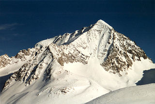
The Großer Muntanitz (3,232m) is the highest mountain in the Granatspitze Group, located between the Venediger Group and the Glockner Group in the High Tauern, Austria.

The Hoher Eichham, at 3,371 m (AA), is the most dominant mountain in the southeastern part of the Venediger Group in the High Tauern in Austria. Four arêtes radiate from its summit towards the north, east, south and southwest. To the southeast is the glacier of Nilkees and, to the northeast, is the Hexenkees. The Großer Eichhamkees to the northwest and the Kleiner Eichhamkees to the southwest have shrunk to insignificant slabs of ice. On the North Arête is a rock tower, the Eichhamturm. Along the continuation of the arête lies the Großer Hexenkopf, which is roughly 600 metres as the crow flies from the Hoher Eichham. On the East Arête is the Niederer Eichham. From this subpeak a ridge branches southeast linking it with the Sailkopf; the lowest notch on this arête being the Sailscharte. The Hoher Eichham may have first been climbed during a military survey using triangulation in the 1850s. The first visit to the summit by tourists was on 16 July 1887 by Berlin alpinists, Carl Benzien and Hermann Meynow using the South Arête. They were led by the Zillertal mountain guide, Hans Hörhager, from Dornauberg.

The Hoher Prijakt and Niederer Prijakt are a prominent double summit which, seen from the west and north, form one of the most attractively-shaped mountains of the Schober Group in the state of Tyrol in western Austria. The summit cross was placed on the lower Niederer Prijakt which is easier to see from the valley.

The Lasörling Group is a subgroup of the Central Alps within the Eastern Alps. The boundaries of this mountain range in East Tyrol are principally delineated by the valleys of the Virgental in the north and the Defereggental in the south. According to the agreement by the Alpine clubs in 1984 the Lasörling Group is part of the Venediger Group, forming its southeastern part. In older classifications of the Eastern Alps, the Lasörling Group was counted as part of the Defereggen Mountains. The highest summit of the Lasörling Group is the Lasörling which gives the range its name. Sometimes the neighbouring Panargenkamm is also seen as part of the Lasörling group. Its highest mountain is the Keeseck.

The Rote Knopf is the second highest mountain in the Schober Group within the High Tauern in the Austrian Alps. It is only two metres short of the Petzeck, the highest summit in the Schober. Nevertheless, this peak is far less well known that the Hochschober or the Glödis. This is probably because the mountain is not visible from the valleys of the Kalser Tal or the anterior Debanttal.

The Glödis is one of the most regularly formed summits in the Schober Group in East Tyrol, hence its sobriquet, the "Matterhorn of the Schober Group". It is an impressive sight both from the Debanttal valley and the valley of Kalser Lesachtal.

The Wangenitzsee Hut is a mountain hut in Hohe Tauern National Park, in Carinthia, Austria. It is situated directly on the Wangenitzsee, the largest lake of the Schober group of the Eastern Alps. At an altitude of 2,508 metres (8,228 ft) above sea level (AA), it is the highest hut in the Schober group. Depending on the weather, it opens in the middle of June and closes at the end of September. It is located on the Wiener Höhenweg, and is supplied by a material ropeway from the Debanttal.


