Ankogel Group

Last updated
Ankogel Group
Seebachtal Talschluss - Lassacher Winkel.jpg
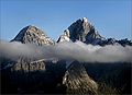
Seebach Valley near Mallnitz with Hochalmspitze
Highest point
PeakHochalmspitze
Elevation 3,360 m above sea level (AA)
Geography
Alps location map.png
Red triangle with thick white border.svg
Location within the Eastern Alps
Country Austria
States Carinthia and Salzburg
Range coordinates 47°00′57″N13°19′17″E / 47.01583°N 13.32139°E / 47.01583; 13.32139 Coordinates: 47°00′57″N13°19′17″E / 47.01583°N 13.32139°E / 47.01583; 13.32139
Parent range Western Tauern Alps
Hohe Tauern

The Ankogel Group (German : Ankogelgruppe) is a sub-group of the Central Eastern Alps. Together with the Goldberg Group, the Glockner Group, the Schober Group, the Kreuzeck Group, the Granatspitze Group, the Venediger Group, the Villgraten Mountains and the Rieserferner Group it forms the mountain range of the Hohe Tauern (High Tauern).

Contents

The Ankogel Group is located in the Austrian federal states of Salzburg and Carinthia. Its highest peak is the Hochalmspitze, 3,360  m (AA) (11,020 ft).

Geography

The Ankogel Group is the easternmost mountain group of the High Tauern and lies on the main chain of the Alps. The Lower Tauern begin further east. The range gets its name from the Ankogel mountain. 3,252 m (10,669 ft).

The Ankogel Group can be further divided into the sub-groups of the Ankogel Massif, the Hochalmspitze Group, the Hafner Group and the Reißeck Group south of the Möll Valley. It comprises the picturesque Maltatal ("valley of falling waters") with the Fallbach Waterfall and the Kölnbrein Dam.

Neighbouring ranges

The Ankogel Group borders on the following other mountain ranges in the Eastern Alps:

(both also part of the High Tauern)

part of the Southern Limestone Alps.

Peaks

All the named three-thousanders in the Ankogel Group: [1]

Panorama from Ankogel.jpg
Panorama view from Ankogel

Related Research Articles

Kitzbühel Alps Mountain range in Austria

The Kitzbühel Alps are a mountain range of the Central Eastern Alps surrounding the town of Kitzbühel in Tyrol, Austria. Geologically they are part of the western slate zone.

High Tauern A mountain range of the eastern Alps

The High Tauern are a mountain range on the main chain of the Central Eastern Alps, comprising the highest peaks east of the Brenner Pass. The crest forms the southern border of the Austrian states of Salzburg, Carinthia and East Tyrol, with a small part in the southwest belongs to the Italian province of South Tyrol. The range includes Austria's highest mountain, the Grossglockner at 3,798 metres (12,461 ft) above the Adriatic.

Radstadt Tauern

The Radstadt Tauern are a subrange of the Central Eastern Alps in Austria. Together with the Schladming Tauern, the Rottenmann and Wölz Tauern and the Seckau Tauern the Radstadt Tauern form the major range of mountains known as the Low Tauern. The mountains are found in the southeast of the Austrian state of Salzburg, between the upper reaches of the Enns and Mur rivers.

Flattach Place in Carinthia, Austria

Flattach is a municipality in Spittal an der Drau District in the Austrian state of Carinthia.

Salzburg Slate Alps

The Salzburg Slate Alps are a mountain range of the Eastern Alps, in the Austrian state of Salzburg. Situated within the greywacke zone, they could be regarded either as part of the Northern Limestone Alps or of the Central Eastern Alps.

Glockner Group

The Glockner Group is a sub-group of the Austrian Central Alps in the Eastern Alps, and is located in the centre section of the High Tauern on the main chain of the Alps.

Venediger Group

The Venediger Group is a mountain range of the Central Eastern Alps. Together with the Granatspitze Group, the Glockner Group, the Goldberg Group, and the Ankogel Group, it forms the main ridge of the High Tauern. The highest peak is the Großvenediger at 3,657 m (AA), which gives its name to the group. Considerable parts of the Venediger Group belong to the core zone of the High Tauern National Park.

Leogang Mountains

The Leogang Mountains are a mountain range in Austria in the state of Salzburg and form part of the Northern Limestone Alps within the Eastern Alps. They are located between the Lofer valley, Saalfelden and Leogang and, together with the Lofer Mountains to the northwest form two mountain massifs that are separated by the saddle of the Römersattel, but which the Alpine categorisation of the Eastern Alps defines as a single sub-group. The Leogang Mountains are separated from the Kitzbühel Alps to the south and the Steinernes Meer to the east by deeply incised valleys. Typical of the Steinberge are high plateaux with steep sides and sharply undulating high cirques.

Granatspitze Group

The Granatspitze Group, sometimes also the Granatspitz Group, is a sub-group of the Central Alps within the Eastern Alps. Together with the Ankogel Group, the Goldberg Group, the Glockner Group, the Schober Group, the Kreuzeck Group, the Venediger Group, the Villgraten Mountains and the Rieserferner Group, the Granatspitze Group forms the main range known as the High Tauern. The Granatspitze Group is located in Austria in the federal states of Salzburg and Tyrol. Its highest summit is the Großer Muntanitz, 3,232 m (AA)

Mittlerer Sonnblick

The Mittlerer Sonnblick is a 3,000 metre high sub-peak of the Großer Sonnblick to which it is linked by a knife-edge ridge. It is a border peak between the two Austrian federal states of Carinthia and Salzburg. It lies within the Ankogel Group of mountains, a sub-group of the High Tauern.

Großer Sonnblick

The Großer Sonnblick or Malteiner Sonnblick, a mountain with a height of 3,030 m (AA), is a peak in the Ankogel Group of the Hohe Tauern range in Austria. It is the easternmost peak of the Alps with a prominence over 100 metres and with a height exceeding 3,000 metres (9,800 ft).

Goldberg Group

The Goldberg Group is a sub-group of the Hohe Tauern mountain range within the Central Eastern Alps. It is located in Austria, in the states of Salzburg and Carinthia. Its highest peak is the Hocharn, 3,254 m (AA). Other well known summits are the Hoher Sonnblick, with its observatory at 3,106 m above sea level (AA), and the Schareck at 3,123 m above sea level (AA)

Villgraten Mountains

The Villgraten Mountains or Deferegg Alps, also called the Defreggen Mountains are a subgroup of the Austrian Central Alps within the Eastern Alps of Europe. Together with the Ankogel Group, the Goldberg Group, the Glockner Group, the Schober Group, the Kreuzeck Group, the Granatspitze Group, the Venediger Group and the Rieserferner Group, the Villgraten Mountains are part of the major mountain range, the High Tauern. Their highest summit is the Weiße Spitze with a height of 2,962 m above sea level (AA).

Rieserferner Group

The Rieserferner Group is a mountain range in the Austrian Central Alps. Together with the Ankogel Group, Goldberg Group, Glockner Group, Schober Group, Kreuzeck Group, Granatspitze Group, Venediger Group and the Villgraten Mountains the group is part of the High Tauern. The Rieserferner mountains extend across the Austrian state of Tyrol and the Italian province of South Tyrol. The mountains mainly lie in South Tyrol, where the greater part is protected within the Rieserferner-Ahrn Nature Park.

Hochalmspitze

The Hochalmspitze is, at 3,360 metres above the Adriatic (11,020 ft), the highest mountain of the Ankogel Group in the High Tauern range, located east of Mallnitz in the Austrian state of Carinthia. It is sometimes called "Tauern Queen" as a counterpart to the "Tauern King", the Grossglockner.

Großer Hafner

Großer Hafner is a 3,076 m (10,092 ft) high partly-glaciated mountain of the Ankogel Group in the High Tauern range, located at the border between the Austrian states of Carinthia and Salzburg. It is the easternmost three-thousander peak of the range, and also in the entire Alps.

Hoher Sonnblick

The Hoher Sonnblick is a glaciated mountain, 3,106 m (AA) high, on the main Alpine chain in the Goldberg Group on the border between the Austrian states of Carinthia and Salzburg. At its summit is the Sonnblick Observatory and the Alpine refuge hut of Zittelhaus.

Reißeck (mountain)

The Reißeck, also Großes Reißeck is, at 2,965 metres above the Adriatic (9,728 ft), the highest peak of the Reißeck Group in the High Tauern of Carinthia, Austria. The range forms the southern part of the larger Ankogel Group with its highest summit, the Hochalmspitze, separated by the col of Mallnitzer Scharte at 2,673 m (8,770 ft). The mountain also gives its name to the Reißeck municipality, located to the south in the Möll valley.

Reisseck Group Mountains in Austria

The Reisseck Group or Reißeck Group is a small mountain sub-range in the Austrian state of Carinthia. As the southern part of the Ankogel Group, it belongs to the High Tauern range of the Central Eastern Alps.

Reisseck Railway

The Reisseck Railway is a mountain railway, that runs from Carinthia's Möll valley into the Reißeck Group, a small mountain range in southern Austria. It comprises the Reisseck Funicular and the Reisseck Mountain Railway.

References

Sources