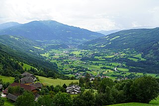
Upper Malta valley looking towards Kölnbrein Dam and Ankogel massif
The Maltatal (Slovene: Dolina reke Malte) is a valley in the High Tauern mountain range of the Central Eastern Alps. It follows the course of the Malta river down towards its confluence with the Lieser, itself a left tributary of the Drava. Most of the area belongs to the municipality of Malta in Carinthia, Austria.
The upper Maltatal ends at the Kölnbrein Dam east of the Ankogel Group, from where the Malta stream flows southeastwards about 38km (24mi) down along the mountains of the Reisseck Group to Gmünd and into the Lieser river. The valley is known for its many waterfalls during snowmelt season, therefore also called the 'Valley of Falling Waters'. An 18km (11mi) long scenic route, the former construction road of the Malta-Reisseck Power Plant Group with numerous serpentines and six tunnels leads up to the dam at 1,933m (6,342ft), site of a hotel and a hydropower exhibition.
The Kreuzeck Group is a mountain range of the Central Eastern Alps. It may be considered either a separate range or part of the larger High Tauern chain. Administratively, the range belongs to the Austrian states of Carinthia and, in the westernmost part, Tyrol.
The High Tauern are a mountain range on the main chain of the Central Eastern Alps, comprising the highest peaks east of the Brenner Pass. The crest forms the southern border of the Austrian states of Salzburg, Carinthia and East Tyrol, with a small part in the southwest belongs to the Italian province of South Tyrol. The range includes Austria's highest mountain, the Grossglockner at 3,798 metres (12,461 ft) above the Adriatic.
Malta is a municipality and a village in the district of Spittal an der Drau, in the Austrian state of Carinthia.
Bezirk Spittal an der Drau is an administrative district (Bezirk) in the state of Carinthia, Austria.
Lake Millstatt is a lake in Carinthia, Austria.
Fallbach Waterfall is a waterfall in the Maltatal valley of Austria in the Austrian Alps near Malta. It is particularly dramatic during snow-melt season. The waterfall is part of the Hohe Tauern National Park.
Reißeck is a municipality in the district of Spittal an der Drau in Carinthia, Austria.
Rennweg am Katschberg is a market town in the district of Spittal an der Drau in Carinthia, Austria.
Trebesing is a town in the district of Spittal an der Drau in the Austrian state of Carinthia.
Niederfalkenstein Castle is a medieval castle near Obervellach in Carinthia, Austria. It is part of the larger Falkenstein fortification complex; while the main fortress of Oberfalkenstein today is a ruin, the lower barbican of Niederfalkenstein is largely preserved.
The Kölnbrein Dam is an arch dam in the Hohe Tauern range within Carinthia, Austria. It was constructed between 1971 and 1979 and at 200 metres (660 ft) high, it is the tallest dam in Austria. The dam's reservoir serves as the primary storage in a three-stage pumped-storage power system that consists of nine dams, four hydroelectric power plants and a series of pipeline and penstocks. The complex is owned by Verbund power company and is referred to as the Malta-Reisseck Power Plant Group. The installed capacity of the group is 1,028.5 MW and its annual generation is 1,216 gigawatt-hours (4,380 TJ).
The Ankogel Group is a sub-group of the Central Eastern Alps. Together with the Goldberg Group, the Glockner Group, the Schober Group, the Kreuzeck Group, the Granatspitze Group, the Venediger Group, the Villgraten Mountains and the Rieserferner Group it forms the mountain range of the Hohe Tauern.
The Mölltaler Polinik, at 2,784 m (9,134 ft), is the highest mountain of the Kreuzeck group, a southern part of the High Tauern range in the Austrian state of Carinthia.
The Möll is a river in northwestern Carinthia in Austria, a left tributary of the Drava. Its drainage basin is 1,100.8 km2 (425.0 sq mi).
The Nock Mountains are the westernmost and highest mountain range of the Gurktal Alps in Austria, spread over parts of the federal states of Carinthia, Salzburg and Styria. Their appearance is characterised by numerous dome-like and grass-covered summits (Nocken). Their highest peak is the Eisenhut in Styria which reaches an elevation of 2,441 m (8,009 ft) AA.
Großer Hafner is a 3,076 m (10,092 ft) high partly-glaciated mountain of the Ankogel Group in the High Tauern range, located at the border between the Austrian states of Carinthia and Salzburg. It is the easternmost three-thousander peak of the range, and also in the entire Alps.
The Reißeck, also Großes Reißeck is, at 2,965 metres above the Adriatic (9,728 ft), the highest peak of the Reißeck Group in the High Tauern of Carinthia, Austria. The range forms the southern part of the larger Ankogel Group with its highest summit, the Hochalmspitze, separated by the col of Mallnitzer Scharte at 2,673 m (8,770 ft). The mountain also gives its name to the Reißeck municipality, located to the south in the Möll valley.
The Reisseck Group or Reißeck Group is a small mountain sub-range in the Austrian state of Carinthia. As the southern part of the Ankogel Group, it belongs to the High Tauern range of the Central Eastern Alps.
The Reisseck Railway is a mountain railway, that runs from Carinthia's Möll valley into the Reißeck Group, a small mountain range in southern Austria. It comprises the Reisseck Funicular and the Reisseck Mountain Railway.
The Isel is a 57.3 kilometres (35.6 mi) glacier-fed river in East Tyrol, Austria. The river flow varies with daily and seasonal temperature changes, and the riverbed is constantly shifting, creating a unique environment. The river's course runs along a geological fault running from NW to SE. It held a glacier during the last ice age, which has left boulders and gravel along the valley. There have been various proposals to dam and divert the water for use in generating hydroelectricity which have been opposed by environmentalists. Since 2015 the river has been designated a Natura 2000 site, which offers some protection. There is a hiking trail along the river, and it is known for excellent whitewater rafting conditions.
This page is based on this Wikipedia article Text is available under the CC BY-SA 4.0 license; additional terms may apply. Images, videos and audio are available under their respective licenses.