The High Tauern are a mountain range on the main chain of the Central Eastern Alps, comprising the highest peaks east of the Brenner Pass. The crest forms the southern border of the Austrian states of Salzburg, Carinthia and East Tyrol, with a small part in the southwest belongs to the Italian province of South Tyrol. The range includes Austria's highest mountain, the Grossglockner at 3,798 metres (12,461 ft) above the Adriatic.
Malta is a municipality and a village in the district of Spittal an der Drau, in the Austrian state of Carinthia.

Flattach is a municipality in Spittal an der Drau District in the Austrian state of Carinthia.

Mallnitz is a municipality in the Spittal an der Drau District in Carinthia, Austria.

Reißeck is a municipality in the district of Spittal an der Drau in Carinthia, Austria.

The Glockner Group is a sub-group of the Austrian Central Alps in the Eastern Alps, and is located in the centre section of the High Tauern on the main chain of the Alps.

The Venediger Group is a mountain range of the Central Eastern Alps. Together with the Granatspitze Group, the Glockner Group, the Goldberg Group, and the Ankogel Group, it forms the main ridge of the High Tauern. The highest peak is the Großvenediger at 3,657 m (AA), which gives its name to the group. Considerable parts of the Venediger Group belong to the core zone of the High Tauern National Park.
The Alpine Club Guides were the standard series of alpine climbing guidebookss that cover all the important mountain groups in the Eastern Alps. They were produced jointly by the German (DAV), Austrian (ÖAV) and South Tyrol Alpine Clubs (AVS). They had been published since 1950 by the firm of Bergverlag Rother in Munich, Germany.

The Dösener See is an alpine lake of Carinthia, Austria. It is part of the High Tauern National Park and located in the municipality of Mallnitz.

The Ankogel Group is a sub-group of the Central Eastern Alps. Together with the Goldberg Group, the Glockner Group, the Schober Group, the Kreuzeck Group, the Granatspitze Group, the Venediger Group, the Villgraten Mountains and the Rieserferner Group it forms the mountain range of the Hohe Tauern.

The Goldberg Group is a sub-group of the Hohe Tauern mountain range within the Central Eastern Alps. It is located in Austria, in the states of Salzburg and Carinthia. Its highest peak is the Hocharn, 3,254 m (AA). Other well known summits are the Hoher Sonnblick, with its observatory at 3,106 m above sea level (AA), and the Schareck at 3,123 m above sea level (AA)

The Villgraten Mountains or Deferegg Alps, also called the Defreggen Mountains are a subgroup of the Austrian Central Alps within the Eastern Alps of Europe. Together with the Ankogel Group, the Goldberg Group, the Glockner Group, the Schober Group, the Kreuzeck Group, the Granatspitze Group, the Venediger Group and the Rieserferner Group, the Villgraten Mountains are part of the major mountain range, the High Tauern. Their highest summit is the Weiße Spitze with a height of 2,962 m above sea level (AA).
The Rieserferner Group is a mountain range in the Austrian Central Alps. Together with the Ankogel Group, Goldberg Group, Glockner Group, Schober Group, Kreuzeck Group, Granatspitze Group, Venediger Group and the Villgraten Mountains the group is part of the High Tauern. The Rieserferner mountains extend across the Austrian state of Tyrol and the Italian province of South Tyrol. The mountains mainly lie in South Tyrol, where the greater part is protected within the Rieserferner-Ahrn Nature Park.

The Gailtal Alps, is a mountain range of the Southern Limestone Alps in Austria. It rises between the River Drava (Drau) and the Gail valley and through the southern part of East Tyrol. Its western group called "Lienz Dolomites", is sometimes counted as part of this range and sometimes seen as separate.

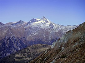
The Hochalmspitze is located east of Mallnitz in the Austrian state of Carinthia. It is sometimes called "Tauern Queen" as a counterpart to the "Tauern King", the Grossglockner.

Großer Hafner is a 3,076 m (10,092 ft) high partly-glaciated mountain of the Ankogel Group in the High Tauern range, located at the border between the Austrian states of Carinthia and Salzburg. It is the easternmost three-thousander peak of the range, and also in the entire Alps.

The Tauernkogel is a mountain, 2,988 m (AA), in the Venediger Group of Austria's High Tauern. It lies west of the Felber Tauern and the border between the states of Salzburg and Tyrol runs over the summit. It may be climbed on a difficult mountain tour via a steep snowfield in about 1.½ hours from the St. Pöltner Hut.

The Reißeck, also Großes Reißeck is, at 2,965 metres above the Adriatic (9,728 ft), the highest peak of the Reißeck Group in the High Tauern of Carinthia, Austria. The range forms the southern part of the larger Ankogel Group with its highest summit, the Hochalmspitze, separated by the col of Mallnitzer Scharte at 2,673 m (8,770 ft). The mountain also gives its name to the Reißeck municipality, located to the south in the Möll valley.

The Reisseck Group or Reißeck Group is a small mountain sub-range in the Austrian state of Carinthia. As the southern part of the Ankogel Group, it belongs to the High Tauern range of the Central Eastern Alps.

Pinnacle Peak is a remote 3,714-meter-elevation (12,184-foot) mountain summit of the Saint Elias Mountains, in Kluane National Park of Yukon, Canada. It ranks as the 37th-highest officially named mountain in Canada. It is situated at the head of the South Arm of the Kaskawulsh Glacier. Topographic relief is significant as the summit rises 1,500 meters (4,920 feet) above the Dusty Glacier in 3.5 kilometers. Neighbors include Mount Kennedy, 14 km to the south, and Mount Alverstone, 14 km to the south-southwest.