Malta, Austria

Last updated
Malta
Maltaberg Panorama, Hohe Tauern, Karnten.jpg
Austria adm location map.svg
Red pog.svg
Malta
Location within Austria
Coordinates: 46°58′N13°31′E / 46.967°N 13.517°E / 46.967; 13.517 Coordinates: 46°58′N13°31′E / 46.967°N 13.517°E / 46.967; 13.517
Country Austria
State Carinthia
District Spittal an der Drau
Government
   Mayor Klaus Rüscher
Area
[1]
  Total261.92 km2 (101.13 sq mi)
Elevation
843 m (2,766 ft)
Population
 (2018-01-01) [2]
  Total1,986
  Density7.6/km2 (20/sq mi)
Time zone UTC+1 (CET)
  Summer (DST) UTC+2 (CEST)
Postal code
9854
Area code 04733

Malta is a municipality and a village in the district of Spittal an der Drau, in the Austrian state of Carinthia.

Contents

Geography

The municipal area, with 262 square kilometres (101 sq mi) the second largest in Carinthia, covers most of the Maltatal valley, stretching from the Ankogel Group of the Hohe Tauern range in the northwest down to the town of Gmünd on the Lieser river, a tributary of the Drava. In the southwest it borders on the Reißeck municipality, while the Alpine crest including the Ankogel and Hochalmspitze peaks forms the northern border with the Austrian state of Salzburg. It includes the cadastral communities (Katastralgemeinden) of Dornbach, Malta proper, and Maltaberg.

Parish church Pfarrkirche Malta (Karnten)1.JPG
Parish church

Formerly an agricultural area, the local economy today largely depends on tourism with about 120,000 overnight stays per year. Attractions include a former provost's cottage (turned into an open-air museum) and the Fallbach Klettersteig, a via ferrata along the Fallbach Waterfal. In 1987 the Nationalpark Hohe Tauern was extended as far as the Ankogel Group and today, some 85.7 square kilometres of the municipal area are part of the national park territory.

History

Already settled in pre-Roman times, the first documented mention of Malta was between 957 and 992 under the name locus Malontina. In the 11th century, Ödenfest Castle was erected on the northern slopes of the Maltatal valley, then held by ministeriales of the Bishops of Brixen. It was devastated in the early 14th century, when the local Counts of Malta revolted against the Meinhardiner dukes of Carinthia.

A first church beneath the castle was mentioned between 1006 and 1039. The Gothic parish church of Maria Hilf Assumptio was built in various stages between the 13th and the 15th centuries. It has a Roman gravestone set into the wall, 15th-century paintings in the vaults, and 14th-century frescoes on the walls of the choir. In the neighbourhood is the Dornbach water castle (originally Gothic, but with alterations added in the 16th century); it is surrounded by a circuit of walls and a moat. The village of Fischertratten is centered on a Protestant church, erected upon the Patent of Toleration in 1787.

Kölnbrein Dam

Kolnbrein reservoir with Hochalmspitze and Ankogel peaks Kolnbreinspeicher von Weinschnabel.JPG
Kölnbrein reservoir with Hochalmspitze and Ankogel peaks

The Hochalm mountain road up the steep Malta valley leads to the Kölnbrein arch dam, part of the Malta hydroelectric plant run by the Verbund power company. Tunnels lead the water to the power stations in the Möll valley at Reißeck over 1100 m (3610 ft) below.

The dam collects a large amount of water from the surrounding mountains and also by a system of water supply tunnels bringing water from the Lieser and Möll rivers. The masonry dam built between 1971 and 1978 with a length of 626 m (2053 ft) reaches a height above ground of 200 m (656 ft) and therefore is the tallest in Austria. The reservoir extends 4.5 km (2.8 mi) behind the dam, holding approximately 200 million m³ of water.

Adjacent to the dam is a restaurant and a hotel. The reservoir serves competitive rowers for altitude training while the dam is a popular bungee jumping venue.

Politics

Municipal office Malta Gemeindeamt.JPG
Municipal office

Seats in the municipal assembly (Gemeinderat) as of 2015 local elections:

Notable people

Related Research Articles

High Tauern A mountain range of the eastern Alps

The High Tauern are a mountain range on the main chain of the Central Eastern Alps, comprising the highest peaks east of the Brenner Pass. The crest forms the southern border of the Austrian states of Salzburg, Carinthia and East Tyrol, with a small part in the southwest belongs to the Italian province of South Tyrol. The range includes Austria's highest mountain, the Grossglockner at 3,798 metres (12,461 ft) above the Adriatic.

Kaprun Place in Salzburg, Austria

Kaprun is a municipality in the Zell am See District in the state of Salzburg, Austria. The town is a tourist destination known as "Zell am See-Kaprun" with the neighbouring Zell am See and known for the glacier Kitzsteinhorn.

Gmünd, Carinthia Place in Carinthia, Austria

Gmünd in Kärnten is a municipality and historic town in the district of Spittal an der Drau, in the Austrian state of Carinthia.

Muhr Place in Salzburg, Austria

Muhr is a municipality of the Tamsweg District in the Austrian state of Salzburg.

Maltatal

The Maltatal is a valley in the High Tauern mountain range of the Central Eastern Alps. It follows the course of the Malta river down towards its confluence with the Lieser, itself a left tributary of the Drava. Most of the area belongs to the municipality of Malta in Carinthia, Austria.

Flattach Place in Carinthia, Austria

Flattach is a municipality in Spittal an der Drau District in the Austrian state of Carinthia.

Heiligenblut am Großglockner Place in Carinthia, Austria

Heiligenblut am Großglockner is a municipality in the district of Spittal an der Drau in Carinthia, Austria.

Lurnfeld Place in Carinthia, Austria

Lurnfeld is a market town in the district of Spittal an der Drau in the Austrian state of Carinthia. The municipality consists of the two Katastralgemeinden: Möllbrücke and Pusarnitz, comprising several small villages.

Mallnitz Place in Carinthia, Austria

Mallnitz is a municipality in the Spittal an der Drau District in Carinthia, Austria.

Mühldorf, Carinthia Place in Carinthia, Austria

Mühldorf is a municipality in the district of Spittal an der Drau in the Austrian state of Carinthia.

Obervellach Place in Carinthia, Austria

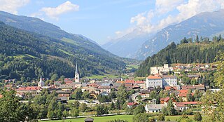
Obervellach is a market town in the district of Spittal an der Drau, in the Austrian state of Carinthia.

Reißeck Place in Carinthia, Austria

Reißeck is a municipality in the district of Spittal an der Drau in Carinthia, Austria.

Rennweg am Katschberg Place in Carinthia, Austria

Rennweg am Katschberg is a market town in the district of Spittal an der Drau in Carinthia, Austria.

Trebesing Place in Carinthia, Austria

Trebesing is a town in the district of Spittal an der Drau in the Austrian state of Carinthia.

Schwarzach im Pongau Place in Salzburg, Austria

Schwarzach im Pongau is a market town in the St. Johann im Pongau District in the Austrian state of Salzburg.

Kölnbrein Dam Dam in Malta, Carinthia,Austria

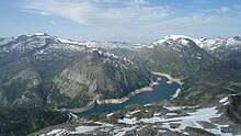
The Kölnbrein Dam is an arch dam in the Hohe Tauern range within Carinthia, Austria. It was constructed between 1971 and 1979 and at 200 metres (660 ft) high, it is the tallest dam in Austria. The dam's reservoir serves as the primary storage in a three-stage pumped-storage power system that consists of nine dams, four hydroelectric power plants and a series of pipeline and penstocks. The complex is owned by Verbund power company and is referred to as the Malta-Reisseck Power Plant Group. The installed capacity of the group is 1,028.5 MW and its annual generation is 1,216 gigawatt-hours (4,380 TJ).

Ankogel Group

The Ankogel Group is a sub-group of the Central Eastern Alps. Together with the Goldberg Group, the Glockner Group, the Schober Group, the Kreuzeck Group, the Granatspitze Group, the Venediger Group, the Villgraten Mountains and the Rieserferner Group it forms the mountain range of the Hohe Tauern.

Möll

The Möll is a river in northwestern Carinthia in Austria, a left tributary of the Drava.

Reißeck (mountain)

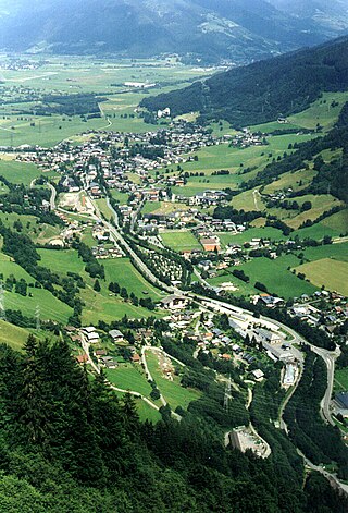
The Reißeck, also Großes Reißeck is, at 2,965 metres above the Adriatic (9,728 ft), the highest peak of the Reißeck Group in the High Tauern of Carinthia, Austria. The range forms the southern part of the larger Ankogel Group with its highest summit, the Hochalmspitze, separated by the col of Mallnitzer Scharte at 2,673 m (8,770 ft). The mountain also gives its name to the Reißeck municipality, located to the south in the Möll valley.

Reisseck Group Mountains in Austria

The Reisseck Group or Reißeck Group is a small mountain sub-range in the Austrian state of Carinthia. As the southern part of the Ankogel Group, it belongs to the High Tauern range of the Central Eastern Alps.

References

  1. "Dauersiedlungsraum der Gemeinden Politischen Bezirke und Bundesländer - Gebietsstand 1.1.2018". Statistics Austria. Retrieved 10 March 2019.
  2. "Einwohnerzahl 1.1.2018 nach Gemeinden mit Status, Gebietsstand 1.1.2018". Statistics Austria. Retrieved 9 March 2019.