Nock Mountains

Last updated
Nock Mountains
Nationalpark Nockberge Landschaft 26082007 01.jpg
Alpine landscape in Nock Mountains National Park
Highest point
Peak Eisenhut
Elevation 2,441 m above sea level (AA)
Dimensions
Length10 km (6.2 mi)
Geography
Alps location map.png
Red triangle with thick white border.svg
State Carinthia, Salzburg, Styria
Range coordinates 46°54′14″N13°43′40″E / 46.90389°N 13.72778°E / 46.90389; 13.72778
Parent range Gurktal Alps

The Nock Mountains [1] [2] [3] (German : Nockberge or Nockgebirge) are the westernmost and highest mountain range of the Gurktal Alps in Austria, spread over parts of the federal states of Carinthia, Salzburg and Styria. Their appearance is characterised by numerous dome-like and grass-covered summits (Nocken). Their highest peak is the Eisenhut in Styria which reaches an elevation of 2,441 m (8,009 ft) AA.

Contents

In July 2012 the Nock Mountains and the adjacent Lungau region were designated a biosphere reserve by UNESCO. They were largely unglaciated in the Ice Age and were a glacial refugium.

Geography

Lake Windeben on the Nockalm Road Nockalmstrasse Windebensee 26082007 61.jpg
Lake Windeben on the Nockalm Road

As westernmost part of the Gurktal Alps, the Nock Mountains are separated from the Low Tauern in the north, stretching as far as the Katschberg Pass (1,641  m (AA) ) in the west, by the Mur River. In the west, the rivers Lieser and Drau separate the Nock Mountains from the Ankogel Group of the High Tauern and from the Gailtal Alps. South of Lake Ossiach they are adjoined by the lower Sattnitz range and the Klagenfurt Basin, another part of the Gurktal Alps. To the east, within the Gurktal Alps they are bounded by a line from Gurk via Flattnitz Pass (1,400  m (AA) ) to the Paalbach stream.

The Nock Mountains may be divided into eight subgroups. South of Bad Kleinkirchheim are the stocks of the Mirnock massif (2,110  m (AA) ) with a significant topographic prominence of 1,343 m, the Wöllaner Nock (2,145  m (AA) ) and the Gerlitzen (1,909  m (AA) ) high above Lake Ossiach. The central region of the Nock Mountains is formed by the Millstätter Alpe (2,101  m (AA) ) and the Rosennock (2,440  m (AA) ), the highest summit in Carinthia. In the north are the stocks of the Schwarzwand (2,241  m (AA) ), the Königstuhl (2,406  m (AA) ) in Salzburg, which is also a tripoint, and the Eisenhut (2,441  m (AA) ).

The range has also been referred to in German language tourist brochures as the "Nocky Mountains", an allusion to the Rocky Mountains. [4]

National park

National park map Map at nationalpark nockberge location.png
National park map

The central area formed Nock Mountains National Park (German : Nationalpark Nockberge), established by the Carinthian state government on 1 January 1987. The remote area had already been developed with the construction of the scenic Nockalm Road from 1979. Further plans for a skiing region were averted by a citizens' initiative and a referendum in 1980, whereby 94% of the voters declared themselves against the project.

Despite its name, Nock Mountains National Park was designated a protected landscape (Category V) according to IUCN protected area categories. The territory of 184 square kilometres (71 sq mi) was entirely located within the Carinthian part of the range, along the border with Salzburg and Styria, stretching from Krems and the Lieser Valley in the west to Reichenau in the east, and down to Bad Kleinkirchheim and Radenthein in the south.

Related Research Articles

<span class="mw-page-title-main">Lake Ossiach</span> Lake in Carinthia, Austria

Lake Ossiach is a lake in the Austrian state of Carinthia. It is the state's third largest lake, superseded only by Lake Wörth and Lake Millstatt.

Bezirk Tamsweg is an administrative district (Bezirk) in the federal state of Salzburg, Austria. It is congruent with the Lungau region. The administrative centre of the district is Tamsweg.

Bezirk Spittal an der Drau is an administrative district (Bezirk) in the state of Carinthia, Austria.

<span class="mw-page-title-main">Noric Alps</span> Various mountain ranges of the Eastern Alps

The Noric Alps is a collective term denoting various mountain ranges of the Eastern Alps. The name derives from the ancient Noricum province of the Roman Empire on the territory of present-day Austria and the adjacent Bavarian and Slovenian area.

<span class="mw-page-title-main">Radstadt Tauern</span>

The Radstadt Tauern are a subrange of the Central Eastern Alps in Austria. Together with the Schladming Tauern, the Rottenmann and Wölz Tauern and the Seckau Tauern the Radstadt Tauern form the major range of mountains known as the Low Tauern. The mountains are found in the southeast of the Austrian state of Salzburg, between the upper reaches of the Enns and Mur rivers.

<span class="mw-page-title-main">Millstätter See</span> Glacial lake in Carinthia

Lake Millstatt is a lake in Carinthia, Austria.

<span class="mw-page-title-main">Katschberg Pass</span> Mountain pass in Austria at the border Carinthia / Salzburg

Katschberg Pass is a high mountain pass in the Central Eastern Alps in Austria between Rennweg am Katschberg in the state of Carinthia and Sankt Michael im Lungau in Salzburg.

<span class="mw-page-title-main">Bad Kleinkirchheim</span> Place in Carinthia, Austria

Bad Kleinkirchheim is a municipality and spa town in the district of Spittal an der Drau, in Carinthia, Austria.

<span class="mw-page-title-main">Krems, Carinthia</span> Place in Carinthia, Austria

Krems in Kärnten is a municipality in the district of Spittal an der Drau in Carinthia in Austria.

<span class="mw-page-title-main">Rennweg am Katschberg</span> Place in Carinthia, Austria

Rennweg am Katschberg is a market town in the district of Spittal an der Drau in Carinthia, Austria.

<span class="mw-page-title-main">Turracher See</span> Alpine lake in Carinthia, Styria

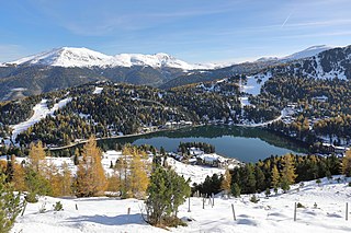
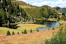
Lake Turrach is an Alpine lake at Turracher Höhe Pass, on the state border of Carinthia and Styria in Austria.

<span class="mw-page-title-main">Ankogel Group</span>

The Ankogel Group is a sub-group of the Central Eastern Alps. Together with the Goldberg Group, the Glockner Group, the Schober Group, the Kreuzeck Group, the Granatspitze Group, the Venediger Group, the Villgraten Mountains and the Rieserferner Group it forms the mountain range of the Hohe Tauern.

<span class="mw-page-title-main">Eisenhut (mountain)</span> Mountain in Austria

The Eisenhut is a mountain in the Central Eastern Alps located in Austria. At 2,441 metres (8,009 ft), it is the highest peak of the Gurktal Alps and the Carinthian-Styrian Alps.

<span class="mw-page-title-main">Gurktal Alps</span> Mountain range in the Central Eastern Alps in Austria

The Gurktal Alps is a mountain range in the Central Eastern Alps in Austria which is named after the valley of the Gurk river. The range stretches west to Lake Millstatt and east to Neumarkter Sattel. The highest peak is Eisenhut at 2,441m .

<span class="mw-page-title-main">Lavanttal Alps</span> Austrian section of the Alps

The Lavanttal Alps are part of the Central Eastern Alps in Austria and Slovenia, between the river Mur in the north and the Drava in the south.

<span class="mw-page-title-main">Tauern</span> German word which originally meant high mountain pass in the Austrian Central Alps

The word Tauern is German and originally meant 'high mountain pass' in the Austrian Central Alps, referring to the many bridleways and passes of the parallel side valleys of the River Salzach that cut into the mountain ranges. From the Middle Ages, when mining reached its heyday, the word Tauern was also used to name the corresponding ranges. The name has survived in many local placenames today.

<span class="mw-page-title-main">Großer Hafner</span>

Großer Hafner is a 3,076 m (10,092 ft) high partly-glaciated mountain of the Ankogel Group in the High Tauern range, located at the border between the Austrian states of Carinthia and Salzburg. It is the easternmost three-thousander peak of the range, and also in the entire Alps.

<span class="mw-page-title-main">Großer Rosennock</span> Mountain in the Gurktal Alps in Carinthia

The Großer Rosennock is, at 2,440 m AA (8,010 ft), the second highest of the Gurktal Alps in Carinthia, Austria, after the Eisenhut, which is just one meter higher.

<span class="mw-page-title-main">Reisseck Group</span> Mountains in Austria

The Reisseck Group or Reißeck Group is a small mountain sub-range in the Austrian state of Carinthia. As the southern part of the Ankogel Group, it belongs to the High Tauern range of the Central Eastern Alps.

Nockberge National Park was a 184 km2 / 23.3 km national park in Upper Carinthia, Nockberge in Austria. It was established in 1987 and dissolved in 2012. In July 2012, it was converted into Salzburger Lungau und Kärntner Nockberge, a UNESCO designated biosphere reserve.

References

  1. Lichtenberger, Elisabeth (2000). Austria, Austrian Academy of Science Press, pp. 138, 152 and 490. ISBN   978-3-7001-2775-8.
  2. Borntraeger, Gebrüder (1987). Monograph Series on Mineral Deposits, Issues 27-28, p. 220.
  3. Bedeker, K. (1970). Austria, Baedekers Autoführer-Verlag, p 140.
  4. For example: www.merian.de, www.nockalmstrasse.at Archived 2016-04-06 at the Wayback Machine , www.speick.de [ permanent dead link ], www.bz-berlin.de, www.wienerzeitung.at