Kreuzeck group

Last updated
Kreuzeck group
Bei den Vierzehn Seen.JPG
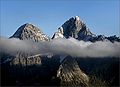
Fourteen Lakes and Mt. Hochkreuz, 2,709 m (8,888 ft)
Highest point
PeakMölltaler Polinik
Elevation 2,784 m (9,134 ft)
Coordinates 46°53′46″N13°09′24″E / 46.89611°N 13.15667°E / 46.89611; 13.15667 Coordinates: 46°53′46″N13°09′24″E / 46.89611°N 13.15667°E / 46.89611; 13.15667
Geography
Austria relief location map.jpg
Red triangle with thick white border.svg
Location within the Eastern Alps
CountryAustria
State Carinthia
Parent range Central Eastern Alps
Western Tauern Alps
High Tauern
Geology
Type of rock Gneiss, schist

The Kreuzeck Group is a mountain range of the Central Eastern Alps. It may be considered either a separate range or part of the larger High Tauern chain. Administratively, the range belongs to the Austrian states of Carinthia and, in the westernmost part, Tyrol (i.e. East Tyrol).

Contents

Geography

Kreuzeck summit Kreuzeck.jpg
Kreuzeck summit

The Kreuzeck Group is geographically separated from the main chain of the High Tauern in the north by the Möll, a left tributary of the Drava, up to the confluence within the Lurnfeld basin in the east. In the south, the Drava forms the border with the Gailtal Alps, part of the Southern Limestone Alps. The Iselsberg Pass near Lienz, connecting the Drava and Möll valleys, marks the western end.

The range is mainly composed of gneiss and garnet-mica-schists. The mountainous area (approximately 450 km²) is sparsely populated and used mainly for forestry and hunting. However, its tourism industry has improved in recent years. The area of the Reißeck municipality in the Möll valley is the site of the Reißeck-Kreuzeck hydroelectric power plant run by the Austrian Verbund company, whereby water is collected in several reservoirs in the Kreuzeck range.

Though named after Mt. Kreuzeck (2,701 m or 8,862 ft), the highest peaks of the range are the Mölltaler Polinik (2,784 m or 9,134 ft), Striedenkopf (2,749 m or 9,019 ft), and Hochkreuz (2,709 m or 8,888 ft).

Classification

According to the Alpine Club classification of the Eastern Alps, the Kreuzeck group (AVE 43) together with the Rieserferner group, the Villgraten Mountains (Defereggen) and the Schober group forms the southern front of the High Tauern ranges, a section of the Alpine divide.

According to the 2005 SOIUSA (International Standardized Mountain Subdivision of the Alps) proposal, the Kreuzeck group (II/A-17.IV.) is a subsection of the Western Tauern Alps. [1]

Related Research Articles

Central Eastern Alps Portion of the Eastern Alps mountain range through Austria and parts of surrounding countries

The Central Eastern Alps, also referred to as Austrian Central Alps or just Central Alps comprise the main chain of the Eastern Alps in Austria and the adjacent regions of Switzerland, Liechtenstein, Italy and Slovenia. Below it are the Southern Limestone Alps.

High Tauern A mountain range of the eastern Alps

The High Tauern are a mountain range on the main chain of the Central Eastern Alps, comprising the highest peaks east of the Brenner Pass. The crest forms the southern border of the Austrian states of Salzburg, Carinthia and East Tyrol, with a small part in the southwest belongs to the Italian province of South Tyrol. The range includes Austria's highest mountain, the Grossglockner at 3,798 metres (12,461 ft) above the Adriatic.

Noric Alps

The Noric Alps is a collective term denoting various mountain ranges of the Eastern Alps. The name derives from the ancient Noricum province of the Roman Empire on the territory of present-day Austria and the adjacent Bavarian and Slovenian area.

Eastern Alps Eastern part of the Alps mountain range

Eastern Alps is the name given to the eastern half of the Alps, usually defined as the area east of a line from Lake Constance and the Alpine Rhine valley up to the Splügen Pass at the Alpine divide and down the Liro River to Lake Como in the south. The peaks and mountain passes are lower than the Western Alps, while the range itself is broader and less arched.

Iselsberg Pass

The Iselsberg Pass, at 1,209 m (3,967 ft), is a high mountain pass in the Austrian Alps between the states of Tyrol and Carinthia. It separates the mountains of the Kreuzeck group in the south from the Schober group in the north, both parts of the Hohe Tauern range.

Flattach Place in Carinthia, Austria

Flattach is a municipality in Spittal an der Drau District in the Austrian state of Carinthia.

Reißeck Place in Carinthia, Austria

Reißeck is a municipality in the district of Spittal an der Drau in Carinthia, Austria.

Schober group

The Schober group is a sub-range of the Hohe Tauern mountains in the Central Eastern Alps, on the border between the Austrian states of Tyrol and Carinthia. Most of the range is located inside Hohe Tauern national park. It is named after Mt. Hochschober, 3,242 metres (10,636 ft), though its highest peak is Mt. Petzeck at 3,283 metres (10,771 ft).

Venediger Group

The Venediger Group is a mountain range of the Central Eastern Alps. Together with the Granatspitze Group, the Glockner Group, the Goldberg Group, and the Ankogel Group, it forms the main ridge of the High Tauern. The highest peak is the Großvenediger at 3,657 m (AA), which gives its name to the group. Considerable parts of the Venediger Group belong to the core zone of the High Tauern National Park.

SOIUSA

SOIUSA is a proposal for a new classification system of the Alps from the geographic and toponomastic point of view. It was designed by Sergio Marazzi, Italian researcher and author of the Orographic Atlas of the Alps SOIUSA. His book was presented with the patronage of the Italian Alpine Club on 23 Jan 2006, but has yet to receive any formal acceptance.

Ankogel Group

The Ankogel Group is a sub-group of the Central Eastern Alps. Together with the Goldberg Group, the Glockner Group, the Schober Group, the Kreuzeck Group, the Granatspitze Group, the Venediger Group, the Villgraten Mountains and the Rieserferner Group it forms the mountain range of the Hohe Tauern.

Western Tauern Alps

The Western Tauern Alps are a mountain range of the Central Eastern Alps.

Carnic and Gailtal Alps

The Carnic and Gailtal Alps is a geographic grouping of mountain ranges belonging to the Southern Limestone Alps. They are located in Austria and Italy.

Mölltaler Polinik

The Mölltaler Polinik, at 2,784 m (9,134 ft), is the highest mountain of the Kreuzeck group, a southern part of the High Tauern range in the Austrian state of Carinthia.

Möll

The Möll is a river in northwestern Carinthia in Austria, a left tributary of the Drava.

Goldberg Group

The Goldberg Group is a sub-group of the Hohe Tauern mountain range within the Central Eastern Alps. It is located in Austria, in the states of Salzburg and Carinthia. Its highest peak is the Hocharn, 3,254 m (AA). Other well known summits are the Hoher Sonnblick, with its observatory at 3,106 m above sea level (AA), and the Schareck at 3,123 m above sea level (AA)

Rieserferner Group

The Rieserferner Group is a mountain range in the Austrian Central Alps. Together with the Ankogel Group, Goldberg Group, Glockner Group, Schober Group, Kreuzeck Group, Granatspitze Group, Venediger Group and the Villgraten Mountains the group is part of the High Tauern. The Rieserferner mountains extend across the Austrian state of Tyrol and the Italian province of South Tyrol. The mountains mainly lie in South Tyrol, where the greater part is protected within the Rieserferner-Ahrn Nature Park.

Gailtal Alps

The Gailtal Alps, is a mountain range of the Southern Limestone Alps in Austria. It rises between the River Drava (Drau) and the Gail valley and through the southern part of East Tyrol. Its western group called "Lienz Dolomites", is sometimes counted as part of this range and sometimes seen as separate.

Reißeck (mountain)

The Reißeck, also Großes Reißeck is, at 2,965 metres above the Adriatic (9,728 ft), the highest peak of the Reißeck Group in the High Tauern of Carinthia, Austria. The range forms the southern part of the larger Ankogel Group with its highest summit, the Hochalmspitze, separated by the col of Mallnitzer Scharte at 2,673 m (8,770 ft). The mountain also gives its name to the Reißeck municipality, located to the south in the Möll valley.

Reisseck Group Mountains in Austria

The Reisseck Group or Reißeck Group is a small mountain sub-range in the Austrian state of Carinthia. As the southern part of the Ankogel Group, it belongs to the High Tauern range of the Central Eastern Alps.

References

  1. Marazzi, Sergio (2005). Atlante Orografico delle Alpi. SOIUSA (in Italian). Priuli & Verlucca. ISBN   978-88-8068-273-8.

Literature