Austria is a predominantly mountainous country in Central Europe, approximately between Germany, Italy and Hungary. It has a total area of 83,871 square kilometres (32,383 sq mi).

The Central Eastern Alps, also referred to as Austrian Central Alps or just Central Alps, comprise the main chain of the Eastern Alps in Austria and the adjacent regions of Switzerland, Liechtenstein, Italy and Slovenia. South of them is the Southern Limestone Alps.

Kapfenberg, with 22,182 inhabitants in 2023, is the third largest city in Styria, Austria, and lies in the valley of the Mürz near the town of Bruck an der Mur. The town's landmark is Burg Oberkapfenberg. Every year in June, the Ritterfest takes place at the castle, which is one of the largest events of its kind in Austria.

The Tux Alps or Tux Prealps are a sub-group of the Austrian Central Alps, which in turn form part of the Eastern Alps within Central Europe. They are located entirely within the Austrian federal state of Tyrol. The Tux Alps are one of three mountain ranges that form an Alpine backdrop to the city of Innsbruck. Their highest peak is the Lizumer Reckner, 2,886 m (AA), which rises between the glen of Wattentaler Lizum and the valley of the Navisbach. Their name is derived from the village of Tux which is tucked away in a side valley of the Zillertal.

The Noric Alps is a collective term denoting various mountain ranges of the Eastern Alps. The name derives from the ancient Noricum province of the Roman Empire on the territory of present-day Austria and the adjacent Bavarian and Slovenian area.

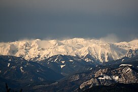
The Eastern Alps are usually defined as the area east of a line from Lake Constance and the Alpine Rhine valley, up to the Splügen Pass at the Alpine divide, and down the Liro River to Lake Como in the south. The peaks and mountain passes are lower than the Western Alps, while the range itself is broader and less arched.

The Radstadt Tauern are a subrange of the Central Eastern Alps in Austria. Together with the Schladming Tauern, the Rottenmann and Wölz Tauern and the Seckau Tauern the Radstadt Tauern form the major range of mountains known as the Low Tauern. The mountains are found in the southeast of the Austrian state of Salzburg, between the upper reaches of the Enns and Mur rivers.
Styrian Seeberg Pass is a high mountain pass in the Austrian Alps, located in the Bundesland of Styria, east of the Hochschwab Mountains. The pass forms the most important connection between the Mürz Valley at Kapfenberg and the pilgrimage destination of Mariazell. At the same time, it forms the division between the watersheds of the Mur and the Enns.
The Ennstal Alps, the Alps of the Enns valley, are a mountain range of the Northern Limestone Alps System. They are located primarily in the Austrian state of Styria, and also into the state of Upper Austria.

The Allgäu Alps are a mountain range in the Northern Limestone Alps, located on the Austria–Germany border, which covers parts of the German states of Bavaria and Baden-Württemberg and the Austrian states of Tyrol and Vorarlberg. The range lies directly east of Lake Constance.

The Leogang Mountains are a mountain range in Austria in the state of Salzburg and form part of the Northern Limestone Alps within the Eastern Alps. They are located between the Lofer valley, Saalfelden and Leogang and, together with the Lofer Mountains to the northwest, form two mountain massifs that are separated by the saddle of the Römersattel, but which the Alpine categorisation of the Eastern Alps defines as a single sub-group. The Leogang Mountains are separated from the Kitzbühel Alps to the south and the Steinernes Meer to the east by deeply incised valleys. Typical of the Steinberge are high plateaux with steep sides and sharply undulating high cirques.

The Rax-Schneeberg Group is a mountain range in the Northern Limestone Alps on the Styrian-Lower Austrian border in Austria.

Grüner See is a lake in Styria, Austria in a village named Tragöß, which is part of the municipality Tragöß-Sankt Katharein. The lake is surrounded by forests and three mountains: Pribitz, Meßnerin and Trenchtling (Hochturm), all part of the Hochschwab Mountains. The name "Green Lake" originated because of its emerald-green water. The clean and clear water comes from the snowmelt from the karst mountains and has a temperature of 6–7 °C (43–45 °F). During winter, the lake is only 1–2 m (3–7 ft) deep and the surrounding area is used as a county park.

The Mürzsteg Alps or Mürztal Alps are a mountain range in the Eastern Alps, which lie in the Austrian state of Styria, with a small part of the range in Lower Austria. The highest peak is the Hohe Veitsch in the centre of the group, while largest massif is the Schneealpe in the northwest, near the Rax.

The Schneealpe or Schneealm is a limestone massif in the Northern Limestone Alps on the Styrian-Lower Austrian border. Its highest point is the Windberg at 1,903 metres above sea level. Other peaks are the Ameisbühel, the Schönhaltereck and the Donnerwand.

The Lechquellen Mountains or Lechquellen range is a small mountain group within the Northern Limestone Alps of the Eastern Alps. It lies entirely within the Austrian state of Vorarlberg and includes the upper reaches of the river Lech with its headstreams in a horseshoe shape as well as the Upper Großwalsertal valley.

The Gailtal Alps, is a mountain range of the Southern Limestone Alps in Austria. It rises between the River Drava (Drau) and the Gail valley and through the southern part of East Tyrol. Its western group called "Lienz Dolomites", is sometimes counted as part of this range and sometimes seen as separate.

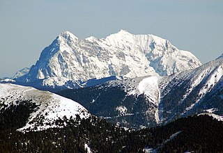
The Hochschwab in the Upper Styria is a mountain, 2,277 m (AA), and the highest summit in the eponymous mountain range.

The Fischbach Alps are part of the Prealps East of the Mur.

The Wechsel is a low mountain range in eastern Austria whose highest summit is the Hochwechsel. It also has two other summits over 1700 m. The massif forms the border between the states of Lower Austria and Styria for about 15 km, southeast of the Semmering and northeast of the Graz Basin, between the Feistritz Saddle and the eponymous pass of Wechsel.