
Edgar County is a county located in the U.S. state of Illinois. As of the 2020 United States Census, the population was 16,866. Its county seat is Paris.
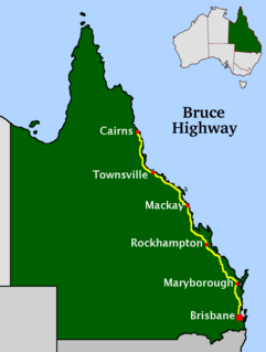
The Bruce Highway is a major highway in Queensland, Australia. Commencing in the state capital, Brisbane, it passes through areas close to the eastern coast on its way to Cairns in Far North Queensland. The route is part of the Australian National Highway and also part of Highway 1, the longest highway route in Australia. Its length is approximately 1,679 kilometres (1,043 mi); it is entirely sealed with bitumen. The highway is named after a popular former Queensland and federal politician, Harry Bruce. Bruce was the state Minister for Works in the mid-1930s when the highway was named after him. The highway once passed through Brisbane, but was truncated at Bald Hills when the Gateway Motorway became National Highway 1 upon its opening in December 1986.

Google LLC is an American multinational technology company that specializes in Internet-related services and products, which include online advertising technologies, a search engine, cloud computing, software, and hardware. It is considered one of the Big Five companies in the American information technology industry, along with Amazon, Apple, Meta (Facebook) and Microsoft.

Google Maps is a web mapping platform and consumer application offered by Google. It offers satellite imagery, aerial photography, street maps, 360° interactive panoramic views of streets, real-time traffic conditions, and route planning for traveling by foot, car, air and public transportation. As of 2020, Google Maps was being used by over 1 billion people every month around the world.

Google Earth is a computer program, formerly known as Keyhole EarthViewer, that renders a 3D representation of Earth based primarily on satellite imagery. The program maps the Earth by superimposing satellite images, aerial photography, and GIS data onto a 3D globe, allowing users to see cities and landscapes from various angles. Users can explore the globe by entering addresses and coordinates, or by using a keyboard or mouse. The program can also be downloaded on a smartphone or tablet, using a touch screen or stylus to navigate. Users may use the program to add their own data using Keyhole Markup Language and upload them through various sources, such as forums or blogs. Google Earth is able to show various kinds of images overlaid on the surface of the earth and is also a Web Map Service client. Recently Google has revealed that Google Earth now covers more than 98 percent of the world, and has captured 10 million miles of Street View imagery, a distance that could circle the globe more than 400 times.

OpenStreetMap (OSM) is a collaborative project to create a free editable geographic database of the world. The geodata underlying the maps is considered the primary output of the project. The creation and growth of OSM has been motivated by restrictions on use or availability of map data across much of the world, and the advent of inexpensive portable satellite navigation devices.
Highway 27 is a provincial highway in the Canadian province of Saskatchewan. Being 34 kilometres (21 mi) long, it runs from Highway 41 at Aberdeen to Highway 2 east of Prud'homme.

Panoramio was a geo-located tagging, photo sharing mashup active between 2005 and 2016. Photos uploaded to the site were accessible as a layer in Google Earth and Google Maps. The site's goal was to allow Google Earth users to learn more about a given area by viewing the photos that other users had taken at that location. Panoramio was acquired by Google in 2007. In 2009 the website was among 1000 most popular websites worldwide.

Google Street View is a technology featured in Google Maps and Google Earth that provides interactive panoramas from positions along many streets in the world. It was launched in 2007 in several cities in the United States, and has since expanded to include cities and rural areas worldwide. Streets with Street View imagery available are shown as blue lines on Google Maps.
The Kampala Northern Bypass Highway, often referred to as the Northern Bypass, is a road in Uganda. It forms a semicircle across the northern suburbs of Kampala, Uganda's capital and largest city. The road was constructed to relieve traffic congestion within the city center, allowing cross-country traffic to bypass the city's downtown area.

Pichai Sundararajan, better known as Sundar Pichai, is an Indian-American business executive. He is the chief executive officer (CEO) of Alphabet Inc. and its subsidiary Google.
Waze is a subsidiary of Google that provides satellite navigation software. It works on smartphones and other computers that have GPS support. It provides turn-by-turn navigation information and user-submitted travel times and route details, while downloading location-dependent information over a mobile telephone network. Waze describes its app as a community-driven GPS navigation app, which is free to download and use.
Several special routes of U.S. Route 74 exist. In order from west to east they are as follows.
Google Street View was first introduced in the United States on May 25, 2007, and until November 26, 2008, featured camera icon markers, each representing at least one major city or area, and usually the other nearby cities, towns, suburbs, and parks. Many areas that had coverage were represented by icons.
Jeffrey Adgate "Jeff" Dean is an American computer scientist and software engineer. He is currently the lead of Google AI, Google's AI division.

Busta Rhymes Island is a proposed name for an otherwise unnamed island in Shrewsbury, Worcester County, Massachusetts. The name refers to the rapper Busta Rhymes. The island is located in Mill Pond in Shrewsbury and measures 40 by 40 feet. The island was named in 2005 by Shrewsbury resident Kevin O'Brien who began frequenting and caring for the upkeep of the island. O'Brien stated he wanted it to be called Busta Rhymes Island as it had "rope-swinging, blueberries, and. .. stuff Busta would enjoy."
