Seebensee | |
---|---|
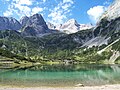
![]() The Seebensee from the climb to the Ehrwalder Sonnenspitze | |
Location | Mieming Range (Tyrol, Austria) |
Coordinates | 47°22′06″N10°56′03″E / 47.36833°N 10.93417°E Coordinates: 47°22′06″N10°56′03″E / 47.36833°N 10.93417°E |
Primary outflows | Geißbach → Loisach |
Max. length | 0.400 kilometres (0.249 mi) |
Max. width | 0.200 kilometres (0.124 mi) |
Max. depth | c. 30 metres (98 ft) |
Surface elevation | 1,657 metres (5,436 ft) |
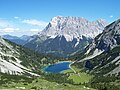
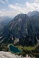
The Seebensee is a natural high mountain lake (an ice-age affected, rock basin lake [1] ) at a height of 1,657 metres, south of Ehrwald in the Mieming Range. It is surrounded by the Vorderer Tajakopf in the east, the Vorderer Drachenkopf in the south and the Ehrwalder Sonnenspitze in the west.
The Seebensee has no significant above-ground inflows and one outflow via the Seebenbach Falls and the Geißbach into the Loisach river. The lake may be reached from Ehrwald on a forest track via the Ehrwalder Alm, via the Seeben Klettersteig, a difficult klettersteig, or via one of the two protected mountain trails Hoher Gang or Immensteig . From Biberwier, the lake may be reached via the arête of the Biberwierer Scharte, and from Leutasch through the Gaistal valley.
Near the lake (to the northeast) lies the managed alpine pasture of Seebenalm. To the south on a rock terrace above the lake is the Coburger Hut owned by the German Alpine Club.
The surface of the lake covers around 6.5 hectares, but it used to be larger. As a result of soil and vegetation analyses it has been deduced that there was a large area southeast of the lake which used to be part of it (today easily visible, especially from above, as a mainly grassy plain) but which has now silted up. [2]
The Zugspitze, at 2,962 m (9,718 ft) above sea level, is the highest peak of the Wetterstein Mountains as well as the highest mountain in Germany. It lies south of the town of Garmisch-Partenkirchen, and the Austria–Germany border runs over its western summit. South of the mountain is the Zugspitzplatt, a high karst plateau with numerous caves. On the flanks of the Zugspitze are three glaciers, including the two largest in Germany: the Northern Schneeferner with an area of 30.7 hectares and the Höllentalferner with an area of 24.7 hectares. The third is the Southern Schneeferner which covers 8.4 hectares.
Bavarian Alps is a summarizing term of several mountain ranges of the Northern Limestone Alps in the German state of Bavaria.
Leutasch is a municipality in the northern part of the district Innsbruck-Land in the Austrian state of Tyrol about 30 km northwest of Innsbruck and 10 km northwest of Seefeld in Tirol
The Wetterstein mountains, colloquially called Wetterstein, is a mountain group in the Northern Limestone Alps within the Eastern Alps. It is a comparatively compact range located between Garmisch-Partenkirchen, Mittenwald, Seefeld in Tirol and Ehrwald along the border between Germany (Bavaria) and Austria (Tyrol). Zugspitze, the highest peak is at the same time the highest mountain in Germany.
The Ammergau Alps are a mountain range in the Northern Limestone Alps in the states of Bavaria (Germany) and Tyrol (Austria). They cover an area of about 30 x 30 km and begin at the outer edge of the Alps. The highest summit is the Daniel which has a height of 2,340 metres (7,680 ft).
The Dachstein Mountains are a mountain range in the Northern Limestone Alps.
Außerfern refers to the district of Reutte in the Austrian federal state of Tyrol.
The Mieming(er) Range, Mieminger Chain or Mieminger Mountains, is a mountain range of the Northern Limestone Alps in the Eastern Alps. It is located entirely in Austria within the state of Tyrol. This sub-group is somewhat in the shadows of its more famous neighbour, the Wetterstein to the north. Whilst the region around the Coburger Hut and the lakes of Seebensee and Drachensee in the west and the Hohe Munde in the extreme east receive large numbers of visitors, the less developed central area remains very quiet. The Hohe Munde is also a popular and challenging ski touring destination.
The Werdenfelser Land is a region of Upper Bavaria that extends from Mittenwald in the south to Farchant. It includes parts of the Bavarian Alps. From the Middle Ages until the Thirty Years' War, the Werdenfelser Land was subject to the Prince-Bishop of Freising, not the Duke of Bavaria.
The Knorr Hut is a mountain hut belonging to the German Alpine Club and located in the Wetterstein Mountains at a height of 2,052 m. Its lies right on the edge of the Zugspitzplatt where it drops into the Reintalanger in a location with scenic views and is an important base for hikers who can climb up to it on the normal route from the town of Garmisch-Partenkirchen through the Reintal valley to Germany's highest mountain, the Zugspitze.
The Höllentalanger Hut is a managed hut owned by the German Alpine Club in the Wetterstein Mountains of Bavaria, in the district of Garmisch-Partenkirchen. The hut lies in a narrow defile between the Höllental-Blassen and Waxenstein-Riffelwand crest and is open from the end of May to mid-October. It has more than 80 bedspaces.
The Lechquellen Mountains or Lechquellen range is a small mountain group within the Northern Limestone Alps of the Eastern Alps. It lies entirely within the Austrian state of Vorarlberg and includes the upper reaches of the river Lech with its headstreams in a horseshoe shape as well as the Upper Großwalsertal valley.
The Hochplattig is a mountain, 2,768 m (AA) high, and the highest summit in the Mieming Chain, a mountain range in the Northern Limestone Alps in the Austrian state of Tyrol.
The Daniel is a mountain in the Austrian state of Tyrol, and the highest peak in the Ammergau Alps, a range within the Northern Limestone Alps . Located near the villages of Ehrwald and Lermoos, it is a popular mountain with hikers. Its North Face is around 200 metres high and its South Face has a more schrofen-like character. With the almost equally high Upsspitze (2,332 m) it forms a double summit. To the northwest is a neighbouring peak, the Hochschrutte (2,247 m).
A mountain sport or Alpine sport is one of several types of sport that take place in hilly or mountainous terrain.
At 2,163 metres, the Gehrenspitze is the third highest mountain in the Tannheim Group and is situated in the Austrian state of Tyrol. It should not be confused with the Gehrenspitze in the Wetterstein Mountains.
The Vorderer Tajakopf is a 2,450-metre-high mountain in the Mieming Chain in the Austrian state of Tyrol.
The Sonnenspitze, also Ehrwalder Sonnenspitze, is a mountain, 2,417 m (AA) high, in the Mieming Chain in the Austrian state of Tyrol with a subpeak, the Signalgipfel (2,412 m) to the south. An ascent of the Sonnenspitze is one of the most popular tours of the Mieming Chain.
The Coburger Hut is an Alpine hut owned by the Coburg Branch of the German Alpine Club. It is located in the Mieming Range in the Austrian state of Tyrol and lies only a few metres in height above the lake of Drachensee. The accommodation is generally open from June to early October and there is a winter room.
The Hinterer Tajakopf is a mountain, 2,408 metres high, in the Mieming Range in the Austrian state of Tyrol.