Vorderer Tajakopf

Last updated
Vorderer Tajakopf
20070624-Vorderer Tajakopf MQ.jpg
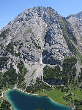
The Vorderer Tajakopf above the Seebensee (view from the west)
Highest point
Elevation 2,450  m (AA) (8,040 ft)
Prominence 191 m Hinteres Tajatörl
Isolation 1.5 km  Östliche Griesspitzen
Coordinates 47°21′50″N10°56′51″E / 47.36399°N 10.94738°E / 47.36399; 10.94738 Coordinates: 47°21′50″N10°56′51″E / 47.36399°N 10.94738°E / 47.36399; 10.94738
Geography
Austria relief location map.jpg
Red triangle with thick white border.svg
Vorderer Tajakopf
Parent range Mieming Chain
Geology
Type of rock Wetterstein Limestone
Climbing
First ascent O. v. Unterrichter, J. Gampl, G. Beyrer on 16 August 1894
Normal route via the Vordere Tajatörl, UIAA I

The Vorderer Tajakopf is a 2,450-metre-high mountain in the Mieming Chain in the Austrian state of Tyrol.

Austria Federal republic in Central Europe

Austria, officially the Republic of Austria, is a country in Central Europe comprising nine federated states. Its capital, largest city and one of nine states is Vienna. Austria has an area of 83,879 km2 (32,386 sq mi), a population of nearly nine million people and a nominal GDP of $477 billion. It is bordered by the Czech Republic and Germany to the north, Hungary and Slovakia to the east, Slovenia and Italy to the south, and Switzerland and Liechtenstein to the west. The terrain is landlocked and highly mountainous, lying within the Alps; only 32% of the country is below 500 m (1,640 ft), and its highest point is 3,798 m (12,461 ft). The majority of the population speaks local Bavarian dialects as their native language, and German in its standard form is the country's official language. Other regional languages are Hungarian, Burgenland Croatian, and Slovene.

Tyrol (state) State in Austria

Tyrol is a federal state (Bundesland) in western Austria. It comprises the Austrian part of the historical Princely County of Tyrol. It is a constituent part of the present-day Euroregion Tyrol–South Tyrol–Trentino. The capital of Tyrol is Innsbruck.

The normal route to the summit runs from the Coburger Hut (1,917 m) over the Vorderes Tajatörl and the south arête. More recently the Vorderer Tajakopf has been climbed more frequently up a challenging klettersteig laid out in 2000 along the west arête. The neighbouring Hinterer Tajakopf (2,408 m) is accessible via the Vorderer Tajatörl on the Coburger Klettersteig or from the Hinterer Tajatörl.

Normal route

A normal route or normal way is the most frequently used route for ascending and descending a mountain peak. It is usually the simplest route.

Coburger Hut mountain hut

The Coburger Hut is an Alpine hut owned by the Coburg Branch of the German Alpine Club. It is located in the Mieming Range in the Austrian state of Tyrol and lies only a few metres in height above the lake of Drachensee. The accommodation is generally open from June to early October and there is a winter room.

Arête A narrow ridge of rock which separates two valleys

An arête is a narrow ridge of rock which separates two valleys. It is typically formed when two glaciers erode parallel U-shaped valleys. Arêtes can also form when two glacial cirques erode headwards towards one another, although frequently this results in a saddle-shaped pass, called a col. The edge is then sharpened by freeze-thaw weathering, and the slope on either side of the arete steepened through mass wasting events and the erosion of exposed, unstable rock. The word ‘arête’ is actually French for edge or ridge; similar features in the Alps are described with the German equivalent term Grat.

Literature

The Alpine Club Guides are the standard series of Alpine guides that cover all the important mountain groups in the Eastern Alps. They are produced jointly by the German (DAV), Austrian (ÖAV) and South Tyrol Alpine Clubs (AVS). They have been published since 1950 by the firm of Bergverlag Rother in Munich, Germany.

International Standard Book Number Unique numeric book identifier

The International Standard Book Number (ISBN) is a numeric commercial book identifier which is intended to be unique. Publishers purchase ISBNs from an affiliate of the International ISBN Agency.

Related Research Articles

Rhonestock mountain

The Rhonestock is a mountain of the Uri Alps, located on the border between the Swiss cantons of Valais and Uri and belongs to the Winterberg massif. It lies south of the Dammastock, between the Rhone Glacier and the Damma Glacier.

Ellmauer Halt mountain

The Ellmauer Halt (2,344 m) is the highest peak in the mountain massif of the Wilder Kaiser in the Kaiser range in the Austrian state of Tyrol. To the east is the summit of the Kapuzenturm, a striking and isolated rock pinnacle. In 1883 the first summit cross was erected on the mountain top.

Pyramidenspitze mountain

The Pyramidenspitze is a mountain, 1,998 metres high, of the Kaisergebirge in the Austrian state of Tyrol.

Alpspitze mountain in Bavaria, Germany

The Alpspitze is a mountain, 2,628 m, in Bavaria, Germany. Its pyramidal peak is the symbol of Garmisch-Partenkirchen and is one of the best known and most attractive mountains of the Northern Limestone Alps. It is made predominantly of Wetterstein limestone from the Upper Triassic.

First Schafalpenkopf mountain

The First Schafalpenkopf or Southwestern Schafalpenkopf is a 2,272-metre-high mountain in the Allgäu Alps. It is part of the Schafalpenköpfe and the Mindelheim Klettersteig.

Langbathseen lakes in Upper Austria, Austria

The Langbathseen are two mountain lakes in Upper Austria's part of the Salzkammergut, 8 kilometers (5.0 mi) from Ebensee. Its excellent visibility makes the Vorderer Langbathsee a popular diving site.

Seebensee lake in Austria

The Seebensee is a natural high mountain lake at a height of 1,657 metres, south of Ehrwald in the Mieming Range. It is surrounded by the Vorderer Tajakopf in the east, the Vorderer Drachenkopf in the south and the Ehrwalder Sonnenspitze in the west.

Goinger Halt mountain in the Kaisergebirge range in the Northern Limestone Alps in Austria

The Goinger Halt is a mountain in the Kaisergebirge range in the Northern Limestone Alps in Austria. It has a double summit: a northern top to the rear, the Hinterer Goinger Halt, and a higher, southern top in front, the Vorderer Goinger Halt. The name "Halt" means something like Alpine meadow and refers therefore to the peak over the meadow areas, that belong to the parish of Going.

Karlspitzen mountain

The Karlspitzen is a twin-peaked mountain in the middle of the Kaisergebirge range of the Northern Limestone Alps in Austria. The two peaks are the northern Hinteren Karlspitze and the southern Vorderen Karlspitze with its summit cross; they are linked by a sharp, exposed, rocky arête. Seen from the south the Vordere Karlspitze is a huge and very prominent block of rock, whereas the Hintere Karlspitze is hidden behind other (lower) neighbouring mountains.

Mieming Range mountain range

The Mieming(er) Range, Mieminger Chain or Mieminger Mountains, is a mountain range of the Northern Limestone Alps in the Eastern Alps. It is located entirely in Austria within the state of Tyrol. This sub-group is somewhat in the shadows of its more famous neighbour, the Wetterstein to the north. Whilst the region around the Coburger Hut and the lakes of Seebensee and Drachensee in the west and the Hohe Munde in the extreme east receive large numbers of visitors, the less developed central area remains very quiet. The Hohe Munde is also a popular and challenging ski touring destination.

Schrammsteine mountain

The Schrammsteine are a long, strung-out, very jagged group of rocks in the Elbe Sandstone Mountains located east of Bad Schandau in Saxon Switzerland in East Germany. To the north they are bordered by the Kirnitzsch valley, to the south by the Elbe valley and to the east by the Affensteine rocks. The high point of the chain lies at over 400 m above sea level (HN). The viewing point on the Schrammsteine lies at a height of 417.2 m above HN.

Hinterer Bratschenkopf mountain

The Hinterer Bratschenkopf is a mountain in the Glockner Group on the Fusch-Kaprun ridge in the High Tauern, a high mountain range in the Austrian Central Alps. According to the listed sources it is 3,412 metres high, but the Austrian Federal Office for Metrology and Survey gives its height as 3,413 metres. The mountain lies in the Austrian state of Salzburg. It appears from the north, east and south as a gently curved firn summit, but from the west it has a mighty, 1,400-metre-high (4,600 ft) and 40 to 60° rock face. A steep, 500-metre-long (1,600 ft) knife-edge ridge bears away from the mountaintop to the north. Due to its close proximity to the Heinrich Schwaiger Haus, the summit is a popular viewing point. The peak was first climbed on 18 September 1869 by the Munich Alpinist, Karl Hofmann, the Prague businessman, Johann Stüdl, and mountain guides Thomas Groder and Josef Schnell from Kals am Großglockner.

Eggstock (Schwyzer Alps) mountain in Switzerland

The Eggstock is a mountain massif of the Schwyzer Alps, located on the border between the Swiss canton of Schwyz and canton of Glarus, north of Braunwald. It lies on the range east of the Bös Fulen, between the valley of Bösbächi and the cirque of Braunwald and is composed of three summits: the Hinterer Eggstock, the Mittlerer Eggstock and the Vorderer Eggstock.

Erlspitze mountain

The Erlspitze, at 2,405 m (AA), is the highest mountain of the range to which it gives its name in the southeastern corner of the Karwendel Alps. Its pyramid-shaped summit makes it a good observation peak north of the Erl Saddle and the Solsteinhaus mountain hut.

Hochschober mountain

The Hochschober is the mountain that gives its name to the Schober Group in the High Tauern, although the summit is only the fourth highest in the group. This may have arisen because the north face of the mountain is an impressive sight from Kals.

Großer Bärenkopf mountain

The Große Bärenkopf or Weißer Bärenkopf is a twin-topped mountain in the Glockner Group in the Fuscher/Kapruner Kamm of the High Tauern, a range in the Austrian Central Alps. The mountain lies exactly on the border between the states of Salzburg and Carinthia.

Glödis mountain

The Glödis is one of the most regularly formed summits in the Schober Group in East Tyrol, hence its sobriquet, the "Matterhorn of the Schober Group". It is an impressive sight both from the Debanttal valley and the valley of Kalser Lesachtal.

Pirchkogel mountain in Austria

The Pirchkogel is a mountain, 2,828 m, in the Stubai Alps in Tyrol. It is a good viewing mountain.

Hinterer Tajakopf mountain

The Hinterer Tajakopf is a mountain, 2,408 metres high, in the Mieming Range in the Austrian state of Tyrol.