
Vorarlberg is the westernmost state (Land) of Austria. It has the second-smallest geographical area after Vienna and, although it has the second-smallest population, it also has the second-highest population density. It borders on three countries: Germany, Switzerland, and Liechtenstein. The only Austrian state that shares a border with Vorarlberg is Tyrol, to the east.

Bludenz is a town in the westernmost Austrian state of Vorarlberg. It is the administrative seat of the Bludenz District, which encompasses about half of the Vorarlberg's territory.

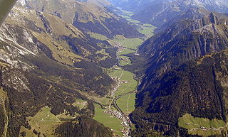
Montafon is a 39 km long valley in the westernmost Austrian federal state of Vorarlberg.

Sankt Anton am Arlberg, commonly referred to as St. Anton, is a village and ski resort in the Austrian state of Tyrol. It lies in the Tyrolean Alps, with aerial tramways and chairlifts up to 2,811 m (9,222 ft), yielding a vertical drop of 1,507 m (4,944 ft). It is also a popular summer resort among hikers, trekkers and mountaineers.

Landeck is a city in the Austrian state of Tyrol, the capital of the district of Landeck.

Arlberg is a massif between Vorarlberg and Tyrol in Austria. The highest peak is the Valluga at 2,811 metres (9,222 ft). The name Arlberg derives from the tradition of the "Arlenburg", who are said to have once established themselves on the Tyrolean side of the Arlberg passes. Another story derives the name from the "Arlenbushes" that are very numerous there. Ski resorts at the Arlberg include Lech, Zürs, Stuben, St. Christoph, St. Anton, Oberlech, Stubenbach, Zug, Warth

Lech am Arlberg is a mountain village and an exclusive ski resort in the Bludenz district in the westernmost Austrian state of Vorarlberg, on the banks of the river Lech.
The Bezirk Landeck is an administrative district (Bezirk) in Tyrol, Austria. It borders the district Reutte in the north, the district Imst in the east, South Tyrol (Italy) and Graubünden (Switzerland) in the south, and the district Bludenz (Vorarlberg) in the west.
The Bezirk Bludenz is an administrative district (Bezirk) in Vorarlberg, Austria.

Eastern Alps is the name given to the eastern half of the Alps, usually defined as the area east of a line from Lake Constance and the Alpine Rhine valley up to the Splügen Pass at the Alpine divide and down the Liro River to Lake Como in the south. The peaks and mountain passes are lower than the Western Alps, while the range itself is broader and less arched.

Flexen Pass is a high mountain pass in the Austrian Alps in the Bundesland of Vorarlberg. It is at an elevation of 1,773 metres (5,817 ft).
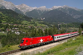
The Arlberg Railway, which connects the Austrian cities Innsbruck and Bludenz, is Austria's only east-west mountain railway. It is one of the highest standard gauge railways in Europe and the second highest in Austria, after the Brenner. The 135.7 km line is a highly problematic mountain railway, in part because it is threatened by avalanches, mudslides, rockfalls and floods. It is operated by the Austrian Federal Railways (ÖBB) and frequented by international trains, including the Orient Express.

Klösterle is a municipality in the district of Bludenz in the Austrian state of Vorarlberg.

Landeck-Zams railway station is a railway station on the Arlberg railway between Innsbruck and Bludenz in Tyrol, Austria. It is frequented by more than 2000 travellers a day, whereby a majority of them are commuters that are working or studying in Innsbruck.
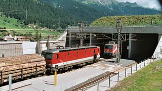
St. Anton am Arlberg is a railway station on the Arlberg railway between Innsbruck and Bludenz in Tyrol, Austria. It is located directly between the 10.648 km (6.616 mi) long Arlbergtunnel and the Wolfsgrubentunnel.
The Lechtal is an alpine valley in Austria, the greater part of which belongs to the state of Tyrol and the smaller part to Vorarlberg. The Lech river flows through the valley.

The Vorarlberg Railway denotes a through line running through the Austrian state of Vorarlberg. Its route is similar to the Rheintal/Walgau Autobahn from the border between Lindau and Hörbranz to Bludenz, where it connects to the Arlberg Railway. The entire route is owned and operated by the Austrian Federal Railways.

The Lechquellen Mountains or Lechquellen range is a small mountain group within the Northern Limestone Alps of the Eastern Alps. It lies entirely within the Austrian state of Vorarlberg and includes the upper reaches of the river Lech with its headstreams in a horseshoe shape as well as the Upper Großwalsertal valley.

The Arlberg Schnellstraße (S16) is an expressway (Schnellstraße) in Austria that is part of the E 60. It runs along a length of 62.2 km between Zams and Bludenz and connects the Inn Valley Autobahn (A12) in Tyrol with the Rheintal/Walgau Autobahn (A14) in Vorarlberg. The border between the two states is located in the Arlberg Tunnel (toll), which is 13,972 m long and is also the longest road tunnel in Austria. Overall, more than half of the route runs in long tunnels.
Stuben am Arlberg is a winter sports resort in the town of Klösterle in the westernmost Austrian province of Vorarlberg. It is located at an altitude of 1,410 meters and had 90 inhabitants.
