Au | |
---|---|
Coordinates: 47°19′00″N09°59′00″E / 47.31667°N 9.98333°E Coordinates: 47°19′00″N09°59′00″E / 47.31667°N 9.98333°E | |
Country | Austria |
State | Vorarlberg |
District | Bregenz |
Government | |
• Mayor | Ing. Andreas Simma (Auer Liste) |
Area | |
• Total | 44.91 km2 (17.34 sq mi) |
Elevation | 800 m (2,600 ft) |
Population (2018-01-01) [2] | |
• Total | 1,736 |
• Density | 39/km2 (100/sq mi) |
Time zone | UTC+1 (CET) |
• Summer (DST) | UTC+2 (CEST) |
Postal code | 6883 |
Area code | 05515 |
Vehicle registration | B |
Website | www.au-schoppernau.at |
Au is a town in the Bregenz Forest in Vorarlberg (Austria).
The town belongs to the Bregenz Forest, is part of the district of Bregenz, and lies in the Upper Bregenz Forst.
40 percent of its 45 km² area is covered with forest, 34.4% of the area is used as alpine pasture (Almwirtschaft) and for other forms of alpine agriculture.
The town itself is unlike most others in the area, as it has no real center. Au is an example of a "scattered village" (German: Streudorf). It consists of several districts: Am Stein, Argenau, Argenstein, Argenzipfel, Jaghausen, Kreuzgasse, Lebernau, Lugen, Lisse, Rehmen, Schrecken, and Wieden.
The town hall is located in Argenau, but the parish church is located in Jaghausen. The district of Rehmen also has its own church.
The river Bregenzer Ach, the largest river in the region, flows through Au and divides it into two parts: The one part is called Schattseite (meaning “shady side”), and consists of the districts of Argenau, Argenzipfel and Wieden; the other part is called Sonnseite (meaning “sunny side”) and consists (mainly) of Rehmen and Schrecken. Alongside the river runs the L200 road, which is the main route through the Bregenz Forest.
From 1805 to 1814, Au belonged to the Kingdom of Bavaria, but was then returned to Austria. Au has belonged to the province of Vorarlberg since the latter’s foundation in 1861.
After World War II, Au was included within the French Occupation Zone of Austria. The occupation lasted from 1945 until the Austrian State Treaty was signed in 1955. The occupation force also included many Moroccan soldiers serving in the French army.
Year | Pop. | ±% |
---|---|---|
1869 | 1,039 | — |
1880 | 1,060 | +2.0% |
1890 | 1,067 | +0.7% |
1900 | 1,116 | +4.6% |
1910 | 1,210 | +8.4% |
1923 | 1,080 | −10.7% |
1934 | 1,269 | +17.5% |
1939 | 1,263 | −0.5% |
1951 | 1,414 | +12.0% |
1961 | 1,440 | +1.8% |
1971 | 1,476 | +2.5% |
1981 | 1,466 | −0.7% |
1991 | 1,572 | +7.2% |
2001 | 1,643 | +4.5% |
2011 | 1,692 | +3.0% |
2017 | 1,728 | +2.1% |
The town council of Au, called Gemeinderat, consists of 18 members, all of them members of the Auer Liste. The current mayor is Andreas Simma. [3]
In 1651, the Auer Zunft (Guild of Au) was founded in Au by Michael Beer. It is an association of builders, sculptors and carpenters. In Au-Schoppernau from 1670 to 1700, more than 90 percent of all male workers were builders. [4] Master builders and craftsmen from the Bregenz Forest in particular, but also from other parts of today's Vorarlberg, played a leading role in the 600 churches and monasteries that were built in the Baroque style in the 17th and 18th centuries. [5] Members of the Guild of Au received 60 percent of the more than 700 major construction contracts awarded to Vorarlbergers. [4]
Many important members of the Guild of Au came from the architect families Beer, Moosbrugger and Thumb. [6]
In 2021, the Museum of Baroque Master Builders was opened in Au. It is dedicated to the works of the Guild of Au. [7]
A main economic factor in Au is tourism. Many private households rent out rooms or flats. There are several hotels, many of them providing special venues or events, e.g. wellness, sports, and motorbiking. Agriculture was formerly the main income source for the village, until the rise of tourism.
Au is situated on the L200, the Bregenzerwald Bundesstraße. Here it connects to the L193, the Faschina Bundesstraße, which is the main route to the skiing resort of Damüls. Public transportion consists of the Postbus Line 40, running from Dornbirn to Schoppernau. In winter there is also a free bus service running through the town for skiers and locals.
There is a kindergarten, a Volksschule (primary school), and a Hauptschule (lower secondary school), all located in a building in the district Schrecken. The secondary school also serves the towns of Schnepfau, Schoppernau, Damüls and Schröcken.
Vorarlberg is the westernmost state of Austria. It has the second-smallest geographical area after Vienna and, although it also has the second-smallest population, it is the state with the second-highest population density. It borders three countries: Germany, Switzerland, and Liechtenstein. The only Austrian state that shares a border with Vorarlberg is Tyrol, to the east.
Dornbirn is a city in the westernmost Austrian state of Vorarlberg. It is the administrative centre for the district of Dornbirn, which also includes the town of Hohenems, and the market town Lustenau.
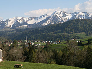
The Bregenz Forest is one of the main regions in the state of Vorarlberg (Austria). It overlaps, but is not coterminous with, the Bregenz Forest Mountains, which belong to a range of the Northern Limestone Alps, specifically the northern flysch zone. It is the drainage basin of the Bregenzer Ach river.
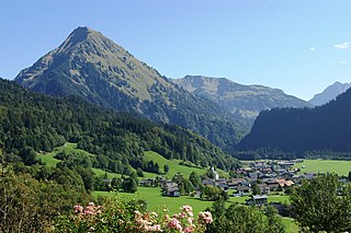
Mellau is a town in the Bregenz Forest in the westernmost Austrian state of Vorarlberg, part of the district of Bregenz.
Bezau is a town in the Bregenz Forest region, in the western Austrian state of Vorarlberg. It is part of the district of Bregenz. Bezau is a popular tourist destination around the year, due to its vicinity to ski resorts and hiking trails. Its picturesque church was built in 1906 and has as its patron saint St. Jodok. Another attraction is the museum of local history (Heimatmuseum), which is housed in a traditional Bregenz Forest wooden home.
Egg is a market town in the Bregenz Forest, in the western Austrian state of Vorarlberg, part of the district of Bregenz. It is the has the highest population of any community in the Bregenzerwald.
Schwarzenberg is a municipality in the Bregenz Forest in the western Austrian state of Vorarlberg, part of the district of Bregenz. Schwarzenberg has an area of 25.76 km². It lies south of Lake Constance. The village center is heritage-protected for its traditional rustic wooden houses.
The Vorarlberg School of Architecture or Guild of Au refers to a group of architects and builders founded in 1657 by Johann Michael Beer in the town of Au im Bregenzerwald in Vorarlberg (Austria).
The Bezirk Bregenz is an administrative district (Bezirk) in Vorarlberg, Austria. It comprises the Bregenz Forest region, the Leiblach valley, and the Austrian part of Lake Constance.
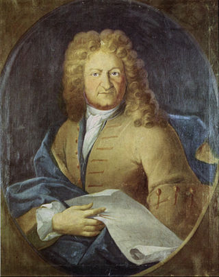
Franz Beer, also known as Franz Beer von Blaichten, was an Austrian architect during the Baroque period, mainly working on church buildings at monasteries in southern Germany, chiefly in Upper Swabia, and Switzerland. His son Johann Michael Beer also was an architect.
Krumbach is a village in the westernmost Austrian state of Vorarlberg, in the Bregenz district. The municipality has about 1,000 inhabitants.
Schoppernau is a town in the Bregenzerwald Region of the Austrian state of Vorarlberg. Schoppernau has an area of 47.64 km2.
Andelsbuch is a municipality in the district of Bregenz in the Austrian state of Vorarlberg.
Hittisau is a municipality in the district of Bregenz in the Austrian state of Vorarlberg. Hittisau has a surface area of 46.65 km². It lies in the Bregenzerwald in the west of the country.
Lingenau is a municipality in the district of Bregenz, in the westernmost Austrian state of Vorarlberg.
Schröcken is a municipality in the district of Bregenz, in the westernmost Austrian state of Vorarlberg.
The Bregenz Forest Mountains, also the Bregenzerwald Mountains, are a range of the Northern Limestone Alps and Eastern Alps, named after the town of Bregenz. The Bregenz Forest Mountains are located entirely in the Austrian state of Vorarlberg.
Kaspar Albrecht was an Austrian architect and sculptor.
The Großes Walsertal is a valley located in the Austrian state of Vorarlberg. It is a side valley of the Walgau and stretches from there north to the mountainous center of the country. The end of the valley borders on the Bregenz Forest.
Franz Michael Felder was a social reformer, author and farmer from Vorarlberg (Austria).