
Dornbirn[ˈdɔʁnbɪʁn] is a city in the Austrian state of Vorarlberg. It is the administrative centre for the district of Dornbirn, which also includes the town of Hohenems, and the market town Lustenau.

Bludenz is a town in the westernmost Austrian state of Vorarlberg. It is the administrative seat of the Bludenz District, which encompasses about half of the Vorarlberg's territory.

Reuthe is a municipality of the Bregenzerwald,in the westernmost Austrian state of Vorarlberg. It is located in the district of Bregenz. Its main industry is tourism.

Lochau is a municipality in the westernmost Austrian state of Vorarlberg. It is located on Lake Constance, in the Bregenz district, near the border to Germany.

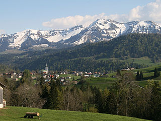
Au is a town in the Bregenz Forest in the westernmost Austrian state of Vorarlberg.

Mellau is a town in the Bregenz Forest in the westernmost Austrian state of Vorarlberg, part of the district of Bregenz.

Bezau is a town in the Bregenz Forest region, in the western Austrian state of Vorarlberg. It is part of the district of Bregenz. Bezau is a popular tourist destination around the year, due to its vicinity to ski resorts and hiking trails. Its picturesque church was built in 1906 and has as its patron saint St. Jodok. Another attraction is the museum of local history (Heimatmuseum), which is housed in a traditional Bregenz Forest wooden home.

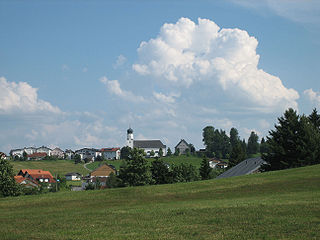
Bizau is a town in the Bregenz Forest in the Austrian state of Vorarlberg, part of the district Bregenz. The municipality has around 1080 inhabitants.

Egg is a market town in the Bregenz Forest, in the western Austrian state of Vorarlberg, part of the district of Bregenz. It is the has the highest population of any community in the Bregenzerwald.

Schwarzenberg is a municipality in the Bregenz Forest in the western Austrian state of Vorarlberg, part of the district of Bregenz. Schwarzenberg has an area of 25.76 km². It lies south of Lake Constance. The village center is heritage-protected for its traditional rustic wooden houses.

Krumbach is a village in the westernmost Austrian state of Vorarlberg, in the Bregenz district. The municipality has about 1,000 inhabitants.

Damüls is a village community and popular tourist resort in the district of Bregenz in the westernmost Austrian state of Vorarlberg. Damüls also holds the European record as the village with the highest annual snowfall – the average is 9.30 meters per year. In 2006, Damüls was awarded the honorary title "the snowiest village in the world".
Hittisau is a municipality in the district of Bregenz in the Austrian state of Vorarlberg. Hittisau has a surface area of 46.65 km². It lies in the Bregenzerwald in the west of the country.

Kennelbach is a community in the district of Bregenz in the westernmost Austrian state of Vorarlberg.

Langen bei Bregenz is a municipality in the district of Bregenz in the Austrian state of Vorarlberg.

Langenegg is a municipality with approx. 1,200 inhabitants in the westernmost Austrian state, Vorarlberg.

Lingenau is a municipality in the district of Bregenz, in the westernmost Austrian state of Vorarlberg.

Riefensberg is a municipality in the district of Bregenz in the westernmost Austrian state of Vorarlberg. The community of Riefensberg covers an area of 14.85 square kilometers. Riefensberg is located within the Nagelfluhkette Nature Park.

Sibratsgfäll is a municipality in the district of Bregenz in the Austrian state of Vorarlberg.
Sulzberg is a municipality in the district of Bregenz, in the westernmost Austrian state of Vorarlberg.


