Krumbach, Vorarlberg

Last updated
Krumbach
HlMartinKrumbachB1.jpg
Wappen at krumbach.png
Coat of arms
Krumbach im Bezirk B.png
Location in the district
Austria adm location map.svg
Red pog.svg
Krumbach
Location within Austria
Coordinates: 47°28′59″N09°56′09″E / 47.48306°N 9.93583°E / 47.48306; 9.93583 Coordinates: 47°28′59″N09°56′09″E / 47.48306°N 9.93583°E / 47.48306; 9.93583
Country Austria
State Vorarlberg
District Bregenz
Government
   Mayor Arnold Hirschbühl
Area
[1]
  Total8.71 km2 (3.36 sq mi)
Elevation
732 m (2,402 ft)
Population
 (2018-01-01) [2]
  Total1,042
  Density120/km2 (310/sq mi)
Time zone UTC+1 (CET)
  Summer (DST) UTC+2 (CEST)
Postal code
6942
Area code 05513
Vehicle registration B
Website www.krumbach.at

Krumbach is a village in the westernmost Austrian state of Vorarlberg, in the Bregenz district. The municipality has about 1,000 inhabitants.

Contents

Geography

Krumbach stretches over an area of 8.71 km². It lies in the "Vorderwald", which is part of the Bregenzerwald. Two rivers, the Weißach and the Bolgenach, flow through Krumbach. Numerous peat bogs are a special landscape feature.

Krumbach is a member of the German-Austrian community project Naturpark Nagelfluhkette.

Culture

The parish church St. Martin was built by local builders and consecrated in 1806. The church interior has primarily Baroque features, with later additions from the 18th and 19th centuries.

The wooden Giessen Bridge, built in 1792, crosses over the river Bolgenach. Nowadays, the bridge is mainly used by hikers from Krumbach to Riefensberg.

In the course of the waterworks renewal in Krumbach in 1999, a "Dorfbrunnen" (village well) was commissioned. Designed by the Bregenzerwälder artist Herbert Meusburger, it represents a portal between the citizens and the church.

Krumbach is part of the Bregenzerwald Umgang (literally "Bregenzerwald Walking Tour"). This walking tour offers insights into the architecture and community planning of 12 traditional villages in the Bregenzerwald. While walking over various landscapes, visiting public buildings, homes and everyday objects, walkers gain a comprehensive overview of typical Bregenzerwald architectural styles as they developed throughout the ages. The focus of the Bregenz Forest Walk in Krumbach is on the extensive peat bogs.

Bus Stop Krumbach

Krumbach is known for its extraordinary bus stops, which were designed by seven international artists. [3] In 2014, the project received special recognition as part of the Austrian National Architecture Awards, and won the National Award for PR. [4]

The city's central bus stop, meant to reflect the particular character of the village center, was redesigned and renovated by the Bregenz Forest architects Bernardo Bader, René Bechter, and Hermann Kaufmann. New bus stops were also commissioned for the surrounding region. [5] The Association Kultur Krumbach asked international designers to create seven small bus shelters for the community; emphasis was placed on the powerful local and regional craftsmanship traditions and indigenous materials, and local craftspeople were to carry out the constructions. The shelters were to synthesize traditional and modern cultural trends. In the end over 300 people were involved in the project.

The international architects chosen were:

Population

Historical population
YearPop.±%
18691,009    
1880944−6.4%
1890888−5.9%
1900792−10.8%
1910755−4.7%
1923708−6.2%
1934737+4.1%
1939651−11.7%
1951771+18.4%
1961759−1.6%
1971778+2.5%
1981836+7.5%
1991913+9.2%
2001933+2.2%
2011990+6.1%

Related Research Articles

Vorarlberg State of Austria

Vorarlberg is the westernmost federal state (Bundesland) of Austria. It has the second-smallest geographical area after Vienna and, although it has the second-smallest population, it also has the second-highest population density. It borders on three countries: Germany, Switzerland, and Liechtenstein. The only Austrian state that shares a border with Vorarlberg is Tyrol, to the east.

Bregenz Forest

The Bregenz Forest is one of the main regions in the state of Vorarlberg (Austria). It overlaps, but is not coterminous with, the Bregenz Forest Mountains, which belong to a range of the Northern Limestone Alps, specifically the northern flysch zone. It is the drainage basin of the Bregenzer Ach river.

Reuthe Place in Vorarlberg, Austria

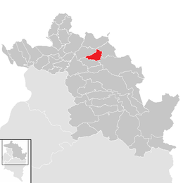
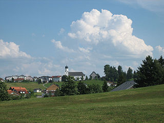
Reuthe is a municipality of the Bregenzerwald,in the westernmost Austrian state of Vorarlberg. It is located in the district of Bregenz. Its main industry is tourism.

Au, Vorarlberg Place in Vorarlberg, Austria

Au is a town in the Bregenz Forest in the westernmost Austrian state of Vorarlberg.

Mellau Place in Vorarlberg, Austria

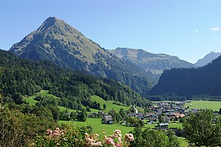
Mellau is a town in the Bregenz Forest in the westernmost Austrian state of Vorarlberg, part of the district of Bregenz.

Bezau Place in Vorarlberg, Austria

Bezau is a town in the Bregenz Forest region, in the western Austrian state of Vorarlberg. It is part of the district of Bregenz. Bezau is a popular tourist destination around the year, due to its vicinity to ski resorts and hiking trails. Its picturesque church was built in 1906 and has as its patron saint St. Jodok. Another attraction is the museum of local history (Heimatmuseum), which is housed in a traditional Bregenz Forest wooden home.

Bizau Place in Vorarlberg, Austria

Bizau is a town in the Bregenz Forest in the Austrian state of Vorarlberg, part of the district Bregenz. The municipality has around 1080 inhabitants.

Egg, Austria Place in Vorarlberg, Austria

Egg is a market town in the Bregenz Forest, in the western Austrian state of Vorarlberg, part of the district of Bregenz. It is the has the highest population of any community in the Bregenzerwald.

Schwarzenberg, Austria Place in Vorarlberg, Austria

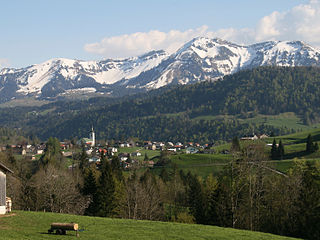
Schwarzenberg is a municipality in the Bregenz Forest in the western Austrian state of Vorarlberg, part of the district of Bregenz. Schwarzenberg has an area of 25.76 km². It lies south of Lake Constance. The village center is heritage-protected for its traditional rustic wooden houses.

Krumbach, Lower Austria Place in Lower Austria, Austria

Krumbach is a market town in southern Lower Austria, Austria. It is part of the landscape Bucklige Welt.

Schoppernau Place in Vorarlberg, Austria

Schoppernau is a town in the Bregenzerwald Region of the Austrian state of Vorarlberg. Schoppernau has an area of 47.64 km2.

Damüls Place in Vorarlberg, Austria

Damüls is a village community and popular tourist resort in the district of Bregenz in the westernmost Austrian state of Vorarlberg. Damüls also holds the European record as the village with the highest annual snowfall – the average is 9.30 meters per year. In 2006, Damüls was awarded the honorary title "the snowiest village in the world".

Doren Place in Vorarlberg, Austria

Doren is a municipality in the district of Bregenz in the western Austrian state of Vorarlberg.

Hittisau Place in Vorarlberg, Austria

Hittisau is a municipality in the district of Bregenz in the Austrian state of Vorarlberg. Hittisau has a surface area of 46.65 km². It lies in the Bregenzerwald in the west of the country.

Langenegg Place in Vorarlberg, Austria

Langenegg is a municipality with approx. 1,200 inhabitants in the westernmost Austrian state, Vorarlberg.

Lingenau Place in Vorarlberg, Austria

Lingenau is a municipality in the district of Bregenz, in the westernmost Austrian state of Vorarlberg.

Riefensberg Place in Vorarlberg, Austria

Riefensberg is a municipality in the district of Bregenz in the westernmost Austrian state of Vorarlberg. The community of Riefensberg covers an area of 14.85 square kilometers. Riefensberg is located within the Nagelfluhkette Nature Park.

Sibratsgfäll Place in Vorarlberg, Austria

Sibratsgfäll is a municipality in the district of Bregenz in the Austrian state of Vorarlberg.

Sulzberg, Austria Place in Vorarlberg, Austria

Sulzberg is a municipality in the district of Bregenz, in the westernmost Austrian state of Vorarlberg.

BUS:STOP Krumbach

The BUS:STOP Krumbach is a construction project of seven bus stops in Krumbach in the Bregenz Forest in Vorarlberg (Austria).

References

  1. "Dauersiedlungsraum der Gemeinden Politischen Bezirke und Bundesländer - Gebietsstand 1.1.2018". Statistics Austria. Retrieved 10 March 2019.
  2. "Einwohnerzahl 1.1.2018 nach Gemeinden mit Status, Gebietsstand 1.1.2018". Statistics Austria. Retrieved 9 March 2019.
  3. "New Images Released of Krumbach, Austria's Famous Bus Stops". ArchDaily. 2014-08-05. Retrieved 2018-06-26.
  4. "Der Staatspreis PR 2014 geht an BUS:STOP Krumbach - PRVA Public Relations Verband Austria". prva.at (in German). Retrieved 2018-06-26.
  5. 1 2 "Bus Stop Krumbach project description". Gemeinde Krumbach (in German). Retrieved 2018-06-26.