Silbertal

Last updated

Silbertal
Silbertal (Osterreich).jpg
Wappen at silbertal.png
Coat of arms
Silbertal im Bezirk BZ.png
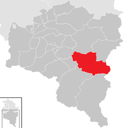
Location in the district
Austria adm location map.svg
Red pog.svg
Silbertal
Location within Austria
Coordinates: 47°04′00″N09°58′00″E / 47.06667°N 9.96667°E / 47.06667; 9.96667 Coordinates: 47°04′00″N09°58′00″E / 47.06667°N 9.96667°E / 47.06667; 9.96667
Country Austria
State Vorarlberg
District Bludenz
Government
   Mayor Thomas Zudrell
Area
[1]
  Total88.6 km2 (34.2 sq mi)
Elevation
889 m (2,917 ft)
Population
 (2018-01-01) [2]
  Total834
  Density9.4/km2 (24/sq mi)
Time zone UTC+1 (CET)
  Summer (DST) UTC+2 (CEST)
Postal code
6780
Area code 05556
Vehicle registration BZ
Website www.silbertal.at

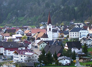
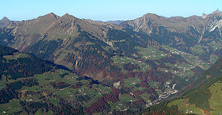
Silbertal is a municipality in the district of Bludenz in the Austrian state of Vorarlberg.

Austria Federal republic in Central Europe

Austria, officially the Republic of Austria, is a country in Central Europe comprising nine federated states. Its capital, largest city and one of nine states is Vienna. Austria has an area of 83,879 km2 (32,386 sq mi), a population of nearly nine million people and a nominal GDP of $477 billion. It is bordered by the Czech Republic and Germany to the north, Hungary and Slovakia to the east, Slovenia and Italy to the south, and Switzerland and Liechtenstein to the west. The terrain is landlocked and highly mountainous, lying within the Alps; only 32% of the country is below 500 m (1,640 ft), and its highest point is 3,798 m (12,461 ft). The majority of the population speaks local Bavarian dialects as their native language, and German in its standard form is the country's official language. Other regional languages are Hungarian, Burgenland Croatian, and Slovene.

Vorarlberg State in Austria

Vorarlberg is the westernmost federal state (Bundesland) of Austria. It has the second-smallest area after Vienna, and although it has the second-smallest population, it also has the second-highest population density. It borders three countries: Germany, Switzerland, and Liechtenstein. The only Austrian state that shares a border with Vorarlberg is Tyrol to the east.

Population

Historical population
YearPop.±%
1869646    
1880645−0.2%
1890637−1.2%
1900593−6.9%
1910541−8.8%
1923467−13.7%
1934540+15.6%
1939523−3.1%
1951582+11.3%
1961629+8.1%
1971774+23.1%
1981834+7.8%
1991347−58.4%
2001873+151.6%
2011869−0.5%

Related Research Articles

Horn, Austria Place in Lower Austria, Austria

Horn is a small town in the Waldviertel in Lower Austria, Austria and the capital of the district of the same name.

Schwarzach, Vorarlberg Place in Vorarlberg, Austria

Schwarzach is a municipality in the Austrian state of Vorarlberg.

Satteins Place in Vorarlberg, Austria

Satteins is a town in the Austrian state of Vorarlberg.

Bildstein Place in Vorarlberg, Austria

Bildstein is a municipality in the district of Bregenz in the Austrian state of Vorarlberg.

Pöchlarn Place in Lower Austria, Austria

Pöchlarn is a town in the district of Melk in the Austrian state of Lower Austria. The painter and writer Oskar Kokoschka was born here in 1886.

Oberperfuss Place in Tyrol, Austria

Oberperfuss is a municipality in the district of Innsbruck-Land in the Austrian state of Tyrol located about 15 km (9.3 mi) west of Innsbruck at the entrance of the Sellrain Valley. It was mentioned in documents around 1083 for the first time.

Herzogenburg Place in Lower Austria, Austria

Herzogenburg is a town in the district of Sankt Pölten-Land in the Austrian state of Lower Austria.

Bludesch Place in Vorarlberg, Austria

Bludesch is a municipality in the district of Bludenz in the Austrian state of Vorarlberg.

Klösterle, Austria Place in Vorarlberg, Austria

Klösterle is a municipality in the district of Bludenz in the Austrian state of Vorarlberg.

Ludesch Place in Vorarlberg, Austria

Ludesch is a municipality in the district of Bludenz in the Austrian state of Vorarlberg.

Nüziders Place in Vorarlberg, Austria

Nüziders is a municipality in the district of Bludenz in the Austrian state of Vorarlberg. It was capital of the historical County of Sonnenberg which is referred to in the formal style of the Emperor of Austria.

Sankt Gallenkirch Place in Vorarlberg, Austria

Sankt Gallenkirch is a municipality in the district of Bludenz in the Austrian state of Vorarlberg.

Sonntag, Austria Place in Vorarlberg, Austria

Sonntag is a municipality in the district of Bludenz in the Austrian state of Vorarlberg.

Höchst, Austria Place in Vorarlberg, Austria

Höchst is a municipality in the district of Bregenz in the Austrian state of Vorarlberg.

Schnepfau Place in Vorarlberg, Austria

Schnepfau is a municipality in the district of Bregenz in the Austrian state of Vorarlberg.

Schlins Place in Vorarlberg, Austria

Schlins is a municipality in the district of Feldkirch in the Austrian state of Vorarlberg.

Haslach an der Mühl Place in Upper Austria, Austria

Haslach an der Mühl is a municipality in the district of Rohrbach in the Austrian state of Upper Austria.

Altschwendt Place in Upper Austria, Austria

Altschwendt is a municipality in the district of Schärding in the Austrian state of Upper Austria.

Frankenmarkt Place in Upper Austria, Austria

Frankenmarkt is a municipality in the district of Vöcklabruck in the Austrian state of Upper Austria.

Schörfling am Attersee Place in Upper Austria, Austria

Schörfling am Attersee is a municipality in the district of Vöcklabruck in the Austrian state of Upper Austria.

References

  1. "Dauersiedlungsraum der Gemeinden Politischen Bezirke und Bundesländer - Gebietsstand 1.1.2018". Statistics Austria. Retrieved 10 March 2019.
  2. "Einwohnerzahl 1.1.2018 nach Gemeinden mit Status, Gebietsstand 1.1.2018". Statistics Austria. Retrieved 9 March 2019.