Gaschurn

Last updated
Gemeinde Gaschurn-Partenen
Gaschurn Gundalatschaberg 1.JPG
Wappen at gaschurn.png
Coat of arms
Gaschurn im Bezirk BZ.png
Location in the district
Austria adm location map.svg
Red pog.svg
Gemeinde Gaschurn-Partenen
Location within Austria
Coordinates: 46°58′00″N10°01′00″E / 46.96667°N 10.01667°E / 46.96667; 10.01667 Coordinates: 46°58′00″N10°01′00″E / 46.96667°N 10.01667°E / 46.96667; 10.01667
Country Austria
State Vorarlberg
District Bludenz
Government
   Mayor Martin Netzer
Area
[1]
  Total176.78 km2 (68.26 sq mi)
Elevation
979 m (3,212 ft)
Population
 (2018-01-01) [2]
  Total1,464
  Density8.3/km2 (21/sq mi)
Time zone UTC+1 (CET)
  Summer (DST) UTC+2 (CEST)
Postal code
6793
Area code 05558
Vehicle registration BZ
Website www.riskommunal.net/
gaschurn

Gemeinde Gaschurn-Partenen is a municipality in the district of Bludenz in the Austrian state of Vorarlberg. Two largest villages are Gaschurn Dorf (population 1083 as of 2019-01-01) and Partenen (population 376 as of 2019-01-01).

Contents

Geography

The center of Gaschurn lies 979 m above sea level. It is located in the Montafon valley between Gortipohl and Partenen (the latter belongs to the municipality of Gaschurn). 12.7 percent of the municipal area is forested, and 51.7 percent are Alpine land.

The municipality is crossed by the river Ill, on the right of which is the Verwall mountains and on the left the Silvretta mountain range.

Population

Historical population
YearPop.±%
18691,101    
1880954−13.4%
1890934−2.1%
1900866−7.3%
1910828−4.4%
1923807−2.5%
19341,229+52.3%
19391,501+22.1%
19511,660+10.6%
19611,750+5.4%
19711,710−2.3%
19811,691−1.1%
19911,714+1.4%
20011,651−3.7%
20111,529−7.4%

History

The Romansh place names are already mentioned in documents of the 15th century (1423 "Gaschurra", 1499 "Parthenna"), some alps even earlier (for example, 1089 "alpem in Signes" = Zeinisalpe). Benefiting from the warmer climate in the Middle Ages, but also until the 18th century, the high alp Vermunt was used by farmers from Ardez and Guarda in the Lower Engadine (cattle drive over the Vermuntpass).

The Habsburgs ruled the places in Vorarlberg alternately from Tyrol and Vorderösterreich (Freiburg im Breisgau). From 1805 to 1814, the place belonged to Bavaria, then again to Austria. Gaschurn belongs to the Austrian state of Vorarlberg since the foundation of the state in 1861.

In the middle of the 19th century, summer tourism is becoming popular. In 1885, a society for the city embellishing was founded. Several Alpine Club huts were opened: 1885 Madlenerhaus, 1896 Wiesbadener Hütte, 1908 Tübinger Hütte, 1910 Saarbrücker Hütte, 1927 Heilbronner Hütte. Around 1910, the road construction started from Schruns to Partenen.

Coat of arms

The coat of arms was created in 1966 to a design by the Schruns artist and heraldist Konrad Honold. It shows next to the crossed papal keys a water wheel and a halberd. This refers to the local hero Lukas Tschofen, who was associated with all sorts of benefits.

Culture

The Tourism Museum Gaschurn was opened in 1992 in Gaschurn as the first tourism museum in Austria.

Parish Church Hl. Michael Gaschurn, katholische Pfarrkirche heilige Michael in straatzicht Dm65344 positie2 foto5 2014-07-23 09.47.jpg
Parish Church Hl. Michael

Completed in 1986, the new community center of the village exhibits a 300-year-old traditional "Montafoner Stube" – the so-called Lukas Tschofen-Stube.

The parish church Gaschurn, a neo-Romanesque church, was inaugurated in 1869 by Bishop Franz Josef Rudigier, who was born in Partenen. The altar and ceiling paintings were created by the Schrunser brothers Franz and Jakob Bertle in the late Nazarene style.

Chapel Maria Schnee Kapelle Maria Schnee in Gaschurn und Michaelskirche.JPG
Chapel Maria Schnee

Chapel Maria Schnee. According to the inscription, the construction of the chapel dates back to 1637. The founder and builder is Lukas Tschofen, a legendary and legendary figure of the Montafon valley. The chapel houses a picture of Maria Hilf (copy of a picture of grace by Lucas Cranach the Elder) and has become a popular Marian pilgrimage site. The chapel is located on a small hill in the center of the village.

Sports

As the largest municipality in Vorarlberg, a large network of hiking trails (altogether 266.8 km) and numerous mountain bike trails (altogether 71.9 km) are provided. From Partenen via Gaschurn to St. Gallenkirch there is a 12 km long cycling, walking and winter hiking trail.

Panoramic view of Gaschurn Gaschurn Panorama.jpg
Panoramic view of Gaschurn

Related Research Articles

Vorarlberg State in Austria

Vorarlberg is the westernmost federal state (Bundesland) of Austria. It has the second-smallest area after Vienna, and although it has the second-smallest population, it also has the second-highest population density. It borders three countries: Germany, Switzerland, and Liechtenstein. The only Austrian state that shares a border with Vorarlberg is Tyrol to the east.

Bludenz Place in Vorarlberg, Austria

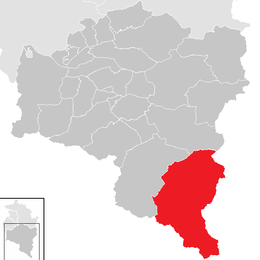
Bludenz is a town in the Austrian state of Vorarlberg. It is the administrative seat of Bludenz District, which encompasses about half of the state's territory.

Silvretta Alps mountain range in the Alps

The Silvretta Alps are a mountain range of the Central Eastern Alps shared by Tirol, Vorarlberg and Graubünden (Switzerland). The Austrian states of Tirol and Vorarlberg are connected by a pass road. The majority of the peaks are elevated above three thousand metres and are surrounded by glaciers. Thus, the area is also known as the "Blue Silvretta".

Rätikon mountain range of the Alps

The Rätikon is a mountain range of the Central Eastern Alps, located at the border between Vorarlberg, Liechtenstein and Graubünden. It is the geological border between the Eastern and Western Alps and stretches from the Montafon as far as the Rhine. In the south, the Prättigau is its limit, and in the north, it is the Walgau. In the east, it borders the Silvretta groups. The Rätikon mountain range derives its name from Raetia, a province of the Roman Empire, named after the Rhaetian people.

Montafon is a 39 km long valley in the federal state of Vorarlberg (Austria) that is crossed by the river Ill (Vorarlberg). It extends from the city of Bludenz and the Verwall Alps in the north, to the Silvretta and Rätikon mountain range in the south. Piz Buin is with 3312m the highest peak within the Silvretta mountain range. The area has a population of 16.642 people.

Schruns Place in Vorarlberg, Austria

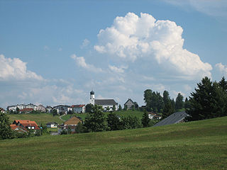
Schruns is a municipality in the Montafon valley in the Austrian state of Vorarlberg in the Bludenz district.

Tschagguns Place in Vorarlberg, Austria

Tschagguns is a village in the Montafon valley, Bludenz district in the Austrian state of Vorarlberg. Tschagguns offers skiing with its own ski resort called Golm. Tschagguns offers hiking, mountain biking, winter sports and much more. Gauertal is a valley found in Tschagguns between Mittagspitze and Golm. It is famous for the "3 Türme" which means 3 Towers.

Lochau Place in Vorarlberg, Austria

Lochau is a municipality in the Austrian state of Vorarlberg. It is located on Lake Constance, in the Bregenz district near the border to Germany.

Au, Vorarlberg Place in Vorarlberg, Austria

Au is a town in the Bregenz Forest in the Austrian state of Vorarlberg, part of the district of Bregenz.

Schwarzenberg, Austria Place in Vorarlberg, Austria

Schwarzenberg is a municipality in the Bregenz Forest in the Austrian state of Vorarlberg, part of the district of Bregenz. Schwarzenberg has an area of 25.76 km². It lies south of Lake Constance. The village center is heritage-protected for its clapboard houses.

Fontanella, Austria Place in Vorarlberg, Austria

Fontanella is a municipality in the Austrian state of Vorarlberg.

Sankt Anton im Montafon Place in Vorarlberg, Austria

Sankt Anton im Montafon is a town in the Montafon valley in the district of Bludenz in the Austrian state of Vorarlberg.

Damüls Place in Vorarlberg, Austria

Damüls is a municipality and popular tourism resort in the district of Bregenz in the Austrian state of Vorarlberg. Damüls also holds the world record of the municipality with the most annual snowfall in Europe – the average is 9.30 meters per year. In 2006, Damüls was awarded the honorary title "the snowiest village in the world".

Brand, Vorarlberg Place in Vorarlberg, Austria

Brand is a municipality in the district of Bludenz in the Austrian state of Vorarlberg.

Doren Place in Vorarlberg, Austria

Doren is a municipality in the district of Bregenz in the Austrian state of Vorarlberg.

Schröcken Place in Vorarlberg, Austria

Schröcken is a municipality in the district of Bregenz in the Austrian state of Vorarlberg.

Sibratsgfäll Place in Vorarlberg, Austria

Sibratsgfäll is a municipality in the district of Bregenz in the Austrian state of Vorarlberg.

Sulzberg, Austria Place in Vorarlberg, Austria

Sulzberg is a municipality in the district of Bregenz in the Austrian state of Vorarlberg.

Silvretta Montafon (Ski area)

The Silvretta Montafon ski area is located in the Montafon valley in Vorarlberg (Austria). It is one of Austria's ten largest ski areas. The Silvretta Montafon ski area originally existed of the two ski areas Silvretta Nova and Hochjoch that have been merged in 2008.

Stuben am Arlberg Place in Vorarlberg, Austria

Stuben am Arlberg is a winter sports resort in the municipality Klösterle in the Austrian province of Vorarlberg. It is located at 1410 m AA and counts 90 inhabitants.

References

  1. "Dauersiedlungsraum der Gemeinden Politischen Bezirke und Bundesländer - Gebietsstand 1.1.2018". Statistics Austria. Retrieved 10 March 2019.
  2. "Einwohnerzahl 1.1.2018 nach Gemeinden mit Status, Gebietsstand 1.1.2018". Statistics Austria. Retrieved 9 March 2019.

Commons-logo.svg Media related to Gaschurn at Wikimedia Commons