
Salzburg is an Austrian federal state. In German it is called a Bundesland, a German-to-English dictionary translates that to federal state and the European Commission calls it a province. In German, its official name is Land Salzburg, to distinguish it from its eponymous capital Salzburg. For centuries, it was an independent Prince-Bishopric of the Holy Roman Empire. It borders Germany & Italy.

The Grossglockner, or just Glockner, is, at 3,798 metres above the Adriatic (12,461 ft), the highest mountain in Austria and the highest mountain in the Alps east of the Brenner Pass. It is part of the larger Glockner Group of the Hohe Tauern range, situated along the main ridge of the Central Eastern Alps and the Alpine divide. The Pasterze, Austria's most extended glacier, lies on the Grossglockner's eastern slope.

The Kitzbühel Alps are a mountain range of the Central Eastern Alps surrounding the town of Kitzbühel in Tyrol, Austria. Geologically they are part of the western slate zone.

The Central Eastern Alps, also referred to as Austrian Central Alps or just Central Alps, comprise the main chain of the Eastern Alps in Austria and the adjacent regions of Switzerland, Liechtenstein, Italy and Slovenia. South them is the Southern Limestone Alps.
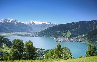
Zell am See is the administrative capital of the Zell am See District in the Austrian state of Salzburg. Located in the Kitzbühel Alps, the town is an important tourist destination due to its ski resorts and shoreline on Lake Zell. While Zell am See has been a favored winter and summer resort for the European aristocracy since the 19th century, it is known as a hub of the international jet set today.

The Bezirk Zell am See is an administrative district (Bezirk) in the federal state of Salzburg, Austria, and congruent with the Pinzgau region.

Krimml is a municipality in Zell am See District, in the federal state of Salzburg, Austria, in the Pinzgau region.

The Pfänder is a mountain in western Austria close to Lake Constance. The city of Bregenz lies at the foot of the mountain on the shores of the lake. With its views over the lake and the surrounding mountain peaks, the Pfänder is one of the most famous lookout points of the region.
Zeller, meaning both prisoner and monk in German, may refer to:

Saalfelden am Steinernen Meer is a town in the district of Zell am See in the Austrian state of Salzburg. With approximately 16,000 inhabitants, Saalfelden is the district's largest town and the third of the federal state after Salzburg and Hallein.

Piesendorf is a municipality in the district of Zell am See, in the state of Salzburg in Austria. It lies in the Kitzbühel Alps between Kitzbühel and Zell am See. Due to its location between the ski resorts of Zell am See, Kitzbühel and the Hohe Tauern National Park with Austria's highest mountains, it has become centered on tourism. Piesendorf lies directly across from the Kitzsteinhorn and the Großglockner, the latter being Austria's tallest peak.
Dienten am Hochkönig is a municipality in the district of Zell am See, in the state of Salzburg in Austria. The population is 800.
The Berchtesgaden Alps are a mountain range of the Northern Limestone Alps, named after the market town of Berchtesgaden located in the centre. It is crossed by the Austria–Germany border: the central part belongs to the Berchtesgadener Land district of southeastern Bavaria, Germany, while the adjacent area in the north, east and south is part of the Austrian state of Salzburg.
The Salzburg Slate Alps are a mountain range of the Eastern Alps, in the Austrian state of Salzburg. Situated within the greywacke zone, they could be regarded either as part of the Northern Limestone Alps or of the Central Eastern Alps.

The Großer Hundstod is, at 2,593 metres, one of the main peaks in the Steinernes Meer in the Berchtesgaden Alps, and lies on the border between Bavaria and the Austrian state of Salzburg.

The Schmittenhöhe is a mountain, 1,965 m (AA) high, on the eastern edge of the Kitzbühel Alps. It is the local mountain of the district capital of Zell am See, from where a cable car was built in 1927 by Adolf Bleichert & Co. that runs to the summit. The cable car system has been renovated several times since. From the summit of the Schmittenhöhe there is a good view of over 30 three-thousanders as well as the lake of Zeller See, the river basin and the whole Saalach valley.
The Pinzgau Hut or Pinzgauer Hut is a mountain hut at 1,700 m (5,577 ft) above sea level in the Kitzbühel Alps in Salzburg, Austria.
The Pinzgau Ridgeway is a roughly 25 kilometre long ridgeway in the Kitzbühel Alps in the Austrian federal state of Salzburg.
The Hoher Tenn, formerly also called the Hochtenn, is a double-peaked mountain in the Austrian federal state of Salzburg. It has a southwest summit, called the Bergspitze with a height of 3,368 metres (11,050 ft), and a northeast summit, the Schneespitze, which is 3,317 metres (10,883 ft) high. The Tenn belongs to the Glockner Group in the central part of the High Tauern in the Austrian Central Alps. Between the two summits at a height of 3,293 metres (10,804 ft) is the Tenn Saddle (Tennsattel). Long knife-edge ridges run away to the northeast and northwest. It has a large topographical prominence, especially to the north, which, together with its easy accessibility, make it a popular climbing mountain. Seen from Zell am See in the Pinzgau it is second only to the Imbachhorn in dominating the Tauern panorama.

