| Wallersee | |
|---|---|
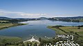
 Aerial view of the Wallersee from the southwest | |
 Wallersee  Wallersee | |
| Location | AT-5 |
| Group | Salzburger Seengebiet |
| Coordinates | 47°54′50″N13°10′30″E / 47.9139°N 13.175°E |
| Type | natural |
| Part of | Salzach |
| Primary inflows | Altbach |
| Primary outflows | Fischach |
| Basin countries | Austria |
| Water volume | 76,300,000 m3 (2.69×10⁹ cu ft) |
| Islands | 0 |
The Wallersee is a lake in the Austrian state of Salzburg northeast of the city of Salzburg in Salzburg-Umgebung District.
Contents
Around the lake there is a hiking path of about 20 km (12 mi) length; at its southern part, it converges with the famous Camino de Santiago (Austrian route). [1] There are two campsite resorts. It is allowed to swim and bath.
The northern shore consists of bogland since 1883 and is called Wenger Moor. [2]